Maps
Maps 1
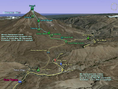
Maps and Signs for Mt Damavand
In this topic you will find helpful and interesting road and route maps. These maps shows you all the ways and footpaths of the mountain, from Tehran to starting points, from camps to the peak, you will learn how to go to the summit of Iran and Middle East by your own. Some original full size image maps are avalable free of cahrge, interested mountaineering groups and individual climbers may send their request with the title Mt Damavand Map in the email subject.

Mt Damavand South Route Map

Road Map from Tehran To the area

Road Map from Tehran international Airports

Road Map Tehran To Caspian Sea, Haraz and Chalus Roads
More in MDG
Iran mountain camps, shelters and huts map, trekking and expedition map, gps landmark waypoint iran mountain, hiking & trekking map iran damavand, ski mountaineering tour iran, route and trail map, google earth satellite image iran, elburz mountains map, iran map, east, west, north, south route, gps iran, trail map, how to go, how to reach, climbing route, trail map iran damavand.
Maps 2 MDG8807029A
Copyright © Mount Damavand Guide . All rights reserved.
Labels: Maps
0 Comments:
Post a Comment
<< Home