Simorgh Shelter
Simorgh Shelter
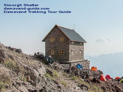
The Simorgh Shelter or Simorgh Refuge is a Damavand Camp which located on the western trekking trail of Iran's Mount Damavand, Iran. Simorgh Camp's two-story building gives room for about 40 climbers. It is possible to pitch up at least 40 to 50 tents at a tenting campsite next to the Simorgh refuge (latitude: 35.9564°, longitude: 52.0825°, elevation: 4,200 m), making it suitable for climbers even on busy days. The Simorq mountain shelter has lighting both inside and outside that is powered by solar energy. There is currently no water in the shelter's outdoor restroom. The snowmelt flowing water, which is 150 meters northeast of Simorgh camp, is the only water source in this mountain camp site.

Mt. Damavand West Trail Climbing Tour Guide
Simorgh Shelter lat: 35.9564° – lon: 52.0825° – alt 4,200 m
You can also Climb Damavand by going west. After the traditional south path, it is the mountainside that sees the second-highest number of climbers. You must first travel to Polour Camp from the Haraz Road if you want to hike Damavand from the western front. Off-road vehicles from Polour can transport you through Lar Road and to the starting point of the Damavand West Trekking Route, also known as the Parking Area or Damavand West Route Basecamp, throughout the summer. The ascent often begins from Vararood's west front base camp to Damavand.

This base camp (Parking Area) is located at an altitude of around 3400 meters above sea level. To get to Simorgh shelter, you must hike from the parking lot. The Simorgh camping area has running water, which is a useful amenity. Spend the night in the tenting area or the Simorgh shelter. The climb from the parking lot to the Simorgh shelter takes about 3–4 hours. Depending on your physical condition, ability to breathe, and level of readiness, it could take you anywhere between 5-7 hours to reach the west summit of the Damavand volcano crater from Simorq shelter.

Simorgh Shelter lat: 35.9564° – lon: 52.0825° – alt 4,200 m
0 Comments:
Post a Comment
<< Home