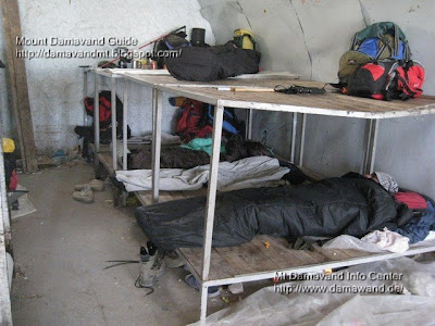
Takht Fereydon Shelter
At 4,380 meters above sea level, Takhte Fereydoun Shelter is situated on the Damavand north-east route. Twenty to twenty-five climbers can stay in this Damavand Camp, and tents can be set up all around it. A small spring (water from the snowmelt) on the shelter's northern side serves as the summertime water source for climbers. There are two floors.

Takhte Fereydoun Shelter
Lat: 35.9665°, Lon: 52.1341°, Alt: 4,380 m
Trekking Damavand from the eastern trail, for the most part, the rocks, snow, and ice cover the summit trail as it ascends. After passing through the Gardaneh-Sar and the beginning of the northeast ridge, there is a clear footprint, and it takes about 6 hours to ascend to Takhte Fereydoon shelter (lat: 35.9665°, lon: 52.1341°). There are two places along the path where you can use the snowmelt water, but if you're not used to drinking water from snow, it's best to avoid doing so.
Takht Fereydon Campsite
The last place where water may be taken from the glaciers is 100 meters away, on the slope leading to Takht-e Fereydun shelter. The shelter is located on the Yakhar glacier's edge. Near the shelter, tents might be erected. Takht Fereydoun shelter is a good place to set up camp and spend the night. The region has both water (snowfall) and wind protection on the refuge's ridge; but, in the morning, one must climb a challenging slope to reach Damavand top.

Takhte Fereydoun Refuge Location
Damavand Mountain North-East Route
Damavand Attraction in the Northeast
The northeast face's innate beauty is well acknowledged. It has plenty of water and plants. In addition to being more difficult to access than other slopes of Damavand, its protection from hunters has made it a haven for endangered species. These elements combined to form a pristine land on the northern face.
Takht Fereydon Shelter 23MDG0227A