09 January 2010

Cave-QuriQaleh


Quri Qaleh Cave
Caves of Iran, QuriQaleh
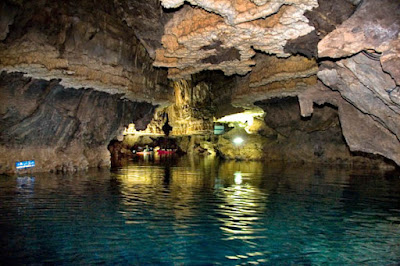
The majestic QuriQaleh Cave is 13 kilometers long and the longest water cave of Iran and the Middle East, it is a two level cave with huge calcite, stalactites, stalagmites and long corridors and passageway. Visitors are amazed by numerous rock formations and extraordinary stalactites, which can resemble any object, such as snakes, elephants, ships, bride, and Mary mother of Jesus.

Cave Quri Qaleh
QuriQaleh Cave, Kermanshah Iran
Photo by Abdolah Moradi

The visiting pathway includes two levels of the cave, the 550m long upper route with two chambers and some interesting parts such as a main hall, Wedding Hall or Bride Hall, in persian Talare Aroos, which is the most impressive part of, the Crystal Hall or Talare Bolour with cave lakes and bright, shining crystals and 4 stone waterfalls shapes each up to 10 to 12m high and stalagmites in the chamber up to 8m high and also, The Mary Hall and the Prayer Hall or Talare Namaz.

Ghar e Ghoori Ghaleh
Ghoory Ghaleh, Kermanshah Iran
Photo by Abdolah Moradi

The origin of the name is not quite clear, some say the original name was Goori Gabr, which means the 'grave of the non Muslims', and the other say it is a Turkish name meaning 'dry castle', but there is a nearby village with the same name called QuriQaleh, a colony of rare mouse ear bats are living inside.

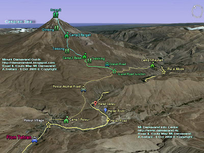
A very cool tourist destination for foreign climbers who intend to climb Mt Damavand, besides climbing Damavnd the highest peak of the Middle East, it is a recommended target to visit the longest water cave of Middle East too.

Although no majore archaeological research have been made, but numerous historical objects have been found near the entrance of mostly by accident. The main objects found in the cave are:
- One human skull 800 years ago.
- Two vases filled with gold coins.
- One vase, a tablet from the Sassanid era (205-651 AD).
- 15 coins, from Yazd Gerd III, the last Sassanid kingdom.
- Remains from the Sassanid Period.
- Various clayworks from Prehistoric times.

Ghar e Quri Qaleh
Quri Qaleh, Kermanshah Iran
Photo by Abdolah Moradi

Quick Facts
13 kilometers long, water cave, Asia's longest cave
Ghoori Ghaleh, millions of years old, but undiscovered until recent decades.
Temp: 7 t0 11 deg C

Longest Caves in Iran
1- QuriQaleh 13 Km, watercave
2- Katalehkhor 12.8 Km
3- Alisadr, 11.5 km, water cave
4- Karafto 750 m,

History
The entrance was known to locals for ages, but they believed it was only a small cave and just a few meters deep, in 1950 a team of investigators explored the cave and discovered the magnificence of Ghoori Ghaleh, first 550m leading to a 55m deep shaft discovered, no other major discovery took place in the cave until 1989 which the main parts of the cave was excavated by an Iranian adventurer youg team,, they opened a path 3,140 m long into the heart of the cave.

- 1957 to 1984 American, British, and French speleologists explore 550m of cave.
- 1989 young Iranian adventurers excavate and explore further 1,340m.

Alternate names and spellings
QuriQaleh, Quri Qaleh, Ghar e Quri Qaleh, ,Ghar e Ghoori Ghaleh
Ghoory Ghaleh,
In Persian: غار قوری قلعه, غار قوریقلعه, غار آبي قوري قلعه

Major Caves in Iran
Alisadr Hamedan Iran, water cave.
Karafto , natural and historical cave.
Moon , Cave civilization.
Quri Qaleh Kermanshah.
Sahoolan Mahabad, pigeon cave, water cave
Shapour Kazeroon, statue king shapour the great.
Vara Jahrom , Temple.

Geographic Location and Coordinate
GPS Landmark for
Altitude:
Latitude:
Longitude:

How to go there
86 km on Kermanshah to Paveh road, Kermanshah Province, western Iran
25 Km to Ravansar City.

Cave of Ghoory Ghaleh
QuriQaleh , Kermanshah Iran
Photo by Abdolah Moradi

More in MDG
Mt Damavand, geology and formation, multi level caves iran, historical kordestan iran, tour iran, tour damavand 2010, caves tour iran, photo iran caves, alborz caves gps, visit ancient caves in iran, persia caves, tour 2010 mt. damavand, iran tourist destination and targe, iran mountain info center, discover asia longest caves, explor nature, discover the wonders hidden inside iran,

Cave QuriQaleh MDG9JAN10A
Copyright © Mount Damavand Guide . All rights reserved.

Labels:

06 January 2010

Cave-Katalehkhor


Katalehkhor
Caves of Iran
The magnificent Katalehkhor Cave is a huge multi level cave with cross-connection, parallel passages and gigantic calcite, it includes a 100m long main hall called Wedding Hall which is completely covered by calcite crystals.

It is made of limestone with several giant stalactites and stalagmites and some long corridors, it is consist of three mainly dry floor and there is a possibilty of a forth floor under the water, so far the dry part is explored.

There are cresset in interesting shapes such as sleeping lion, lion paw, elephant foot, stone waterfall, candle, deer-dog, adust palm tree, the virgin mary, married couple, bride dress in marriage ceremony table.

ghar Katalehkhor
Ghar Katalehkhor, Zanjan Iran, Photo by A.Soltani

At the moment there are two different route for visitors, the first one is 1,250m long straight path for ordinerary people, which at the end this path visitors return back the same way, so the total length is 2.5 km, the second route is a 4 km long route for more experts.

The archeologists say it has been a residential place in the past and there are many bones and fossils of the anciant years. Ghar Katalehkhor is developed in Oligocene/Miocene limestone age.
If you have planed to visit Iran outdoor recreation and Mt Damavand, do not miss this beautiful cave.

Cave Katalehkhor
Katalekhor Cave, Zanjan Iran, Photo by Ardeshir Soltani

Quick Facts
- Light: electric.
- Length: 12,860m
- Guided tours: L=2,500m.
- It is the longest cave of the Iran.
- is formed in Jurassic period (about 120 million years ago).

Geographic Location and Coordinate for Katale Khor Cave
400 km west of capital Tehran, in Zanjan Province, Iran.
165 kilometer South West of Zanjan City
7 km from Garmab City.

ghar Katalehkhor
Katale khor, Zanjan Iran, Photo by A.Soltani

GPS Landmark for Katalehkhoor Cave
Altitude: 1715m
Latitude: 35-50-12 N
Longitude: 48-09-43E

How to go there
There are different ways to reach the area:
Thehran> Karaj> Qazvin> Zanjan Road> before Zanjan City> Soltanieh> Khoda Bandeh> Garmab> Katalehkhor

Or Zanjan City> Bijar> > Garmab> Katalehkhor
Or Hamadon City> Kabod Ahang > Kataleh khor

Alternate names and spellings
Katale khor , Katalekhor, Katalekhoor, Katale khour, Catalekhor, Catale Khor , ghar e Katalekhor, ghar Katalehkhor
In Persian: غار کتله خور

Katalehkhor ghar
Katalekhor Cave, Zanjan Iran, Photo by A.Soltani

Quick History
- 1965 it was discovered by mountaineers from Hamadan.
- 1984 The cave was first studied by geologistis.
- 2003 a speleological team explored and surveyed the Cave, the surveying team consisted of four participants:
Mr. H. Akbarzadeh, Geological Survey of Iran.
Mr. Javad Ashjari, Geological Department of Shiraz University.
Mr. Michael Laumanns, from Germany
Mr. Reinhold Scherrer, from Switzerland.

Other Major Caves in Iran
Alisadr Hamedan Iran, water.
Karafto , natural and historical .
Moon , Cave civilization.
Quri Qaleh Kermanshah.
Sahoolan Mahabad, pigeon , water
Shapour Kazeroon, statue king shapour the great.
Vara Jahrom , Temple.

Cave Katale khour
Katale khor, Zanjan Iran, Photo by A.Soltani


Cave Katalehkhor
Katalehkhor, Zanjan Iran, Photo by A.Soltani


Cave Katale khor
Katalehkhor, Zanjan Iran, Photo by A.Soltani


Cave Katalehkhor
Katalehkhor , Zanjan Iran, Photo by A.Soltani


Cave Katale khor
Katalehkhor, Zanjan Iran, Photo by A.Soltani


Cave Katalehkhor
Katalehkhor, Zanjan Iran, Photo by A.Soltani


Cave Katalehkhor
Ghar Katalehkhor, Zanjan Iran, Photo by A.Soltani


Cave Katale khour
Katalehkhor , Zanjan Iran, Photo by A.Soltani

More in MDG
Mt Damavand info center, formation and geology, multi level caves in iran, historical caves carving, natural, historical caves tour iran, damavand tour, 2010 iran tour, photo and picture iran caves, alborz mount caves, damavand, gps landmark iran, caves carving persia, tour 2010 damavand.

Katalehkhor MDG6JAN10A
Copyright © Mount Damavand Guide . All rights reserved.

Labels:

05 January 2010

Cave-Karafto


Karafto Cave
Caves of Iran
Karafto Cave, Persian Fire Temple,Temple of Heracles
Iran has many beautiful caves for sightseeing, with several visitors each year, Karafto is one of the most visited popular natural attraction in the country. It contains a series of natural and man made caves connected together via various tunnels and corridors through the rocks, difficult narrow rotes for some strategical reasons. It is a unique natural and pre-historical archeological site.

Cave Karafto
Karafto Kurdestan Iran, Photo by A. Soltani

At the front side there are some man made rooms with windows toward the vally to see the beautiful sceneries and in the complicated network of passages and corridors, there are some natural water wells and spring for drinking water. The cave entrance is situated at 25 m high of a steep mountain making entry very difficult, probably its been been used as stronghold against enemy, nowadays entering the cave is made easy by stairs.

Cave Karafto
Karaftou, Kurdestan Iran, Photo by Aredeshir Soltani

After architectural investigations and researches, the archeologists named it as a pre-historical cave and indicate that this site and the natural part of the caves has been a residential area for the last 10,000 years ago and there are evidence back to 7000 years old.
There are retrace of old Persian empire dynasty, Sassanid, Ilkhanid Mongol, Seleucids a dynasty of Macedonian kings, important temples, persian fire temple and a Greek goddess Heracles "Hercules" temple and some relics date back to 300 BC. Later this pre historic cave modified by man for other usage.

Cave Karafto
Caraftoo Cave Kurdestan Iran, Photo by Sherppa

We have no idea of its old ancient names, but its new name is taken from the neighbouring village of Karafto 12 km away. It is located at 72 km east Seqiz City in Kordestan Province Iran.
The main parts of it is natural including a 600 meters long corridor with 1 to 10 m height, and secondary corridor connecting all passages, rooms and halls together.
If you have a plane for visiting Iran natural attraction and Mount Damavand, do not miss this marvelous site.

Cave Karafto
Karaftu Cave Kurdestan Iran, Photo by Ardeshir Soltani

Quick History
There are some illustrations and carvings on the walls of the rooms date back to the ancient historical era, a horse rider hunting a deer which is believed to illustrate king Goudarz from Persian Ashkanid dynasty, the name of a Greek god Heracles " or Herakles" is carved on one of the walls of the third floor room, the Greek inscription reads, “Here is Helcules’ home, everybody who enters (this place) will be safeguarded.”

Also other illustrations showing various war triumph of Goudarz and Mehrdad the Ashkanid kings in persian empire. The area has been an important part of persian Silk Road, which many caravans have passed through this road, indicating the importance of this region.

Karafto
Karafto Kurdestan Iran, Photo by A. Soltani

Quick Facts
- Itslength is about 750 m, the longest corridor is 600 m with a various height from 1 to 10 m .
- It has 4 Floors with some balconies .
- It has two different sections, natural and human-made.
- It is a mixture of rock architecture, history, and nature.
- Artificial man made rooms have windows to use daylight.
- There are some inscription, epigraphs dated back to 2000 years ago.
- One tablets written in Greek on the 3rd floor.
- Many pigeon are living there.

Cave Karafto
Kereftu Kurdestan, Photo by A. Soltani

Location and Coordinate
located 72 km east of Seqiz City, Kordestan, Iran.

GPS Landmark for Karafto Cave
Altitude: 2030 M
Latitude: 35-19-57 N
Longitude:46-52-39 E

How to go there by Road
There are 3 different ways, the main access is from Tehran, highway from Tehran to Zanjan and ordinary roads for the rest.

Thehran> Karaj> Qazvin> Zanjan> Bijar> Divanddareh> Takab junction> Goor Baba Ali> Youzbash Kandy Village> Karafto .

Also you may reach the area through
Saqez City> Saheb Village to Mirsaeid Village road> Karafto.
Or Takab City> Aliabad Village> Karafto.

Cave Karafto
Eşkewti Kereftû Kurdestan Iran, Photo by Soltani

What a Shame!
Although it is registered on the National Cultural Heritage List, but some of the illustrations of animal and floral drawn in ancient times on the walls and some cave carvings have been destroyed by graffiti and thoughtless individuals Iranian visitors!

Alternate names and spellings
Karaftuo, Karaftou, Caraftoo, Karaftu, Kereftu, Carafti
In Kourdish: Eşkewti Kereftû کَرَفتو : ئه‌شکه‌وتی که‌ره‌فتوو
In Persian: غار کرفتو

Cave Karafto
Karafto Cave Kurdestan Iran, Photo by Aredeshir Soltani

Other Major Caves in Iran
Alisadr Hamedan Iran, water cave
Katalekhor Zanjan,
Moon, civilization
Quri Qaleh Kermanshah
Sahoolan Mahabad, pigeon , water
Shapour Kazeroon, statue of king shapour the great
Vara Jahrom , temple

Cave Karafto
Karaftou Kurdestan Iran, Photo by A. Soltani

Natural Attraction of Kurdestan Iran
Kurdistan province is covered a collection of lake, mountains, forests, hills, rivers, lakes and natural caves and attract many tourists for ski, mountaineering sport, and water sports each year.
Kurdistan has vast forests and refuges for wild life, animals like leopard, wild goat, hyena, jackal, wolf, fox, sable, and birds like partridge, wild duck, stork, parrot and eagle.

Some Attractions in the Area
Cave Shoovi, 267 m long, near the city of Baneh.
Mt. Charkhaln 3,330 m
Mt. Chehelcheshmeh 3,173 m
Mt. Hossein Bak 3,091 m
Mt. Masjede Mirza 3,059 m

Cave Karafto
Caraftoo Kurdestan Iran, Photo by Sherpa

Quick Geography Kurdestan Iran
Kurdistan is mainly a mountainous region with mild spring and summers, an ideal area for outdoor recreation. The capital of Kordestan province is Sanandaj, Major Kordestan cities: Baneh, Bijar, Divandarreh, Ghorveh, Kamyaran, Marivan, Saqqez.
Major activities: rearing livestock mainly sheep and goats, agriculture, modern livestock farming. Wheat, barley, grains and fruits are the major agricultural products. The chemical, metal, textile, leather and food industries are the main industrial activities in this province.
Population: approx 5 to 7 million with some nomed tribes.
Local language: Kurdish dialect.

Cave Karafto
Karaftu Kurdestan Iran, Photo by Soltani


Cave Karafto
Kereftu Kurdestan Iran, Photo by A.Soltani

More in MDG
info center iran, cave geology, water caves iran, historical cave carving, iran damavand tour, tour 2010 damavand, iran tour 2010, photo and picture, alborz mountain and haraz caves, gps landmark, ali sadre hamedan iran, katalekhor zanjan iran, quriqaleh kermanshah iran, ghar quriqaleh, sahoolan mahabad iran, vara iran, iran ancient carving, kordestan iran caves.

Cave Karafto MDG5JAN10A
Copyright © Mount Damavand Guide . All rights reserved.

Labels:

04 January 2010

Cave-AliSadr


Ali Sadr Cave
Caves of Iran
The amazing Ali Sadr cave is a popular tourist destination and a beautiful natural attraction of Iran for foreign tourists, it is a Jurassic water cave with large deep lakes and walls up to 40 meters high, it has an internal river but the flowing of river is not visible and it looks like a silent lake with clear and calm water rather than a current river, most of the trip through the cave is done by pedal boats, it is 11.5 Km long and the second longest surveyed cave of iran.

Cave Ali Sadr
AliSadr Cave Photo by Ali Majdfar

Iran has many excellent caves to offer for sightseeing, and this is not the only show cave in the country. Ali Sadr Cave is opened to public since 1975 and has several visitors each year and it is one of the most visited cave of the world, the astonishing beauty of this cave may explain the enormous number of visitors.

The main chamber of the cave is 100 meters by 50 meters and 40 meters high. In the summer of 2001, a German/British expedition surveyed the cave to be 11.5 km long. If you have a long term itinerary for Iran and Mount Damavand, not forget to include visiting this wonderful cave in your programme .

Cave Ali Sadr
Cave AliSadr Photo by Ali Majdfar

Quick Facts and Info
Location: 80 km north of Hamedan city in Hamedan Province Iran,
Distance from Tehran: 350km E of Teheran.
Light: electricity.
Lengths: 11.5 km long.
The main chamber is 100m L X 50m W X 40 m H
Temperature = 11.5°C.
Guided tours by pedal boat: L=1,400m

Cave Ali Sadr
Ali Sadr Cave Photo by A.Soltani


Cave Ali Sadr
Ali Sadr Cave Photo by A.Soltani

Quick History
- A man made entrance tunnel to this cave was built in 521-485 B.C in the reign of King Dareios I in the Kingdom of the Achaemenids, later most knowledge about this cave was lost.
- One story tells the cave was rediscovered in 1960 by a local shepherd looking for his lost goat and the other story tells, it was rediscovered in 1978, after the water from the spring diminished, a local guy of Ali Sadr village in search for the water followed the tunnel and found the cave. But certainly the cave is known to the local people from a very long time ago, it was a water reservoir for the people in nearby village of Ali Sadr.

- 500 B.C. an artificial entrance tunnel was built into the cave.
- 1960 rediscovered by a shepherd.
- 1963 explored by mountaineers.
- 1994 new parts of the cave discovered but not surveyed.
- 2000 a German expedition team, Dr. Georg Kaufmann, Michael Laumanns, and Thilo Müller surveyed most of the cave.

Cave Ali Sadr
Ali Sadr Cave Photo by A.Soltani


Cave Ali Sadr
Ali Sadr Cave Photo by A.Soltani

Quick Geology
- It belongs to the second Jurassic period and it si about 130-190 million years old.
- The cave shows many formations, the growth of calcite crystals cover the walls about 5 to 10 cm under the water and about 3 m above water level.

Location and Coordinate
GPS Landmark for Ali Sadr cave entrance
Altitude: 2020m
Latitude: 35-18-22 N
Longitude: 48-18-04 E

Other Major Caves in Iran
Karafto Cave Kordestan Iran,
Katalekhor Cave Zanjan,
Moon Cave, Cave civilization
Quri Qaleh Cave Kermanshah
Sahoolan Cave Mahabad, pigeon cave, water cave
Shapour Cave Kazeroon, statue king shapour the great
Vara Cave Jahrom

Alternate names and spellings
Ali Sadr Cave, Ghar-e-Ali Sadr, Ghar Ali Sadr, Qar e Alisadr
In persian: غار علیصدر ایزان

How to go there
From Tehran go by bus or by air to Hamadan city and then go by bus or by car to Ali Sadr Cave.

Cave Ali Sadr
Ali Sadr Cave Photo by A.Soltani


Cave Ali Sadr
Ali Sadr Cave Photo by A.Soltani


Cave Ali Sadr
Ali Sadr Cave Photo by A.Soltani


AliSadr Cave Photo Gallery by Ali Majdfar

More in MDG
Cave civilization iran, alisadr cave formation geology, iran water caves , iran cave news, cave carving iran, iran cave tour from tehran, damavand tour, cave katalekhor, cave karafto iran, cave moon mazandaran, cave quriqaleh, cave sahoolan , cave shapour fars, qaar e shahbor/shahbour, cave vara fars, tour damavand 2010, iran cave tour 2010, cave photo.

Ali Sadr Cave MDG4JAN10B
Copyright © Mount Damavand Guide . All rights reserved.

Labels:

Cave-Moon

Moon Caves
Caves of Iran
At southern slopes of Mt Damavand there are a series of natural and man made caves, these beautiful small caves are located mainly in Larijan district around Haraz Road near Abask and Moon villages in Mazandaran Province Iran. These series of natural prehistoric period caves were used by man and later they have been changed to a better haven later after tool invention, these natural/artificial caves have narrow entrances and could have been used as stronghold palce against any enemy in the ancient years.

Mt Damavand Poul e Moon Caves, Photo by A.Soltani
Mt Damavand Moon Caves

We have no idea of a reliable source of info for the mentioned caves and neither a reliable name, there might be evidence back to the stone age and there could be retrace of the steps of primitive men or an ancient tribe that lived once upon a time in the area, some locals believe that human skeletons belonging to cavemen have been found in these caves.

Mt Damavand Poul e Moon Caves, Photo by A.Soltani
Poul e Moon Caves near Mount Damavand

Poul e Moon Caves are the most important ones in the area, located at Poul e Moon junction ( GPS Landmark No 3 ) on Haraz Road to Reyneh Town, these small caves are located in a big wall and connected manualy by hand together through tunnels, you may climb to the lower ones easyl, but it is almost impossible to reach the upper ones wihtout the use of technical equipments and goog skill and high degree of rock climbing .
If you have an extra day for acclimatization in your itinerary before attempting Damavand mountain, it is recommended to visit this fascinating caves.

Alternate names and spellings
pol moon cave, pol e moun Cave, Kafar Koli Cave, dast kan cave, qar dast kan, ghar e dastkan
Note, dast kan mean hand made

Location and Coordinate
Pol e Moon junction
Altitude: 1683 m
Latitude: 35-53-25 N
Longitude: 52-11-53 E

Other Major Caves in Iran
Ali Sadre Cave Hamedan Iran, water cave
Karafto Cave Kordestan Iran,
Katalekhor Cave Zanjan,
Quri Qaleh Cave Kermanshah
Sahoolan Cave Mahabad, pigeon cave, water cave
Shapour Cave Kazeroon, statue king shapour the great cave
Vara Cave Jahrom

Road Map Tehran To Mt Damavand
Road Map Tehran To Mount Damavand


Photo Gallery Poul e Moon Caves Mt Damavand

More in MDG
Cave civilization damavand, cave formation, water caves in iran, caves Iran, cave carving, cave tour, tour damavand, cave alisadr hamedan iran, cave katalekhor zanjan, cave karafto kordestan, cave pol e moon larijan, cave quriqaleh kermanshah iran, cave sahoolan mahabad iran, cave shapour kazeroon, cave vara jahrom fars, tour 2010 mt damavand iran, cave tour iran 2010, photo caves iran.

Moon Cave MDG4JAN10A
Copyright © Mount Damavand Guide . All rights reserved.

Labels:

03 January 2010

New Hut


Camp 3 New Hut
Mt Damavand South Route Campsites
Bargah Sevom New Hut is located on the south trekking route, very closed to the Camp 3 Bargah old shelter/refuge, the construction of this new mountain resort was finished in 2009, although it is not quite complete yet, but you may reseve in advance and get the benefit of its very comfortable private rooms. This mount hut is made by Iran Mount Climbing Federation.

At altitude of 4250 meters above sea level, it is one of the highest in the word and the best place for acclimatization and accommodation in the area, it has private and shared rooms with bunk beds and a very safe haven in case of emergency and any bad weather, it is scheduled to be open through the entire year even in winter, but if you intend to use this hut, it is suggested to get the latest news and by booking in advance, make sure of your room before your travel to the area.

Mt Damavand Camp3 New Hut

Facilities and Advantages
- In case of emergency and any bad weather it is a very safe haven
- Best recommended for acclimatization and accommodation.
- 4 private rooms with bunk beds.
- A big shared saloon with bunk beds.
- Cooking equipments and kitchen.
- Mobile network avalable in some area.
- Solar electricity power and few hours light at night.
- some drink and water avalable in summer.
- Very good management.

Disadvantages
Very handsome campsite and it is an ideal place for mountain climbers despite some minor disadvantages.
- You should book a place in advance because it is crowded in summer.
- Food not avalable yet.
- No telepnone line, no permanent electricity yet.
- It is quite cold especially at night, no central heating.
- No cold & hot water taps.
- Outside toilet.

Quick Facts
Altitude 4250 m

Coordinate
Latitude 35-55-57 N
Longitude 52-06-32 E

Location
Distance from Base Camp 4 to 6 hours
Ascent to summit 5 to7 hours
Descent from summit 2 to 4 hours

Note:
- Remember that there is in no hut in other routes of Mt Damavand and you have to use shelter/refuge or tent in other sides only.
- bunk beds = two beds, one above the other, 2 stage beds

Accommodation in Mt Damavand south route Camp3 New Hut
Accommodation in NewHut Damavand
Photo by Ali Najafi

Mt. Damavand New Hut Bed Rooms
Mt Damavand Hut
Remember this hut is under construction yet
and beds should look like this in near future!


South Route Map Mt Damavand
Damavand South Route Map

More in MDG
Mt Damavand acclimatization and accommodation, polour and bargah sevom campsites, iran mount federation camp, panagah, lodge, resort, hotel, hostel, suite, first camp , second camp, mid camp, third camp, goosfand sara base shelter and mosque, info damavand mount, tourism and travel to iran.

Camp 3 New Hut MDG3JAN10D
Copyright © Mount Damavand Guide . All rights reserved.

Labels: