26 March 2011

Damavand-Wallpaper4


Damavand Wallpaper 4

27 March 2011, by Sherppa
Copyright © 2011 MDG. All Rights Reserved.
Download the standard size wallpapers 1024 x 768 in jpg format.

1- Damavand Poppy Flowers: Download
Damavand Poppy
Damavand Beautiful Natural Poppy Flowers

2- Damavand Camp3 Bargah Sevom: Download
Damavand Poppy
Damavand Camp3 Bargah Sevom Old Shelter/Refuge

3- Demavand Iran: Download
Damavand Poppy
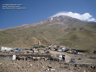
Mount Demavand Iran

4- Damawand Climb: Download
Damavand Poppy
Damawand Summer Climb

More in MDG
Travel photo, picture and image gallery center, travel tour organizer, iran mount federation camps & huts, travel persia, persia tourism guide info desk, adventure tour organizer, outdoor and adventure holiday activities in persia, mountain weather forecast, main source of info for Mt, leading mountain and eco outdoor organizer, find helpful info for how to climb, ascend, collection of mountain tour photo pics video, raise on.

Demavand climbing information, tips and tricks 2011. Best source of info for how to climb Damawand Iran. Winter ascends, ski mountaineering & snowboarding. Specialist in Persian hiking & trekking and mountaineering tour. Cultural and historical sightseeing zones tours. Protected wildlife zone photo & pictutre gallery.

Wallpapers 4 MDG27MAR11
Copyright © Mount Damavand Guide . All rights reserved.

21 March 2011

Damavand-Wallpaper3


Damavand Wallpaper 3
21 March 2011, by Sherppa

Happy Persian New Year
The Iranian new year called Novruz, begins on 21 March, the beginning of the greatest festival and holidays in Iran and surrounding countries. The Novrooz marks the first day of spring in the northern hemisphere. It usually occurs on the March 21 or the previous/following day of Gregorian calendar.


Download Wallpaper
Copyright © 2011 MDG. All Rights Reserved.
Download the standard size wallpapers 1024 x 768 in jpg format.

1- Damavand beautiful red poppies: Download

Damavand Poppy
Damavand and its beautiful red poppy field.

2- Climbing Demawand Iran: Download

Damavand Climbing
Climbing Damavand Iran.

3- Damavend old shelter and mew hut: Download

Damavand Camp3
Demavand Camp3 Bargah Sevom, the old shelter and the New Hut.

4- Demavand Camp3 Bargah Sevom: Download

Damavand Camp3 Bargah Seveom
Damawand Camp3 Bargah Sevom old shelter view from New Hut.

More in MDG
Travel pics, photo, photos, foto, picture, pic , image google satellite, video gallery, pictures gallery, photo center, hobby digital photography and digital cameras, camera phones, Damavand guide, the main source of info for climbing Mt Damavand, hiking trekking and mountaineering tours 2011, leading mountain, eco and outdoor tour organizer in Iran.

Damavand, hiking, trekking, tour, tours, photo, picture, route, map, climb, climbing, ski, snowboard, mount, mountain, volcano, trip, travel, weather forecast, elborz mountain trek/skiing 2011, trek tour iran summer, alborz & zagros trekking and mountaineering, hot spring, travel tour organizer.

Climbing damavand iran, alborz and zagros mountains hiking trekking tour 2011, mountaineering federation resorts and camps, travel tour persia, persian tourism mountaineering guide, best adventure tour organizer, outdoor and sightseeing activities in persia, adventure holiday, mount weather forecast.

Wallpapers 3 MDG21MAR11
Copyright © Mount Damavand Guide . All rights reserved.

18 March 2011

Damavand-Wallpaper2


Damavand Wallpaper 2
18 March 2011, by Sherppa

Download Wallpaper
Copyright © 2011 MDG . All Rights Reserved.
Download the standard size wallpapers 1024 x 768 in jpg format.

1- Damawand Beautiful lenticular Cap Cloud: Download

Damavand Base Camp
Damavand Beautiful lenticular Cap Cloud

2- Damawand Mountain: Download

Damavand
Damavand Mountain

3- Demavand Base Camp and lenticular Cap Cloud: Download


Damavand Base Camp
Damavand Base Camp and lenticular Cap Cloud

4- Deamavand Camp3 Bargah Sevom New Hut: Download


Damavand Camp3 Bargah Seveom New Hut
Damavand Camp3 Bargah Sevom New Hut

More in MDG
Damavand wallpapers for mobile phone, desktop wallpapers and backgrounds, background slideshow, photo gallery, photography, photo album, picasa web album nature category wallpaper, free demavand wallpapers. Technical info for safe ascends to summit. Raise your climbing skills on mountain. Specialist in guided tours and climbs. Photo gallery. Mt picture gallery, trip report, route up map, winter climb and ski mountaineering.

Tehran Mount federation hut coordinates gps, how long does it take to climb the zagros mountains, how high is mt alborz, historic caves in iran, recovery from acute mountain sickness, elevation of mountains around tehran, why is weather important during mountain climbing, sightseeing activities in tehran, volcano range in middle east. Expedition damawand iran, solo winter climbing advice, october, november, december, january, february, march, climbing demawand april, may, june, july, august, september, october.

Mountain photo picture and video. Hiking trekking and climbing tour Damavand. Winter climb and ski touring Tehran. Outdoor activities, eco sightseeing Shiraz. Desert, silk road and nomad tour Persia. World heritage sites,cultural and historic tour Persia.

Wallpapers 2 MDG18MAR11
Copyright © Mount Damavand Guide . All rights reserved.

16 March 2011

Damavand-Wallpaper


Damavand Wallpaper 1
17 March 2011, by Sherppa

A collection of high quality wallpaper pictures featuring Mt Damavand, Alborz Mountains, nature, landscape, flowers and travel photos. Source for original Damavand desktop slideshow, cool wallpaper and photo gallery from the nature category. In this series of wallpaper posts, you can download free desktop wallpapers and high resolution desktop backgrounds. Download for your personnal use .

All Rights Reserved. © 2011 MDG
All the material on our websites and weblogs are protected by copyright. No part of the site may be published, reproduced, stored or transmitted in any form without prior written permission. You may use the maps for personal use only.


Download Wallpaper
Download the standard size wallpapers 1024 x 768 in jpg format.

1- Mt Damawand Poppy: Download

Damavand
Damavand Poppy, South Route

2- Damavand Mountain Base Camp: Download

Wallpaper Damavand
Damawand Mountain, Base Camp

3- Demavand Base Camp Poppy Field: Download

Wallpaper Damavand Iran
Demavand Base Camp Poppy Field

4- Polour Village: Download

Damavand
Polour Village near Damawan Iran

More in MDG
Download Damavand wallpapers to your mobile cell phone, desktop wallpapers and backgrounds, standard background, desktop slideshow, cool wallpaper, photo, photos, photo gallery, photograph, photographic, picture pic, image album, digital art, skin art, themes, wallpaper art, traditional art, wallpaper from the nature category, download free demavand wallpaper. Mt picture gallery, trip report, route up map, winter climb and ski mountaineering. Technical info for safe ascends to summit. Raise your climbing skills on mountain. Specialist in guided tours and climbs. Photo gallery.

Iran mountain tour photo picture and video gallery. Hiking trekking, mountaineering and climbing tours 2011 Damawand. Winter climb, ski touring and snowboard guided tour Iran mountains. Outdoor activities, ecological system, sightseeing and landscapes of Iran. Desert safari tour, silk road and camel riding and nomad tour Persia. Persian world heritage sites, cultural and historic touring and tourism. Ski touring in major ski resorts in Alborz and Zagross Mountains Iran.

Wallpapers MDG17MAR11
Copyright © Mount Damavand Guide . All rights reserved.

11 March 2011

Damavand-Maps


Damavand Maps 5
11 March 2011, by Sherppa

Useful Road and Route Maps for South Face
Updated new edition includ full size maps for download free of charge.

In this topic you can find useful maps and download the full size images in jpg format, the maps show you the best possible footsteps and you can discover how to go to mountain and reach the peak particularly if you intend to go for a solo climb.

About the South RouteClasic south route is the most popular side of the mountain and many mountaineers prefer to climb from this side due to its mild climbing slop, good shelters and huts and easy accessibility from Tehran. The recommended starting point is Camp1 Polour Hut.

How to go to DamawandIKA or Mehrabad Airport Tehran> Haraz Road >Camp1 Polour> Camp2 Base> Camp3 Bargah Sevom> Summit.

All Rights Reserved. © 2011 MDG
All the material on our websites and weblogs are protected by copyright. No part of the site may be published, reproduced, stored or transmitted in any form without prior written permission. You may use the maps for personal use only.


Download Maps
Download the full size images in jpg format.
1- Damawand Map: Download

Damawand Map
Damawand Map

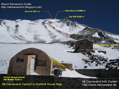
2- Camp3 to Summit: Download
Damavand Mountain Map
Camp3 to Summit Trail Map
South Face Demavand

3- IKA or Mehrabad Airport Tehran To Mt Demavand Road Map: Download

Airport to Damavand Mountain Map
IKA or Mehrabad Airport Tehran To Mt Damavend Road Map

4- Tehran To Mt Demavand: Download

Tehran To Mt Damavand Road Map
Tehran To Mt Demavand Road Map


More in MDG
Damavand hiking & trekking route and trail maps, distance tehran to demavand, iran tour organizer, mountain guide, tour 2011 damawand, hiking & trekking iran mountains, caltural touring and tourism, nature adventure tour, climbing expedition and trekking tours, travel tour agency, travel guide, how to climb classic south damawand, ski mountaineering and snowboarding tour iran. Hiking trekking tours mt Demavand Iran, photo, picture gallery, trip report, route up map, winter climb and ski mountaineering.Technical info for safe ascends to Mt Damavend summit. Raise your climbing skills on Damawand Iran. Specialist in guided tours and climbs. Hiking trekking tours 2011. Photo gallery. نقشه راه، نقشه راه کوه دماوند، نقشه جاده دماوند.

Maps MDG11MAR11
Copyright © Mount Damavand Guide . All rights reserved.

09 March 2011

Damavand-Map


Damavand Maps 4
9 March 2011, by Sherppa

South Face Road and Route Maps 2
In this topic you can find some interesting Google Earth maps and download the original size in jpg format, the maps gives you an idea about your way and distances from capital city Tehran to the starting point and first camp to the summit, it will guide you the correct bearing especially if you use it with a handheld gps receiver.

Remember south face is the most recommended route of this mountain, and the suggested starting point is Camp1 Polour Hut. The maps in this topic are useful for ascending from south face from Camp1 Polour to the summit.

How to go to Damavand
Tehran> Haraz Road> Polour Village > Polour Camp> Base Camp> Bargah Sevom Camp> Summit.

All Rights Reserved. © 2011 MDG
All the material on our websites and weblogs are protected by copyright. No part of the site may be published, reproduced, stored or transmitted in any form without prior written permission. You may use the maps for personal use only.


Download Maps
You may download maps in jpg format
(made by Google Earth)

1- Tehran to Camp1: Download

Tehran To Damavand First Camp Map
Tehran To Polour Village Road Map

2- Camp1 to Camp2: Download
Gravel Road, by car in summer or walk in winter.

Damavand Mountain Map
Camp1 Polour to Camp2 Base Map
South Face Damawand

3- Camp2 to Camp3: Download

Damavand Mountain Map
Camp2 Base to Camp3 New Hut Map
Damavand Iran

4- Camp3 to Summit: Download
Camp3 Bargah Sevom Old Shelter or the New Hut to the top.

Damavand Mountain Map
Camp3 to Summit Map
South Route Damawand
(Green line for ascend, red line for descend)

More in MDG
Google maps and google earth, route and trail karte, peak map summit, google satellite mappa, image south route, distance tehran to damawand, mountain map, elevation of alborz mountain in iran, gps tracking, track file, handheld gps receiver, descend from the summit, climbing slope Карта, satellite tracking karta, mountaineering elborz mountains harita, ski mountaineering and snowboard, gps tracker in iran, persian camp3, how long does ittake to climb the zagros mountains, gps landmark waypoint iran, travel guide, alburz exped, tehran hiking elevation.

Best organized tours of iran, iran mountaineering guide, lout desert hike, dasht e kavir treking, ancient silk road elburz mountains, climbing and ski tour, iran trecking itinerary, guided tour 2011 damavand iran, hiking & trekking 2011 iran mountain, mount demavend June, july, august, mountain tourisminfo center, iran mount climbing federation, ski federation resorts, iran climbing federation, mountain caves kurdistan, mountaineering gear list, encyclopedia of iran mountains, iran local guide, outdoor tour organization, mountain tours 2011, adventure mountain climbing and eco tour guide, tour demavand 2011, historic ski and eco tour.

Touring and tourism, nature and adventure tours, ski touring, trekking tours, travel and tour agency, travel guide, vacation tour, photos, picture, image, photographic,satellite pictures damawand basecamp, photo gallery foto, zagros mountains weather forcast, haraz road mapa, forecast iran summit, alborz weather september november december, iranian mountain mythology, meteorology iran mountain climing, weather and climate haraz, winter temperature, demavand météo. adventure tour alborz mountains, camps info, attractions of iran, mountaineering federation iran, association organization society, south route gps measurment.

Hiking trekking and mountaineering route and trail map. Randonnée pédestre et l'itinéraire d'alpinisme et carte des sentiers. Wandern Trekking und Bergsteigen Route und Wanderkarte. Fotturer trekking og fjellklatring rute-og løypekart. Trekking e caminhadas rota de montanhismo e mapa da trilha. походы походы и альпинизм маршрута и след карту. Senderismo senderismo y rutas de montaña y el mapa de ruta.

Climbing expedition, hiking & trekking and climbing tour, mountain camps, expedition map iran, how to go, how to reach, how to climb, classic south route to top, technical info, virtual trip by google earth, mountain guidebook, travel guide, multi-day backpacking mount trips, hiking guide book, facts and figures, virtual tour by google earth, distance tehran to damavend, mountain shelters and huts, ski mountaineering tour iran, route and trail satellite image, technical info for safe ascends to summit, raise your climbing skills. specialist in guided tours and climbs, trip report, winter climb and ski mountaineering, نقشه راه، نقشه راه کوه دماوند، نقشه جاده دماوند.

Maps MDG09MAR11B
Copyright © Mount Damavand Guide . All rights reserved.

01 March 2011

Damavand-GPS


GPS Tracks
1 March 2011, by Sherppa

GPS Tracks for south route Mt Damavand Iran
GPS track is a useful data file which is recorded by a GPS receiver or a GPS tracker by using the Global Positioning System satellites, it helps and guides you to find the exact position of a path/track. It includs data such as time, speed, coordinate, (latitude, longitude) and altitude, it could be in different formats such as GPX, CSV, KML, KMZ ...You may convert it to your desired format by softwares like GPSBabel.

South Route GPS Track Damavand
Camp3 to Summit GPS Track, Damavand South Route
(Green line for ascend, red line for descend)

The data can be stored in a (handheld) gps device or a pc to show or simulate the exact location of a route/person to be displayed against a map backdrop when analysing the track.

Here you can download these useful GPS tracks files which assist your Damavand expedition, especially if you intend to explore the mountain without guide and by yourself only, these tracks help you the best footprints and footsteps

You can uploaded files to your gps device to determine your precise direction, or use it in google earth to see the tracks or to simolate the climbing, specially in case of bad weather and foggy condition, it helps to find the way and save your life.

The GPS Tracks in this topic is for climbing from south face through Camp1 Polour to the Damavand summit.
ie Camp1 Polour> Camp2 Base> Camp3 New Hut> Damavand Summit.

Remember, the clasic south route is the most recommended route to ascend Damavand and the best starting point is Cam1 Polour Hut.

Download GPS Track Files
For South Route in GPX Format
By Garmin Oregon 550 handheld gps navigator
(To save battery, some tracks are recorded when comming down!)

1- Track Camp1 to Camp2: Download
Track Gravel Road, by car in summer or walk in winter.

2- Track Camp2 to Camp3: Download

3- Ascend Trak Camp3 to Summit: Download
Climb from Old Shelter or New Hut to Mt Damavand peak.

4- Descend Track Summit to Camp3: Download
Return from top to Campsite3
Read more about this gps track in GPS Track 2

Visit also: GPS Landmark.

Damavand Mountain GPS Track
Camp2 Base to Camp3 New Hut GPS Track
South Route Damavand Iran


Damavand Mountain GPS Track
Camp1 Polour to Camp2 Base GPS Track
South Face Damavand Iran

More in MDIC
GPS tracking unit, track log data, the tracklist, gpx, kml format, g.p.s. track files, handheld g.p.s. receiver, descend from the summit, climbing slope, guideposts, g-p-s tracking systems, google maps and google earth, continuous tracking, navigation equipment, handheld g.p.s. receiver, live g.p.s tracking, satellite tracking system, g.p.s. tracking systems, mountaineering elborz and zagross mountains, ski mountaineering and snowboard tour, g.p.s. peak, map summit, google satellite, image, climbing tours, fake summit south route.

Expedition guided tour 2011, guide damavand iran, climbing and ski tour damavand iran 2011, hiking & trekking tours 2011, iran mountain federation, ski season and ski guided tour, route and trail map, desert and eco nature trekking, mount tourism info center, mount climbing federation iran, ski federation resorts, distance from tehran to damavand, alborz mountain range map, photo, picture, image, photographic, satellite pictures damavand basecamp, best climbing time, mount guide, weather forecast, winter temperature, demavand weather météo.

GPS Tracks MDG01MAR11
Copyright © Mount Damavand Guide . All rights reserved.

Best Mount Damavand Climbing Experience with Local Guides

  Best Trekking & Ski Youring Guides in Mount Damavand’s Adventure The Role of Certified Guides in Mount Damavand’s Unique Adventure. Th...