Showing posts with label GPS. Show all posts

16 July 2011

Damavand-GPS-Track


Damavand GPS Tracks
16 July 2011 By Sherppa

Tehran IKA Int Airport to Polour Camp GPS Track and Road Map
Download useful GPS tracks in GPX format and road map in JPG format which will show the way to the Camp1 Polour with the help of a hand held gps receiver. This GPS track is useful for ascending either from south face or the west route of Mt Damavand. The track will guide you to the correct direction and show your distances from IKA Airport to the first camp. Remember the best starting point is Camp1 Polour Hut.

How to go to Damavand
IKA Airport>Tehran> Damavand Road> Haraz Road>Polour Camp

Download GPS Track in GPX format
IKA Airport to Camp1 Polour: Download

Download Full Size Map in JPG format.
IKA Airport to Camp1 Polour: Download

More Useful GPS Tracks.

All Rights Reserved. © 2011 MDG
All the material on our websites and weblogs are protected by copyright. No part of the site may be published, reproduced, stored or transmitted in any form without prior written permission. You may use the GPS Tracks for personal use only.


IKA Airport To Damavand First Camp Road GPS Track and Map
IKA Airport Tehran To Polour Camp GPS Track and Road Map
By Ardeshir Soltani

More in MDG
Best season for climbing tour Damavan Iran. What equipment needed for climbing. Damawand home page. Small tour to iran for seniors. Skiing Demavend Mountain. Damavend summer and winter trek tours. Touring to the nature of iran. Poppies bloom iran. Flora and fauna in shahmirzad. Damawand summit, peak, top photoes. Damavand tour, tourism and travel, tour agency. Best tour images of peak of the mountain. High definition images of Demavand. Best mountain to ski down in iran. Mt Tochal gondola lift. Grass skiing.

Elburz mountains ascends. Average temperature and weather forecast. GPS logs iran mountains, Garmin gps waypoints. Damavand ascend route topo map and GPS tracks, topo gpx files, gpx files. Mountaineering track on gps, Tehran gps map kmz. Coordinate barghah-e-sevom shelter and summit, climbing gps routes. Best gps for mountaineering. Iran local trekking guides Ardeshir Soltani. Iranian Hiking Climbing Federation, Mountaineering Federation campsites and huts. Diamox recommended for prevention of ams.

New hut made by climbing federation in iran. Damavand climbing...how many days required. What is the ranking of mount Damawand in the world. Can you see the Caspian Sea from summit. Tour trip price, guide cost, trekking expenses and climbing and trekking permit Damavend. How can go with my car from tehran to the mountain. Cheap camping tents. Wool sleeping full face mask. Volcanoes in the middle east. How much silica is in, what type of rock does Damawand have? Geological surrounding and flora of mount damavand. Mineral water baths in iran.

Boday treatments natural spa springs iran. Shuttle coach Tehran IKA Airport to Dizin ski resort. Fun facts, intresting facts Dizin ski resort. Ski accessories in tehran. Mountain touring in iran. Map of alborz mountains download. Reyneh town iran, ski hill. Pictures of earth, mountain and sea, phot vignettes of iaranian natural caves. Find all useful info for trekking Damavand Mountain.GPS track files. Iran Mount climbing federation huts and campsites.Best time, season and climbing period for Mt Damavand. Necessary info for hiking trekking and climbing. Ascend to the summit with the most experienced Iranian mountain guides. climb, hike, trek, tours, photo, picture, route, map, ski, snowboard, mountain, gps, volcano, trip, travel, weather.

Damavand GPS Track MDG16JUL11
Copyright © Mount Damavand Guide . All rights reserved.

14 May 2011

Damavand-GPS-Tracks


Damavand GPS Tracks
14 May 2011 By Sherppa

Tehran to Polour Road GPS Tracks
Find useful GPS tracks and download it in GPX format which will help you to go to the mountain with the help of a hand held gps receiver. It will guide you the correct bearing and gives you an idea about your distances from Tehran to the first camp. Remember the most common starting point is Camp1 Polour Hut. This GPS track is useful for ascending either from south face or the west route.

How to go to Damavand
Tehran> Damavand Road> Haraz Road> Polour Village> Polour Camp

All Rights Reserved. © 2011 MDG
All the material on our websites and weblogs are protected by copyright. No part of the site may be published, reproduced, stored or transmitted in any form without prior written permission. You may use the GPS Tracks for personal use only.


Download GPS Track in GPX format
Tehran to Camp1: Download

Download Full Size Map in JPG format.
Tehran to Camp1: Download

More Useful GPS Tracks.

Tehran To Damavand First Camp Road GPS Track
Tehran To Polour Camp Road GPS Track

More in MDG
Read all the necessary info for climbing Mt Damavand Iran before you go. What equipment needed for climbing. GPS for mountaineering for Elburz mountains ascends. Touring to the nature of iran. Flora and fauna on Mt Damawand. Barghah-e-sevom shelter.Mountain climbing federation Iran shelters. Iran mountain federation, mountain climbing federation campsites. Mountaineering federation, climbing federation, ski federation resorts. Persian hiking groups, nature society tehran, mountaineering groups.

Iran mountain association. Logistic for ski and tour kit list. The challenges of Iran mountain climbing. Does Iranian mountains get alot of avalanches. Elevation of the highest mountain in Alborz Ranges. Recovery from acute mountain sickness, AMS recovery. Why is weather important during mountain climbing. Sightseeing activities tour organizer in tehran.

Experience of scaling the mountain that is a 5,671m high volcano in Iran. Best time, season and climbing period for Mt Damavand are June, june, july and august. The challenges of climbing Damawand in september, october. Hiking & trekking guide tour 2011 iran. Facts, figures and statistics Demavand Mountain. Why is weather important during mountain climbing. How long does it take to climb the Alborz and Zagros mountains.

Find the necessary info for hiking trekking, hike, trek, tour, tours, Iran, photo, picture, route, map, ski, snowboard, mount, gps, volcano, trip, travel, weather, mountaineering and climbing Damavand Iran. Ascend to the summit with the most experienced Iranian mountain guides.

Damavand GPS Track MDG01JUN11
Copyright © Mount Damavand Guide . All rights reserved.

01 March 2011

Damavand-GPS


GPS Tracks
1 March 2011, by Sherppa

GPS Tracks for south route Mt Damavand Iran
GPS track is a useful data file which is recorded by a GPS receiver or a GPS tracker by using the Global Positioning System satellites, it helps and guides you to find the exact position of a path/track. It includs data such as time, speed, coordinate, (latitude, longitude) and altitude, it could be in different formats such as GPX, CSV, KML, KMZ ...You may convert it to your desired format by softwares like GPSBabel.


South Route GPS Track Damavand
Camp3 to Summit GPS Track, Damavand South Route
(Green line for ascend, red line for descend)

The data can be stored in a (handheld) gps device or a pc to show or simulate the exact location of a route/person to be displayed against a map backdrop when analysing the track.

Here you can download these useful GPS tracks files which assist your Damavand expedition, especially if you intend to explore the mountain without guide and by yourself only, these tracks help you the best footprints and footsteps

You can uploaded files to your gps device to determine your precise direction, or use it in google earth to see the tracks or to simolate the climbing, specially in case of bad weather and foggy condition, it helps to find the way and save your life.

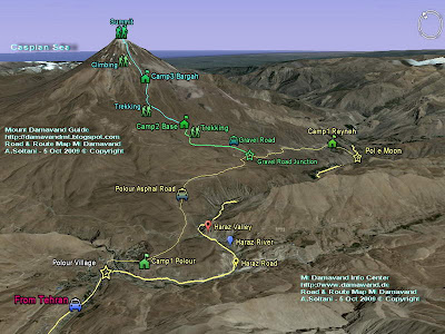
The GPS Tracks in this topic is for climbing from south face through Camp1 Polour to the Damavand summit.
ie Camp1 Polour> Camp2 Base> Camp3 New Hut> Damavand Summit.

Remember, the clasic south route is the most recommended route to ascend Damavand and the best starting point is Cam1 Polour Hut.

Download GPS Track Files
For South Route in GPX Format
By Garmin Oregon 550 handheld gps navigator
(To save battery, some tracks are recorded when comming down!)

1- Track Camp1 to Camp2: Download
Track Gravel Road, by car in summer or walk in winter.

2- Track Camp2 to Camp3: Download

3- Ascend Trak Camp3 to Summit: Download
Climb from Old Shelter or New Hut to Mt Damavand peak.

4- Descend Track Summit to Camp3: Download
Return from top to Campsite3
Read more about this gps track in GPS Track 2

Visit also: GPS Landmark.

Damavand Mountain GPS Track
Camp2 Base to Camp3 New Hut GPS Track
South Route Damavand Iran


Damavand Mountain GPS Track
Camp1 Polour to Camp2 Base GPS Track
South Face Damavand Iran

More in MDIC
GPS tracking unit, track log data, the tracklist, gpx, kml format, g.p.s. track files, handheld g.p.s. receiver, descend from the summit, climbing slope, guideposts, g-p-s tracking systems, google maps and google earth, continuous tracking, navigation equipment, handheld g.p.s. receiver, live g.p.s tracking, satellite tracking system, g.p.s. tracking systems, mountaineering elborz and zagross mountains, ski mountaineering and snowboard tour, g.p.s. peak, map summit, google satellite, image, climbing tours, fake summit south route.

Expedition guided tour 2011, guide damavand iran, climbing and ski tour damavand iran 2011, hiking & trekking tours 2011, iran mountain federation, ski season and ski guided tour, route and trail map, desert and eco nature trekking, mount tourism info center, mount climbing federation iran, ski federation resorts, distance from tehran to damavand, alborz mountain range map, photo, picture, image, photographic, satellite pictures damavand basecamp, best climbing time, mount guide, weather forecast, winter temperature, demavand weather météo.

GPS Tracks MDG01MAR11
Copyright © Mount Damavand Guide . All rights reserved.

05 January 2011

Dizin-GPS-Track


GPS Track 4
Tehran to Dizin Road Map, GPS Track & Waypoints.
Useful for Ski, Grass Ski, Snowboard and Mountaineering.
5 January 2011, Posted by Sherppa.

Dizin is the the most famous ski resort, the largest piste and the best winter sport center of Iran. Located near Chalous Road in the north west of Tehran in Alborz Mountain Range, it is also the famous grass-ski centre for summer sport activities. This resort is the best place for parctice and acclimatization for skiers before trying the giant Damavand peak.
Targeted Activities: Skiing, Snowboarding, Grass Ski
Read more info for Disin Resort.


Google Map Tehran to Dizin Ski Resort
Map by MDG

Geographical Location and Coordinate
Dizin
Base Altitude: 265m - 3600m
Latitude: 36-02-57 N (36.050316 N)
Longitude: 51-25-02 E (51.417953 E)

Tehran Starting Point:
(Tehran, Resalat Highway, Mosala Metro Station).
Latitude: 35-44-25 N
Longitude: 51-25-35 E

Download
Tehran to Dizin Road Map & GPS Track File
(by Garmin Oregon 550 Navigator)

Dizin Ski Resort Map in JPG Format: Download
Print friendly Google Earth Road Map.

GPS Track in GPX Format: Download
Useful for most handheld GPS receivers.

GPS Track in KMZ Format: Download
Useful for Google Earth.

Quick Facts
Tehran to Dizin by Car
Distance ( Cartographic Length ): 126 km
Average Speed: 45 km/h
Maximum Speed: 120 Km/h
Total Time: 02:45

How to go to Disin
The only access to the resort is by road. You may reach the area by two differnt road, the first one is longer but a safer way.

Via Chalus (Chaloos) Road 126 km
1- Tehran> (Resalat Highway, Mosala Metro Station)> Tehran-Karaj Highway> Chalous Road> Dizin junction> Dizin Resort.
Or
Via Shemsak Road about 55 km
2- Tehran> (Resalat Highway Baqeri Junction)> Tehranpars 4th Sq.> Gardaneh Ghochak> Lavasanat> Oshoun Fasham Road> Shemshak City> Dizin Resort.

Winter Warning
- Dizin is only accessible by road, after a heavy snowfall, snow chains are necessary for cars.
- The road between Shemshak and Dizin which is about 12 km long may be closed in winter after a heavt snow due to avalanch risk.
- In bad weather and stormy condition, bad visibility or darkness, it is not safe to ski without a reliable navigation unit like a handheld GPS receiver.

Related Topics:
GPS Tracks for Mt Damavand Iran.
GPS Tracks for Shemshak Ski Resort.

Dizin Ski Resort GPS Map
Google Map Tehran to Dizin Ski Resort

More in MDG
Ski and snowboard resorts for winter sports iran, transport from ika international airport tehran to dizin resort, tour 2011 damavand summit iran, tehran to disin GPS track and google earth map, peak coordinates, landmark, detailed ski resort information, grass ski tour guide, trek mountain expedition, tour, travel tour organizer, 4wd expedition, nature society tehran, trekking iran in winter, price for climbing iran mounts, natural national heritage site, skiing tochal area, damavand climb, tek, hike, mountaineering, tour guide 2011, iran ski federation resorts.

Mountain photo, picture, snapshot, image, photography, photographic, digital photos, images of nature, iranian winter, the east route of the volcano, the north face of the mountain, nandal, the south face of the sumiit, mount guided tour, mountaineering guides in iran, facts, maps, reyneh iran hot springs, iranian persian hiking groups, buying mountain clothes in tehran, piste koohrang, distance from tehran, interesting facts, climbing alborz mountain zone, tochal safety info, elborz mountain trek/skiing in winter 2011, cave ali sadr, google map, zagros ski mountaineering, travel from ararat in turkey to damavand iran, ski weather forecast tehran.

Dizin GPS track MDG05JAN11
Copyright © Mount Damavand Guide . All rights reserved.

01 January 2011

Shemshak-GPS-Track


Happy New Year!

GPS Track 3
Tehran to Shemshak Road Map, GPS Track & Waypoints.
Useful for Ski Mountaineering and Snowboarding.
1 January 2011, Posted by Sherppa

Shemshak ski resort is located in the middle of Alborz Mountains Iran, it is one of the best down hill track for wild ski mountaineering and freestyle snowboarding. It has excellent powder snowfall in winter, a suitable place for advanced skier and snowboard lovers before trying Damavand. It is the second largest piste in Iran after Dizin resort.
Targeted Activities: Cross-country Skiing, Ski, Snowboard.

Read more info for Shemshak Resort


Google Map Shemshak Ski Resort Tehran, Iran
Map by MDG

Geographical Location
Shemshak
Altitude: 2530m - 3050m
Latitude: 36-00-33 N (36.009192 N)
Longitude: 51-29-36 E (51.493492 E)

Tehran Starting Point:
(Tehran, Resalat Highway, Baqeri Junction, Baqeri Metro Station).
Latitude: 35-43-57 N
Longitude: 51-31-3 E

Download
Tehran to Shemshak Road Map & GPS Track File
(by Garmin Oregon 550 Navigator)

Shemshak Ski Resort Map in JPG Format: Download
Print friendly Google Earth Road Map.

GPS Track in GPX Format: Download
Useful for most handheld GPS receivers.

GPS Track in KMZ Format: Download
Useful for Google Earth.

Quick Facts
Tehran to Shemshak by Car
Distance ( Cartographic Length ): 43 km
Average Speed: 32 km/h
Maximum Speed: 90 km/h
Total Time: 01:30

How to go to Shemshak
You may reach the area by three differnt roads, the first one is shorter and a preferred way.
1- Tehran> (Resalat Highway Baqeri Junction)> Tehranpars 4th Sq.> Gardaneh Ghochak> Lavasanat> Oshoun Fasham Road> Shemshak.
2- Tehran, Afsarieh Highway> Yasini Highway> Telov Road> Lavasanat> Oshoun Fasham Road> Shemshak City.
3- Tehran-Karaj Highway> Chalous Road> Dizin junction> Dizin Resort> Shemshak Road> Shemshak Resort.

Winter Warning
- Shemshak City is only accessible by road, after a heavy snowfall, snow chains are necessary for cars.
- The road between Shemshak and Dizin which is about 12 km long is usually closed due to avalanch risk.
- In bad weather and stormy condition, bad visibility or darkness, it is not safe to ski without a reliable navigation unit like a handheld GPS receiver.

Related Topics:
GPS Tracks for Mt Damavand Iran.
GPS Tracks for Dizin Ski Resort.

Shemshak Ski Resort GPS Map
Google Map Tehran to Shemshak Ski Resort

More in MDG
Mountaineering damavand iran, tehran to shemshak GPS track and climbing map, gps coordinates, peak waypoint and landmark, google map, google earth, winter climbs and mountaineering tour 2011, garmin gps navigator, GPS tracking system, skiing season in dizin and shemshak resorts, ski tour guide and touring, mount guide, expedition, mount weather forecast, damavand tour 2011, skipiste, adventure tour info, trekking and climbing tours, travel gps map, ski tour 2011, iran natural attraction tours, tour organizer, volcano activity demavand, rivers and lakes in iran, where is mount damavand iran, off piste skiing, downhill skiing, cross country skiing, snowboarding, people, snow sports, iran winter sport.

Resort shemshak in alborz mountains, planet images, photography, images and photo iran, most recent eruptions, skiing in winter, ski season, domavand montain in iran, damawand messner, winter climb demawand, damawand koh, bargahe sevom, damavend skitouring, skitour dizin and darbandsar, climbing mount damawand permit, americans mt demavand, dizin cottage, damavend winter climb, damawand sherppa, iran damawand weather, photo, picture, snapshot, image produced by photographic for mount in iran, permission required to climb mount demavand iran, first person to climb mt. damavend, garmin map, climb mt. damawand, tehran demavand distance, best season climbing mt damavand.

Shemshak GPS track MDG01JAN11
Copyright © Mount Damavand Guide . All rights reserved.

27 November 2010

Damavand-GPS-Track


GPS Track 2
Useful for Mountaineering, Ski and Snowboard
27 November 2010 Posted by Sherppa

There is a descend (return) route on the south face of Damavand Mountain called Shen Ski (soft type of soil), it is a comfortable way to go down especially for tierd mountaineers who return from a tough climb, also it is the best down hill track for wild ski mountaineering and freestyle snowboarding.

This descend route is located between Damavand summit 5671m and the Camp3 New Hut 4250m, the covered area has a mild climbing slope without rocks and guideposts, it is the easiest return way of the mountain, in good visibility you can find your way back easily.

This GPS track file is ideal for:
A- Descend in Summer
Climbers who have summited successfully and prefer an easier way down to avoid rocky parts, suitable when the valleys are free from ice and snow and the the ground is covered with soft sands.

Please remember this track is slightly different from ascend route and is not recommended for climbing up! It is suitable for descend only. (The green line on the following map shows the ascend track).

B- Ski Mountaineering and Snowboarding in Winter
The best track for Ski Mountaineers and snowboard lovers to enjoy 3000 meters long distance and 1400 meters altitude downhill ski in snow during the winter and go down from the peak to campsite3.

Shen Ski GPS Track File in GPX Format
(Damavand summit to Camp3 New Hut)
by Garmin Oregon 550 Navigator
Download

Warning
In bad weather and stormy situation, poor visibility or darkness, it is not safe to go upper than the fake summit 5400 meters without a reliable navigation unit like a handheld GPS receiver.

Visit Also:
GPS Tracks for Mt Damavand Iran.
GPS Landmarks.


Damavand Mountain GPS Track
GPS Tracks Mt Damavand Itan


South Route GPS Track Damavand
Mt Damavand South Route GPS Track

More in MDG
Damavand iran, how to climb, warning for mountaineering, equipment list, trail and climbing map, gps coordinates, way point to the peak, google map, google earth satellite image, damavand volcano winter climbs and ski mountaineering tour 2011, Garmin Oregon 550 Navigator, GPS satellite tracking system.

Continuous tracking,damavand climbing and ski season iran, dizin and shemshak ski resorts iran, local ski tour guide, ski touring, iran mountain and ski guide, ski expedition, mount tochal ski resort, how to hike in iran, how to get to the mountain, damavand weather forecast.

Damavand expedition tour 2011, ski resort and piste, touring information, adventure tours, hiking trekking, ski tour, climbing tours, travel map, guided tour 2011, sightseeing iran natural attractions, ecosystem tourism, touring organization, travel agency.

GPS Track Files - Descend MDG27NOV10
Copyright © Mount Damavand Guide . All rights reserved.

12 October 2010

Damavand-Iran-GPS-Track


GPS Track 1
Useful GPS Track File for Mt Damavand Danger Zone
12 October 2010 Posted by MDG

Danger Zone is an area which is located between the Fake Summit 5400m and the real Peak 5671m on the south face of Damavand. In an ordinerary weather and good visibility it is an easy part of the mountain, but in poor visibility and bad weather it is difficult part of the route.

The area is the most incident part of the mountain which many accidents has happened there, mountaineers lose their way easily when they return down from the summit due to bad visibility, darkness, stormy and violent weather.

GPS Track File in GPX Format
(by Garmin Oregon 550 Navigator)

This GPS track file is very helpful to show you the actual footprints up and down to safly pass through this dangrous zone, it could save your life, take care.

Track File Fake Summit 5400m to Summit 5671m (Danger Zone)
This track file is suitable for ascend and descend.
Download GPS Track

This area looks like a desert, without signs or rocks, it has a mild climbing slope with only few guideposts, you may not find the guideposts in bad visibility, you can ascend easily but you may not find your way back.

Warning
In bad weather, foggy condition and poor visibility, it is highly recommended not to go upper than fake summit without a reliable navigation equipment such as a handheld GPS receiver.

Visit Also:
GPS Tracks for Mt Damavand Iran.
GPS Landmarks.


Damavand Mountain
Danger Zone Damavand Mountain Iran
Photo by A. Soltani

Volcano Damavand
Google Earth Damavand Mountain

More in MDG
Common mistakes damavand volcano, difficulty and climbing grade, gps landmark, waypoint and traks, route and trail map footprints, climbing map, goog earth iran, gps tracking unit, the southern route, handheld gps receiver, how to climb damavand volcano, warning for foreign mountaineers, damavand weather forecast, bad weather fog and cloudy condition, climbing season, winter temperature, freezing temprature, winter climb and ski expedition iran, info avalanche and glacier, weather tehran iran. Damavand winter climb and ski mountaineering tour 2011.

Elborz and zargos mountain ranges, iran ski season, chelgard ski, dizin ski resort iran, local ski tour guide, ski tour damavand mountain, iran mountain ski guide, ski expedition elborz and zagros mountains, mount tochal ski resort, ski tocha, proper gear, difficulty reaching the summit in the winter, falls and avalanches, bad visibility due fog and cloud, fake peak volcano, the real peak, iranian climbers. The recorded location data is stored within our tracking unit at regular intervals using a Garmin Oregon 550 Navigator, Live GPS Tracking, Global Tracking Communication, GPS tracking systems, GPS satellite tracking system.

GPS tracking solutions, All-Weather GPS Tracker, Continuous Tracking, GPS tracking unitdamavand expeditions, avalanch incident in shemshak road, damavand volcano, google map of mount damavand, equipment list for climbing damavand volcano, damavand gps coordinates, route map gps landmark to damavand peak, google earth satellite image, google earth map, gps routing damavand, route up mt damarvand, sabalan gps, where to hike in iran, demavend track on google map, how to get to damavand, google landmark 2 gps, map of mount suleiman in the alborz mountains, haraz road map.

GPS Track Files for Danger Zone MDG12OCT10
Copyright © Mount Damavand Guide . All rights reserved.

07 August 2009

GPS


GPS
Mt Damavand South Route GPS Landmarks
Useful GPS waypoints and landmarks guide for your trip to Mt Damavand, specially in case of bad weather and foggy condition, it may save your life. If you want to climb from the south route the safest, best shortcut and the recommended way is:
Tehran > Camp 1 Polour > Camp 2 Base > Camp 3 New Hut > Summit
and return the same way back. If you have enough time and energy left ! You may also visit the beautiful Icefall of damawand at 5100 M .
Download this print frindly text file:
GPS Landmark Damavand South Route .


Damavand GPS South Route
Mt Damawand GPS Landmark Table South Route

GPS Landmark Route Map Damavand
Mt Damavend GPS Landmark Route Map

1- Terminal Shargh, Tehran East Public Coach Station.
A good place to find a car or a bus towards mt damavand.

Altitude 1314 m
Latitude 35-43-25 N
Longitude 51-31-07 E

2- Camp 1 Polour 2,270 m - 7,447 ft
A good place for your rest, when you travel to the mountain , it is a newly made Iranian Mount Federation Complex Camp.

Altitude 2270 m
Latitude 35-50-50 N
Longitude 52-03-36 E

Mt. Damavand South Route Camp 1 - Polour Altitude 2270 m
Mt Demavand Camp 1 - Polour Altitude 2270 m

3- Poul e Moon Junction ( optional )
This landmark is also useful to visit Poul e Moon Caves.
( if you travel from Tehran to Damavand , you do not need this landmark ) .

Altitude 1683 m
Latitude 35-53-25 N
Longitude 52-11-53 E

Mt Damavand Poul e Moon Caves, Photo by A.Soltani
Damawand Poul e Moon Caves

4- Camp 1 Reineh ( optional )
( if you travel from Tehran to Damavand , you do not need this landmark ) .

Altitude 2078 m
Latitude 35-52-58 N
Longitude 52-09-58 E

Mt Damavand South Route Camp 1 - Reineh Altitude 2078 m
Mt Demavand South Route Camp 1 - Reineh Altitude 2078 m

5- Gravel Road Junction 1
Winter staring point, start of gravel road to base camp , you may also start climbing to damavand from here, specially when it is imposible to use the gravel road by car because of snow and ice condition. If you travel either from Tehran (via polour camp) or north of Iran ( via Reineh town ) , you will come to this junction anyway.

Altitude 2458 m
Latitude 35-52-47 N
Longitude 52-07-16 E

Mt Damavand Winter Climb from Junction Gravel Road
Mt Damawand Winter Climb from Junction Gravel Road

6- Gravel Road Junction 2
turn right here to goto base camp.

Altitude 2778 m
Latitude 35-52-29 N
Longitude 52-06-13 E

7- Camp 2 Base 3,040 m - 9,973 ft
Base camp ( Farsi Name Gosfand Sara), there is a shelter , a mosque and a sheepfold . During summer you can find water and some food here , but I recommend to use your own. You may find mule and porter to carry your equipments to the next camp. Rember that in other seasons base camp is walkout and almost resticted . This camp is not suitable for use in summer , because it is too crowded and too dirty, for acclimatization you may use camp1 or Camp3 instead.

Altitude 3040 m
Latitude 35-54-10 N
Longitude 52-06-34 E

Camp 2 Base Mount Damavand
Mt Damawand Camp 2 Base 3040m

8- First Sign

Altitude 3172 m
Latitude 35-54-26 N
Longitude 52-06-23 E

9- Statues Ridge
Interesting place to take some photo of damavand volcanic statues.

Altitude 3247 m
Latitude 35-54-36 N
Longitude 52-06-19 E

Damavand Statues Ridge
Mt Damavand Statues Ridge

10- River 1
Seasonal river, it is usually dry in summer and coverd with snow in colder seasons.
( Second Sign - Cross the river to the left )

Altitude 3423 m
Latitude 35-54-53 N
Longitude 52-06-14 E

11- River 2
The same seasonal dry river.
( Third Sign - Cross the river to the right )

Altitude 3688 m
Latitude 35-55-18 N
Longitude 52-06-16 E

Damavand seasonal river
Seasonal River 2 Sign

12- Sang e Du Shakh
The lar Lake is visible from this place.( Forth Sign )

Altitude 4055 m
Latitude 35-55-42 N
Longitude 52-06-31 E

Damavand Sang e Du Shakh
Sang e Du Shakh

13- Camp 3 Bargah 4,220 m - 13,845 ft
Bargah Sevom Shelter is the last camp in the south route, during summer it is too crowded and in not suitable for use, you better bring and use your own tent for better comfort and privacy. You may find water, some food , rent tent and sleeping bag at this place in summer , but it is recommended to use your own equipments . A new camp is under construction in this area and will be ready in 2009.

Altitude 4220 m
Latitude 35-55-54 N
Longitude 52-06-30 E

Damavand Camp 3 - Bargah Sevom
Mt Demavand Camp 3 - Bargah Sevom 4220m

Camp 3 New Hut
This new hut is made at altitude 4250 m above sea level, near to the old shelter/refuge Bargah Sevom, it is one of the highest huts in the word and best resting place in the area.

Altitude 4250 m
Latitude 35 - 55 - 57 N
Longitude 52 - 06 - 32 E

Mt. Damavand Camp3 New Hut
Mt Damavand Camp3 New Hut

14- Beginning of First Ridge

Altitude 4531 m
Latitude 35-56-18 N
Longitude 52-06-36 E

15- End of first Ridge ( change ridge to the left )

Altitude 4912 m
Latitude 35-56-39 N
Longitude 52-06-32 E

Icefall ( optional )
ice fall of mount damavand GPS landmark 31 Aug 2007

Altitude 5100M
Latitude 35-56-48 N
Longitude 52-06-40 E

Damavand Icefall
Icefall of Mount Damavand at 5100m

16- Beginning of Sulphuric Area

Altitude 4947 m
Latitude 35-56-41 N
Longitude 52-06-30 E

17- Memorial Sign ( Late Mohsen Ghanbari )

Altitude 5080 m
Latitude 35-56-47 N
Longitude 52-06-32 E

18- Flat area sign post
You have about half an hour hard work from here !

Altitude 5232 m
Latitude 35-56-56 N
Longitude 52-06-35 E

19- Baam Jonobi, Fake Summit ,
also called Sang e P-e-s-t-a-n
Get ready for sulphuric smell of damavand !

Altitude 5400 m
Latitude 35-57-05 N
Longitude 52-06-37 E

Fake Summit Mt Damavand Baam Jonobi, Photo by A.Soltani
Mt Damavand Fake Summit

20- Last Sulphuric Hill

Altitude 5436 m
Latitude 35-57-08 N
Longitude 52-06-37 E

21- Beginning of Summit Rocks

Altitude 5562 m
Latitude 35-57-18 N
Longitude 52-06-41 E

22- Summit South Face
Congratulation you have done it ! This is summit , summit of Iran, summit of Middle East, top of highest volcano in Asia and Europe, peak of second highest volcano in the north hemisphere .
GPS landmark ( 6 June 2006 )

Altitude 5621 m
Altitude 5640 m (new GPS measurement on Friday 31 Aug 2007 )
Latitude 35-57-19 N
Longitude 52-06-37 E

Damavand summit of Iran & Middle East, Photo by A.Soltani
Damavand summit of Iran & Middle East

23- Highest Rock
Damavand South Face Summit in old all record is measured as 5,671 Meters - 18,605 feet

Altitude 5626 m ( 6 June 2006 )
Altitude 5645 m (new GPS measurement on Friday 31 Aug 2007 )
Latitude 35-57-19 N
Longitude 52-06-36 E

Mt Damavand Highest point, Photo by A.Soltani
Mt Damavand Highest Rock

You may also be intrested in these topics Google Earth and Maps .


Google Earth Mt Damavand


Maps and Signs for Mt Damawand


Longitude
the angular distance of a place east or west of a standard meridian,
especially the Greenwich meridian.

Latitude
the angular distance of a place north or south of the equator.
(latitudes) regions with reference to their temperature and distance from the equator

Note:
Regarding the height , I believe hand held GPS unit results are not so accurate to refer to as a reliable reference , and I think it worth to do some accurate measurements with some sophisticated equipments like advanced differential GPS on damavand . ( Last edited by Sherpa on 2 Sep 2007 )

More
Gps landmark, waypoint volcano damavand, distance tehran, facts and figures, how to climb, info route and trail map, google earthsouth route, technical info, virtual tour google earth, gps guide.

GPS Landmark 2 MDG880516B
Copyright © Mount Damavand Guide . All rights reserved.