damavand-danger-zone
Danger Zone
Mt Damavand South Route Danger Zone
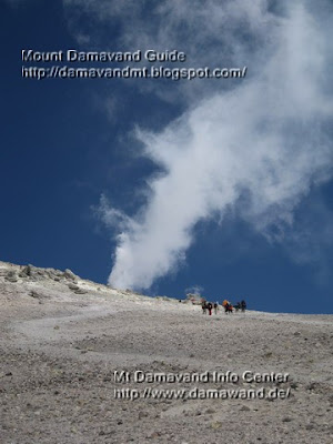
There is a dangrous zone on the south face of the mountain causing many death in bad Weather. This deadly area is between the fake summit 5400m and the real peak 5670m, it has been the most accident and casualty part of the southern route and the area where the most losses take place. Some beginner and even few famous Iranian climbers lost thier way and consequently their life in this area.
The area is without rocks, it has a mild slope with easy Difficulty and climbing grade, it is similar to a desert with no sign, there are only few guideposts in the area which you can not find them in fog and cloudy condition. You may consider it as the Bermuda Triangle of this mountain, but without the mysterious and supernatural events, it is a one way road ! you can ascend but you do not find your way back to the Camp 3 New Hut, the climber get lost when they return back from the Summit in this deadly zone.
The major cause of casualty in this area is bad weather and foggy condition, in a good visibility it is easy part of the mountain, in a bad visibility and without any particular Equipment it is possible to climb to the top, but impossile to find any sign, footprints and your way back to descend to the low camps and you may finish with a bitter end.

Mt Damavand Danger Zone
Photo by A.Soltani
Warning for Bad Weather
- Do not go upper than fake summit.
- Compass or a gps unit is necessary.
- An experienced mountain guide may be helpful.
GPS LandmarkThe danger zone stars from this point upto the summit, it is also the sulphuric area of the volcano.
Fake Summit
Altitude 5400 m
Latitude 35, 57, 05 N
Longitude 52, 06, 37 E
Fake summit alternate names:
Baam e Jonobi, Sang e Pes-tan, dood koh
Victims of Danger Zone in the recent years
Spring 2009
After their climb to the peak and on their way back, four climbers from Bandar Abas Province, Iran, lost their way to west ridge, three of them died and only thier leader survived.
The Victims:
- Torabi AbdulHamid
- Memari Farkhoundeh
- Keshmiri Sajedeh
Summer 2008
two climbers from Hamedan Province, Iran also after their climb, lost their way to east ridge, near Yakhar Glacers and died.
Spring 2002
Jalal Froozan Rabooki from Tehran, the most famous Iranian climber, lost his way back and had bitter end, his body was found 6 months later in Yakhar Glacers.

Damavand South Route Danger Zone
Photo by Ardeshir Soltani
More in MDG
Common mistakes in mt damavand climbing, difficulty and climbing grade, gps landmark and waypoint, mountaineering, how to climb, route and trail map, sulphur and volcanic activities, weather forecast, bad weather, winter climb, weather warning for foreign climbers, damavand weather, freezing temprature, climate, climbing season, facts, glacier, avalanche, how to climb, logitics for winter climb and ski expedition iran, timing, alert, warning, weather iran tehran, winter temperature, info avalanche and glacier, weather tehran iran, gps landmark, proper gear, wind chill, winter advice, safe retreat, mountain sickness, difficulty and climbing grade in winter, reaching the summit in the winter, info and support, equipment and gear, difficulty factors, disclaimer climbing can kill you, falls, avalanches, climbing map, google earth iran.
Danger Zone MDG31JAN10D
Copyright © Mount Damavand Guide . All rights reserved.
Labels: Danger Zone
<< Home