19 March 2023

Damavand Facts & Info

 Damavand Facts
Mount Damavand Facts. Informational facts, advice, and instructions for climbing Mount Damavand. All the information you need to know about Damavand, including statistics, information, weather predictions, hiking routes, climbing excursions around Damavand, necessary equipment, and more.

Mount Damavand Facts & Info
Damavand Facts & Info

Since Damavand is a conical volcano, there are four well-known hiking routes and numerous angles from which it can be climbed. Damavand Peak, which is frequently surrounded by clouds, is significant in Persian mythology and folklore. More than one of the nation's incredible natural wonders can be found in Damavand. In a clear sky, Tehran and as far as 250 kilometres away can both see the Damavand top. Another name for this enormous volcano in perfect cone shape is Damavand Volcano. It is situated on the southern shore of the Caspian Sea in the northern part of Iran, in the centre of the Alborz Mountain Range. The height of Damavand Mountain is 5670 meters above sea level (See also Damavand Height by our GPS Measurement). The Damavand Volcano is the second-highest volcano in the northern hemisphere and the tallest volcano in Asia.

Facts, Information and a guide for trekking in Damavand

Damavand Trekking Facts & Info
Facts, Information and a guide for trekking in Damavand
• Elevation Gain: 2670 meters (8760 feet).
Climbing Season: July through September is a prime trekking season.
• Best climbing itinerary: The best trekking itinerary is three to five days long.
• Best starting day: The best days to start are Saturday and Sunday. Visit Damavand Crowd.
• Best starting 
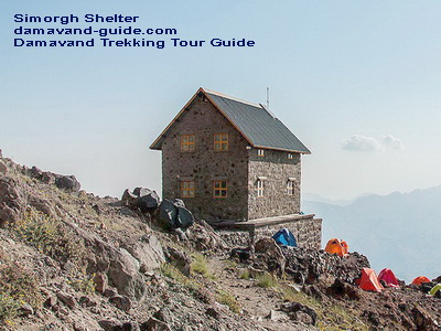
Damavand Campsites: Polour Campsite is the ideal starting point for the south and west routes. For the north and northeast routes, Nandal Camp.
• Climbing Season: All year long for seasoned climbers. From mid-June to mid-September is the best time for average climbers.
• Difficulty: Damavand's southern route difficulty is a considerable amount of uphill hiking.
• Easiest Hiking Path: In the summer, the southern path is a good place to go hiking and trekking.
• Moderate Trekking Route: The west path is an easy trek with a gradual ascent and a difficult descent.
• Longest Mountaineering Route: The longest mountaineering path is on the northeast side, along the Gazaneh trail.
• Hardest Climbing Route: The North Face is the most difficult scrambling climb.
• Hiking Distance: The base camp of the Goosfand-Sara South Way is about 8 kilometres from the summit (about 10 hours).
The conventional south path is the most well-liked route.
• Climbing Guide: The Damavand Guide Team is the most knowledgeable guiding team for trekking tours in Damavand.


Information and Facts for Trekking Tour Damavand


Detailed Information and Facts for Ski Touring Damavand
It depends on the weather and snowfall.

• Snow availability and ski season: December to mid-May. Skiing is most enjoyable in March and April.
• Best Ski Route: Damavand South Route Ski Resort is the best ski path.
• Best ski program: Seven-day ski itinerary.
• Snow Depths: 2 to 5 meters of snow cover
• Vertical Ski Drop: A maximum of 3000 meters can be skied vertically from the summit to the asphalt road.
• Total Skiable Distance: Peak to asphalt road distance is best around 12000 meters for total skiable distance.
• Ski Guide: The Damavand ski guide team is the most knowledgeable guiding team for ski touring and ski climbing.


Facts about Iran's Mount Damavand


Facts about Iran's Mount Damavand in Brief
Informational facts, advice, and instructions for climbing Mount Damavand.

• Height: 5,670 m (18,600 feet) (see my GPS measurement).
• Listing: It is listed in the Seven Volcanic Seven Summits (V7S).
• Location: Mazandaran Province, Iran.
• Mountain Chain: Alborz Mountains.
• Prominence: : 4,667 m. It is recognized as the world's 12th most prominent summit.
• Routes: There are four major Damavand trekking routes: the north route, the west front, the south route and the north-east side
Volcanic activity: It currently possesses thermal springs at the base and releases sulfuric gas from its summit.
• Peak location: Latitude and longitude coordinates, Lat: 35.954466°, Lon: 52.110020°.
• Nearest airports: IKA Airport and Mehrabad Airport.
• Last eruption: Around 5,300 BC was the last eruption.
• Symbolism: Damavand Mountain represents Iranian resistance to foreign occupation in Persian poetry and literature.
• Rank: The Damavand volcano is the third-highest of the volcanic seven summits (V7S). It is also the tallest mountain in Iran and the middle-east, the second-highest mountain in the northern hemisphere, and the tallest volcano in Asia. In terms of prominence, Damavand Mountain is the world's 12th-highest summit. 

Damavand Facts 23MDG0319A

13 March 2023

Damavand Ski

Difference Between Damavand ski touring and ski mountaineering!

Why is Damavand ski touring different from Damavand ski mountaineering?
Understanding the many types of skiing, ski touring, and ski mountaineering vacations in Damavand Ski Guide. Ski touring and ski climbing are available in the Iranian highlands. The Damavand ski touring and ski mountaineering skills are used for backcountry skiing in unmarked or unpatrolled isolated terrain. Ski mountaineering is more challenging and dangerous, and it requires more knowledge and equipment. The primary difference is that Damavand ski mountaineering has more difficult terrain, such as steep slopes, glaciers, rocks, and ice that must be traversed by skis.


Alpine skiing in Damavand is harder, riskier, and more expensive to successfully ski mountaineer at Damavand. The key distinction is the more difficult terrain, which includes steep slopes, glaciers, boulders, and ice, that must be traversed in order to reach the peak of Damavand by ski. Acclimatization and practice ski mountaineering may also be part of the ski mountaineering program at other summits, such as Alam-Koh summit, the Doberar ridgeline, which includes Bazmchal top, Chengizchal peak, Parvaneh summit, Angemar pinnacle, Mount Doberar, Suzchal top, etc. The peak of the Doberar or Damavand mountain ranges may need to be reached by Damavand ski mountaineers using climbing methods and equipment before they can ski back down.


The majority of Damavand ski touring takes place on less exposed slopes and doesn't require much climbing skill. The Damavand ski tour is a better option for beginners compared to ski mountaineering. Ski touring is a method of reaching a Damavand campsite, such as Camp 3 Bargah Sevom Shelter, that may be accomplished on easier terrain and doesn't call for highly developed skiing or climbing abilities. To acclimatize and be ready for Damavand ski touring, you can ski in the ski resorts listed below, including Mount Tochal ski resort, Dizin ski piste, Shemshak ski slopes, Gole-Zard peak, and the distant Lasem village backcountry area. Before attempting ski touring up Damavand Mountain, beginners should train at these resorts to get acclimated.

Damavand Ski 23MDG0313A

03 March 2023

Simorgh Shelter

 Simorgh Shelter
The Simorgh Shelter or Simorgh Refuge is a Damavand Camp which located on the western trekking trail of Iran's Mount Damavand, Iran. Simorgh Camp's two-story building gives room for about 40 climbers. It is possible to pitch up at least 40 to 50 tents at a tenting campsite next to the Simorgh refuge (latitude: 35.9564°, longitude: 52.0825°, elevation: 4,200 m), making it suitable for climbers even on busy days. The Simorq mountain shelter has lighting both inside and outside that is powered by solar energy. There is currently no water in the shelter's outdoor restroom. The snowmelt flowing water, which is 150 meters northeast of Simorgh camp, is the only water source in this mountain camp site.


Mt. Damavand West Trail Climbing Tour Guide
Simorgh Shelter lat: 35.9564° – lon: 52.0825° – alt 4,200 m


You can also Climb Damavand by going west. After the traditional south path, it is the mountainside that sees the second-highest number of climbers. You must first travel to Polour Camp from the Haraz Road if you want to hike Damavand from the western front. Off-road vehicles from Polour can transport you through Lar Road and to the starting point of the Damavand West Trekking Route, also known as the Parking Area or Damavand West Route Basecamp, throughout the summer. The ascent often begins from Vararood's west front base camp to Damavand.


Mount Damavand Iran West Route Trekking Tour Guide
Simorgh Shelter lat: 35.9564° – lon: 52.0825° – alt 4,200 m


This base camp (Parking Area) is located at an altitude of around 3400 meters above sea level. To get to Simorgh shelter, you must hike from the parking lot. The Simorgh camping area has running water, which is a useful amenity. Spend the night in the tenting area or the Simorgh shelter. The climb from the parking lot to the Simorgh shelter takes about 3–4 hours. Depending on your physical condition, ability to breathe, and level of readiness, it could take you anywhere between 5-7 hours to reach the west summit of the Damavand volcano crater from Simorq shelter.


Damavand West Route Mountaineering Tour Guide
Simorgh Shelter lat: 35.9564° – lon: 52.0825° – alt 4,200 m


Simorgh Shelter MDG 23QUI0303A

27 February 2023

Takht Fereydon Shelter

 Takht Fereydon Shelter
At 4,380 meters above sea level, Takhte Fereydoun Shelter is situated on the Damavand north-east route. Twenty to twenty-five climbers can stay in this Damavand Camp, and tents can be set up all around it. A small spring (water from the snowmelt) on the shelter's northern side serves as the summertime water source for climbers. There are two floors.


Takhte Fereydoun Shelter
Lat: 35.9665°, Lon: 52.1341°, Alt: 4,380 m

Trekking Damavand from the eastern trail, for the most part, the rocks, snow, and ice cover the summit trail as it ascends. After passing through the Gardaneh-Sar and the beginning of the northeast ridge, there is a clear footprint, and it takes about 6 hours to ascend to Takhte Fereydoon shelter (lat: 35.9665°, lon: 52.1341°). There are two places along the path where you can use the snowmelt water, but if you're not used to drinking water from snow, it's best to avoid doing so.

Takht Fereydon Campsite
The last place where water may be taken from the glaciers is 100 meters away, on the slope leading to Takht-e Fereydun shelter. The shelter is located on the Yakhar glacier's edge. Near the shelter,  tents might be erected. Takht Fereydoun shelter is a good place to set up camp and spend the night. The region has both water (snowfall) and wind protection on the refuge's ridge; but, in the morning, one must climb a challenging slope to reach Damavand top.


Takhte Fereydoun Refuge Location
Damavand Mountain North-East Route

Damavand Attraction in the Northeast
The northeast face's innate beauty is well acknowledged. It has plenty of water and plants. In addition to being more difficult to access than other slopes of Damavand, its protection from hunters has made it a haven for endangered species. These elements combined to form a pristine land on the northern face.

Takht Fereydon Shelter 23MDG0227A

25 February 2023

Damavand 4000 Shelter


4000 Shelter Damavand
North Face of Mount Damavand Shelter 4000
Since it was built at a height of 4,000 meters, the first shelter along Mount Damavand's northern path is known as the "Damavand 4000 Shelter." This Damavand camp can support up to 20 climbers under ideal conditions. The metal shelter structure, which was constructed on the Damavand's north face ridge, remains unequipped. It is open to strong winds. Water is extracted from glaciers on both sides of the ridge, although during the summer, the glaciers are vulnerable to rock slides. In general, the 4000-Shelter (lat: 35.9782°, lon: 52.1112°, alt: 3,996 m) is a better option for climbing Damavand in the winter.


Damavand 4000 Shelter
Mount Damavand North Face Route

Climbing Guide for the Damavand North Route
Climbing Damavand from the northern face is one of the trickiest ascent routes. The north face's summer basecamp is located at the Big Rock, which is five kilometers from the Nandal Village (latitude: 36.0303°, longitude: 52.1740°, elevation: 2350 m) and marks the end of the Nandal plain. The Great Stone, located in latitude 36.0119, longitude 52.1205, and elevation 2,920 meters, is the starting point from which you will climb to a height of 5,670 meters. You can save time and, of course, climb more efficiently by taking a rental off-road vehicle from the settlement of Nandal to the Big Rock.

Mule and Porter 
Similar to the northeast approach, climbers can hire a mule to carry their backpacks on the Damavand north side, which is quite beneficial. The mule can then be used to take the backpacks to the Damavand 4000 Shelter. Mules will carry your cargo from Big Rock to the 4000m refuge. The use of mules is obviously less prevalent on the northern front than it is on the southern front, and mules are not always available. If you choose to use a mule, it is better to make the necessary arrangements from inside the Nandal hamlet and before reaching the enormous stone.


Damavand North Route 
Mount Damavand Climbing Guide

Damavand 4000 Shelter 23GUDFEB25A