Showing posts with label Facts. Show all posts

19 March 2023

Damavand Facts & Info

 Damavand Facts
Mount Damavand Facts. Informational facts, advice, and instructions for climbing Mount Damavand. All the information you need to know about Damavand, including statistics, information, weather predictions, hiking routes, climbing excursions around Damavand, necessary equipment, and more.

Mount Damavand Facts & Info
Damavand Facts & Info

Since Damavand is a conical volcano, there are four well-known hiking routes and numerous angles from which it can be climbed. Damavand Peak, which is frequently surrounded by clouds, is significant in Persian mythology and folklore. More than one of the nation's incredible natural wonders can be found in Damavand. In a clear sky, Tehran and as far as 250 kilometres away can both see the Damavand top. Another name for this enormous volcano in perfect cone shape is Damavand Volcano. It is situated on the southern shore of the Caspian Sea in the northern part of Iran, in the centre of the Alborz Mountain Range. The height of Damavand Mountain is 5670 meters above sea level (See also Damavand Height by our GPS Measurement). The Damavand Volcano is the second-highest volcano in the northern hemisphere and the tallest volcano in Asia.

Facts, Information and a guide for trekking in Damavand

Damavand Trekking Facts & Info
Facts, Information and a guide for trekking in Damavand
• Elevation Gain: 2670 meters (8760 feet).
Climbing Season: July through September is a prime trekking season.
• Best climbing itinerary: The best trekking itinerary is three to five days long.
• Best starting day: The best days to start are Saturday and Sunday. Visit Damavand Crowd.
• Best starting Damavand Campsites: Polour Campsite is the ideal starting point for the south and west routes. For the north and northeast routes, Nandal Camp.
• Climbing Season: All year long for seasoned climbers. From mid-June to mid-September is the best time for average climbers.
• Difficulty: Damavand's southern route difficulty is a considerable amount of uphill hiking.
• Easiest Hiking Path: In the summer, the southern path is a good place to go hiking and trekking.
• Moderate Trekking Route: The west path is an easy trek with a gradual ascent and a difficult descent.
• Longest Mountaineering Route: The longest mountaineering path is on the northeast side, along the Gazaneh trail.
• Hardest Climbing Route: The North Face is the most difficult scrambling climb.
• Hiking Distance: The base camp of the Goosfand-Sara South Way is about 8 kilometres from the summit (about 10 hours).
The conventional south path is the most well-liked route.
• Climbing Guide: The Damavand Guide Team is the most knowledgeable guiding team for trekking tours in Damavand.

Information and Facts for Trekking Tour Damavand


Detailed Information and Facts for Ski Touring Damavand
It depends on the weather and snowfall.

• Snow availability and ski season: December to mid-May. Skiing is most enjoyable in March and April.
• Best Ski Route: Damavand South Route Ski Resort is the best ski path.
• Best ski program: Seven-day ski itinerary.
• Snow Depths: 2 to 5 meters of snow cover
• Vertical Ski Drop: A maximum of 3000 meters can be skied vertically from the summit to the asphalt road.
• Total Skiable Distance: Peak to asphalt road distance is best around 12000 meters for total skiable distance.
• Ski Guide: The Damavand ski guide team is the most knowledgeable guiding team for ski touring and ski climbing.


Facts about Iran's Mount Damavand


Facts about Iran's Mount Damavand in Brief
Informational facts, advice, and instructions for climbing Mount Damavand.

• Height: 5,670 m (18,600 feet) (see my GPS measurement).
• Listing: It is listed in the Seven Volcanic Seven Summits (V7S).
• Location: Mazandaran Province, Iran.
• Mountain Chain: Alborz Mountains.
• Prominence: : 4,667 m. It is recognized as the world's 12th most prominent summit.
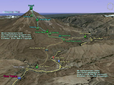
• Routes: There are four major Damavand trekking routes: the north route, the west front, the south route and the north-east side
Volcanic activity: It currently possesses thermal springs at the base and releases sulfuric gas from its summit.
• Peak location: Latitude and longitude coordinates, Lat: 35.954466°, Lon: 52.110020°.
• Nearest airports: IKA Airport and Mehrabad Airport.
• Last eruption: Around 5,300 BC was the last eruption.
• Symbolism: Damavand Mountain represents Iranian resistance to foreign occupation in Persian poetry and literature.
• Rank: The Damavand volcano is the third-highest of the volcanic seven summits (V7S). It is also the tallest mountain in Iran and the middle-east, the second-highest mountain in the northern hemisphere, and the tallest volcano in Asia. In terms of prominence, Damavand Mountain is the world's 12th-highest summit. 

Damavand Facts 23MDG0319A
03 September 2010

Damavand-Calories-Burned


Calories Burned
3 September 2010 Posted by MDG

Calories Burned & Fat Burning on Mt Damavand Iran
This is an example of fat burning and calories burned when ascending Mt Damavand Iran, it shows your energy expenditure during a 4 days expedition and gives you personal guidance how to exercise to reach your personal fitness for such a tough attempt to this giant volcano.

Today, heart rate monitoring, training and heart rate based exercise is being used by mountaineers, athletes, coaches, people trying to lose weight and personal trainers worldwide . This is a very useful way to optimise fat burning time while exercising, prevents over training and helps burn more fat calories, a suitable way for all abilities from novice to high performer.

The test is down from 25 to 28 August 2010, on a 29 years old male, a novice climber to Damavand Iran, 85 kgs, 187 cm, fat berning zone 135-151 beats/min, he is an EX smoker who has stopped smoking for 2 years. The equipment used for measurment in this test was a Polar Heart Rate Monitor wrist watch model F11.


Facts And Figuers Damavand Iran, By Mount Damavand Guide
Facts And Figuers Damavand Iran

Day1: Starting Day
From Camp2 Base 3050m to Camp3 4250m

Calories Burned= 4900
Fat Burning= 35%
Heart Beat Max= 181 BPM (Beats/min)
Heart Beat Avg= 153 BPM

Ascend and Activity Time = 5 h
Average climb speed = 950 m/h
Average Slop Angle = 21 Deg
Distance between camp2 and camp3 = 4700 m
Height from camp2 to camp3 = 1160 m

Day2: Acclimatization Day
From Camp3 4250m to near by heights about 4600m

Calories Burned= 2420
Fat Burning= 40%
Heart Beat Max= 177 BPM
Heart Beat Avg= 148 BPM

Ascend and Activity Time = 2.5 H
Average climb speed = ---
Average Slop Angle = 31 Deg
Distance camp3 to first ridge = ---
Height from camp3 = 400 m

Day3: Summit Day
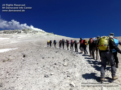
From Camp3, 4250m to the Summit 5671m and back to the Camp3

Calories Burned= 10700
Fat Burning= 45%
Heart Beat Max= 172 BPM
Heart Beat Avg= 146 BPM

Total Activity Time = 12 H
Ascend Time = 8 h
Descend Time = 4 H
Average climb speed = 400 m/h
Average Slop Angle = 31 Deg
Distance Camp3 to the Summit= 3300 m
Height from Camp3 to the Top = 1470 m

Day4: Return Day
Descend down From Camp3, 4250m to the Camp2 Base 3050m

Calories Burned= 2900
Fat Burning= 55%
Heart Beat Max= 145 BPM
Heart Beat Avg= 121 BPM

Descend and Activity Time = 4 H
Average Descend Speed = 1100 m/h
Average Slop Angle = 21 Deg
Distance Camp3 to Camp2= 4700 m
Height from camp2 to camp3 = 1160 m

damavand peak iran Photo by A. Soltani
Mt Damavand Summit 25 August 2010

More in MDG
Damavand iran tour september october november and december 2010, demavand iran, tourist attraction persia, expedition mountain tours iran, photo foto, pic picture damvand iran, weather forecast, hiking trekking tour damawand iran, damavandguide, demavand volcano, trek tour and ski resort information, trekking damavand mountain trekking tour, mountaineering foods, trekking google maps in iran, snowboarding and skiing competitions and training, abali hezar dasht, damawand bird watching, kooh saliman montian with picture, mountaineering mistakes, road and route map mount damavend, trekk from tochal to damavand in iran, weather conditions damawand, discover damawand through photos, damavandiran, damavandir, trip adviser, mountain persian trek, iranian mountain guides, iranmountainguides, mountainguide, peak picture, iran digital photo, photo damavand photos, picture pictures, climbing photo video, damavand mountain adventure foto, climbing photo, adventure holiday video, adventure tour image iran, travel and cultural photos persia jpg jpeg jpc.

Iran travel picture ico pic png raw, photo image picture damavand in bmp gif tif, map iran google satellite image, persian photography, digital photography, camera phones, camera, hobby photography persia, photo gallery digital camera, cameras, video gallery, persia cultural and outdoor activity tours, tourism & touring organization, climbing and mountaineering, hiking & trekking tour, tour 2010, foto gallery, photo center, video gallery, mountain picture 2010, beautiful mount iran, images of mountain, climbing and mountaineering pics, nature and ecosystem pics, picture hikking & trekking expedition, foto 2010 nature picture gallery persia, hiking and trekking 2010, pics 2010, mountain foto, best mountain photo, nice photos iran nature,tour news 2010, mountain desert and nature picture, climbing and trekking fotos, travel persia touring and tourism pics, photo climbing expedition alborz & zagros mountain ranges, landscapes of persia and outdoor recreation photo, ski mountaineering hiking and trekking images, images eco tour climbing pics.

Calories Burned MDG03SEP10A
Copyright © Mount Damavand Guide . All rights reserved.

07 March 2010

damavand-elevation


Elevation
Elevation of Mt Damavand Iran
Many sources indicate that the altitude of Mt Damavand is 5671m.
But the Wikipedia insists that the elevation of this volcano is only 5610m which I believe this is not correct. I had measured it before and I knew it was more that 5610m, but after reading this article, I made my new measurement on Friday 31 Aug 2007 at 11 AM.

Simultaneously, with two different brand of hand held GPS units, one Magellan GPS 315 and the other Garmin GPS Rino 120, by going to the top of all boulders and big rocks around the summit crater, I noticed all of them above 5610 M ! This is the result of my new measurement for the highest rock located on the south face which I beleive is summit of this mountain:

Summit Coordinate
Latitude 35-57-19 North
Longitude 52-06-37 East

Summit Altitude
By Magellan GPS 315 ---------- 5630 m - 18471 ft
By Garmin GPS Rino 120-------5645 m -18520 ft

If we assume the max tolerance of GPS units are +/-15M, in the worst case, the height is above 5610 M, ( ie 5630 - 15 = 5615 m ),
and for best and optimal the elevation is 5660 m -18569 ft or more,
( ie 5645 + 15 = 5660 m).

Although I believe the hand held GPS unit results may not be so accurate to refer to as a reliable reference, but I think it is more reliable that what is mentioned in Wikipedia! It worth to do some accurate measurements on the mountain with some modern and sophisticated equipments by some experts (and not newcomers)!


Mount Damavand Peak
Ardeshir Soltani on the highest point of Mt. Damavand 5671 meters
Photo by Ali Najafi

Read more, what NASA says about the elevation!

NASA1
In this topic NASA says the elevation is 5,670 meters (18,598 feet)
Mt. Damavand, Iran ...is an impressive stratovolcano that reaches 5,670 meters (18,598 feet) in elevation. Part of the Alborz Mountain Range that borders the Caspian Sea to the north, ...

NASA2
In this topic NASA indicates the elevation is 5681m (18,638 feet)
Iran: Elburz Mountains, Iran, and the more precipitous southern shore of the Caspian. Damavand volcano (5681 m) and ...

Mount Damavand Persia
Mount Damavand 5671 meters

More in MDG
Alborz mountains altitued and summits, articals mountains iran, mount adventure and climbing expedition, nature ecosystem mountains, nature and ecosystem gps track waypoint landmark, facts by gps, waypoint volcano, distance tehran to the mount, facts and figures, info route and trail map, google earth images south route, technical info, virtual trip and tour by google earth, informative guide book for height atitude and elevation, climbing and trekking tour mt damavand iran, distance tehran to south route, elburz mountains map, elevation by nasa, encyclopedia of iran mountains, equipment and gear, how long it takes to climb, how to climb, transport to and from the mountain how to get to volcano or to reach mount, technical info volcano, temperature and climate, wiki english, wikipedia english.

Elevation MDG7MAR10A
Copyright © Mount Damavand Guide . All rights reserved.

15 January 2010

damavand-difficulty


Difficulty
Mt Damavand Difficulty and Climbing Grade
The difficulty of this giant 5671m volcano is similar to Mt Kilimanjaro 5892 m in Tanzania and Mt Everest Base Camp 5380 m in the Himalayan Mountains.

This mountain is well-known for its moderate climbing slops, ascend to this summit is not technical, but physically a moderate challenge in summer and very difficult in winter, climbers should be fit enough to try it in any season, the main challenge of ascend are acclimatization, timing and the weather.
The attempts to this peak should be done only in a correct timing and in a good weather otherwise it could be very risky and tough in a bad weather and off-season.


Mt Damavand Route Difficulty and Climbing Grade
Mt Damavand South Route Difficulty and Climbing Grade
By Mount Damavand Guide

Climbing Grade In Summer
South Route
Route type: Fundamental-basic mountaineering
Difficulty: Moderate walk-up, easy descend

West Route
Route type: Basic-simple mountaineering
Difficulty: Moderate walk-up (basic snow and cold ), difficult descend

North East Route
Route type: Moderate mountaineering
Difficulty: long and hard ascend, cold and wind , long descend.

North Face Route
Route type: Moderate mountaineering, scramble, steep
Difficulty: The most difficult side, hard ascend, depending on season,
cold,windy, snow and Ice , difficult descend.

Some of climbers who ascend to the top from West, North East, or North Face prefer to descent from south route because of its easy descend footpaths !!


South Route Map Damavand
Damavand South Route Map
By Mount Damavand Guide

South Route Climbing Grade in Different Systems
Note: These grades are MDG opinion and regardless of the system used, they are approximation only, there are differences between grading in different climbing routes.

Difficulty: F, YDS class 2 (and sulphur gas above 5400 m)

UIAA: II
USA: 5.3
Australia: 11
France: 2

YDS Grade: Grade V, two day climb Classes 2 and 3
Adjectival grade: Moderate (M, or "Mod")
French Alpine: PD: peu difficile (not very difficult)
New Zealand: Grade 1, Easy scramble. Use of rope generally only for glacier travel.
Alaska Grade: Grade 2 Either a moderate fifth-class one-day climb, or a straightforward multiday nontechnical climb.
See also definition for Climbing Grade in Wikipedia.

Hiking & trekking Mt Damavand
Hiking & Trekking Mt Damavand Above Clouds
Photo by Ardeshir Soltani

More in MDG
Technical info for damavand, climbing grade and difficulty for differnt routes, trail map, google earth image, photo, pic, picture, video clip, gps landmark, facts and figures, equipment and gear,
tips and tricks, climbing and ski mountaineering tour, elevation, faq, hiking and trekking tour 2010, news 2010, summit photo, weather, ecosystem photo, picture and video, peak, damavand iran .

Difficulty MDG15JAN10D
Copyright © Mount Damavand Guide . All rights reserved.

13 April 2009

Facts


Facts
Mt Damavand Facts And Figuers
Some useful and interesting facts and figuers mainly focused on south route, base camp to the summit .

Abstract
Base camp to Summit

- Average ascend Time 10 hours
- Average climb speed 800 m/h
- Trail path distance 8000 meters
- Altitude gain base camp to summit 2630 m


Facts And Figuers about Mt Damavand, By Mount Damavand Guide
Facts And Figuers about Mt Damavand
By Mount Damavand Guide

Detail
Camp2 Base to Camp3 Bargah

- Average ascend time 4 h
- Average climb speed 1175 m/h
- Trail path distance between camp2 and camp3 4700 m
- Height from camp2 to camp3 1160 m

- Direct distance between camps 3182 m
- Avarage slope angle 21.8 deg
- Max slope angle 33.3 deg ( from 3807 m to 3861 m )
- Min slope angle 11.5 deg ( from 3095 m to 3115 m )

Camp3 Bargah to Summit
- Average ascend time 6 h
- Average climb speed 55o m/h
- Trail path distance between camp3 and summit 3300 m
- Height from camp3 to summit 1470 m

- Direct distance between camp3 and summit 2687 m
- Avarage slope angle 31 deg
- Max slope angle 39 deg ( from 4910 m t0 4973 m )
- Min slope angle 12.7 deg ( from 5522 m to 5544 m )

Over All Measurements
For Base camp to Summit
- Average ascend time 10 h
- Average climb speed 800 m/h
- Trail path distance between camp2 Base and summit 8000 meters

- Direct distance between camp2 Base and summit 5840 m
- Avarage slope angle 26.76 deg
- Max slope angle 39 deg ( from 4910 m t0 4973 m )
- Min slope angle 11.5 deg ( from 3095 m to 3115 m )

- Camp1 Polour Altitude 2270 m
- Camp1 Reineh Altitude 2070 m
- Camp2 Altitude 3040 m
- Camp3 Altitude 4200 m
- Mt Damavand Summit Altitude 5671 m

- Camp1 Polour to Camp2 Base distance 17.7 Km
( 11.3 Km asphalt road + 6.4 Km gravel road )
- Tehran ( Serah TehranPars ) to Camp1 Polour distance 73 Km
- Tehran IKA Airport to Camp1 Polour distance 133 Km

- Because of its accessibility by car, distance between camp1 and camp2 base is excluded in some measurements.
- Different equipments like hand held GPS, softwares and some available maps are used in these measurements and I hope it is accurate enough to some extent.

Quick Facts
Farsi Name:
Koh Damavand alternate Donbalvand , Dood koh ,Koh Damawand

English Name:
Mount Damavand or Volcano Damavand, Damavand Volcano
Alternate Spell:
Mount Damawand , Damawand , Demavand , Demavend....

Location and Coordinate
central Alborz range mountains Iran 80 Km North- East of Tehran

Altitude: 5,671 m - 18,605 ft see also GPS Landmark
Latitude: 35° 57' 19" N
Longitude: 52° 06' 36" E

Best place to get info : Mount Damavand Guide
Best Climbing Time: 10 June To 20 August
Best Climbing Side: South face

Best Climbing Program: 2 or 3 days
Best Start point: Polour, a small village at the south side of the Damavand
First Climbs : We believe there has been may unrecorded climbs in ancient years

First Recorded Climbed: 1837 by W.T Thomson
Status: not active also see: Volcanic Activity of Damavand
Most Recent Eruption: None on record
Nearest International Airport: MehrAbad or IKA Airport Teheran, Iran

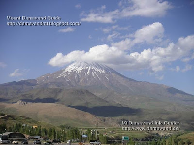
Damavand View From Polour Village
5671m
Damavand
Summit of Iran
Summit of Middle East
Highest Volcano in Asia and Europe
Second Highest Volcano in The North Hemisphere

More in MDG
Mt damavand difficulty, toughness, and climbing grade, wintwer ascend tour, summer hiking and trekking, tips and tricks, damavand tour 2010, photo and video, volcanic activity, weather, winter climb, world heritage, ski, skitour, news, faq, route map, volcano damavand.

Facts And Figuers MDG880125D
Copyright © Mount Damavand Guide . All rights reserved.