04 January 2010

Cave-Moon

Moon Caves
Caves of Iran
At southern slopes of Mt Damavand there are a series of natural and man made caves, these beautiful small caves are located mainly in Larijan district around Haraz Road near Abask and Moon villages in Mazandaran Province Iran. These series of natural prehistoric period caves were used by man and later they have been changed to a better haven later after tool invention, these natural/artificial caves have narrow entrances and could have been used as stronghold palce against any enemy in the ancient years.

Mt Damavand Poul e Moon Caves, Photo by A.Soltani
Mt Damavand Moon Caves

We have no idea of a reliable source of info for the mentioned caves and neither a reliable name, there might be evidence back to the stone age and there could be retrace of the steps of primitive men or an ancient tribe that lived once upon a time in the area, some locals believe that human skeletons belonging to cavemen have been found in these caves.

Mt Damavand Poul e Moon Caves, Photo by A.Soltani
Poul e Moon Caves near Mount Damavand

Poul e Moon Caves are the most important ones in the area, located at Poul e Moon junction ( GPS Landmark No 3 ) on Haraz Road to Reyneh Town, these small caves are located in a big wall and connected manualy by hand together through tunnels, you may climb to the lower ones easyl, but it is almost impossible to reach the upper ones wihtout the use of technical equipments and goog skill and high degree of rock climbing .
If you have an extra day for acclimatization in your itinerary before attempting Damavand mountain, it is recommended to visit this fascinating caves.

Alternate names and spellings
pol moon cave, pol e moun Cave, Kafar Koli Cave, dast kan cave, qar dast kan, ghar e dastkan
Note, dast kan mean hand made

Location and Coordinate
Pol e Moon junction
Altitude: 1683 m
Latitude: 35-53-25 N
Longitude: 52-11-53 E

Other Major Caves in Iran
Ali Sadre Cave Hamedan Iran, water cave
Karafto Cave Kordestan Iran,
Katalekhor Cave Zanjan,
Quri Qaleh Cave Kermanshah
Sahoolan Cave Mahabad, pigeon cave, water cave
Shapour Cave Kazeroon, statue king shapour the great cave
Vara Cave Jahrom

Road Map Tehran To Mt Damavand
Road Map Tehran To Mount Damavand


Photo Gallery Poul e Moon Caves Mt Damavand

More in MDG
Cave civilization damavand, cave formation, water caves in iran, caves Iran, cave carving, cave tour, tour damavand, cave alisadr hamedan iran, cave katalekhor zanjan, cave karafto kordestan, cave pol e moon larijan, cave quriqaleh kermanshah iran, cave sahoolan mahabad iran, cave shapour kazeroon, cave vara jahrom fars, tour 2010 mt damavand iran, cave tour iran 2010, photo caves iran.

Moon Cave MDG4JAN10A
Copyright © Mount Damavand Guide . All rights reserved.

Labels:

03 January 2010

New Hut


Camp 3 New Hut
Mt Damavand South Route Campsites
Bargah Sevom New Hut is located on the south trekking route, very closed to the Camp 3 Bargah old shelter/refuge, the construction of this new mountain resort was finished in 2009, although it is not quite complete yet, but you may reseve in advance and get the benefit of its very comfortable private rooms. This mount hut is made by Iran Mount Climbing Federation.

At altitude of 4250 meters above sea level, it is one of the highest in the word and the best place for acclimatization and accommodation in the area, it has private and shared rooms with bunk beds and a very safe haven in case of emergency and any bad weather, it is scheduled to be open through the entire year even in winter, but if you intend to use this hut, it is suggested to get the latest news and by booking in advance, make sure of your room before your travel to the area.

Mt Damavand Camp3 New Hut

Facilities and Advantages
- In case of emergency and any bad weather it is a very safe haven
- Best recommended for acclimatization and accommodation.
- 4 private rooms with bunk beds.
- A big shared saloon with bunk beds.
- Cooking equipments and kitchen.
- Mobile network avalable in some area.
- Solar electricity power and few hours light at night.
- some drink and water avalable in summer.
- Very good management.

Disadvantages
Very handsome campsite and it is an ideal place for mountain climbers despite some minor disadvantages.
- You should book a place in advance because it is crowded in summer.
- Food not avalable yet.
- No telepnone line, no permanent electricity yet.
- It is quite cold especially at night, no central heating.
- No cold & hot water taps.
- Outside toilet.

Quick Facts
Altitude 4250 m

Coordinate
Latitude 35-55-57 N
Longitude 52-06-32 E

Location
Distance from Base Camp 4 to 6 hours
Ascent to summit 5 to7 hours
Descent from summit 2 to 4 hours

Note:
- Remember that there is in no hut in other routes of Mt Damavand and you have to use shelter/refuge or tent in other sides only.
- bunk beds = two beds, one above the other, 2 stage beds

Accommodation in Mt Damavand south route Camp3 New Hut
Accommodation in NewHut Damavand
Photo by Ali Najafi

Mt. Damavand New Hut Bed Rooms
Mt Damavand Hut
Remember this hut is under construction yet
and beds should look like this in near future!


South Route Map Mt Damavand
Damavand South Route Map

More in MDG
Mt Damavand acclimatization and accommodation, polour and bargah sevom campsites, iran mount federation camp, panagah, lodge, resort, hotel, hostel, suite, first camp , second camp, mid camp, third camp, goosfand sara base shelter and mosque, info damavand mount, tourism and travel to iran.

Camp 3 New Hut MDG3JAN10D
Copyright © Mount Damavand Guide . All rights reserved.

Labels:

Bargah


Camp 3 Bargah
Mt Damavand South Route Campsites
Bargah Sevom shelter is an old refuge located at altitude 4220 m, this small camp was the main safe haven and mountain resort on the south face for many years before the New Hut was made in 2009 in this area. This shelter is a good resting place for off season, but it is not suitable in summer because it is too crowded and dirty.

Bargah Sevom shelter/refuge is losing its popularity and usage to the new hut. In this campsite you can find some food, water, rent tent and sleeping bag in summer, but it is a good idea to bring your own stuff.

For more comfort and privacy in summer it is highly recommended to bring and use your private tent, or use the benefit of the new hut which has started to give services to climbers since 2009, you may book and use its very comfortable private rooms.

Mt Damavand Camp3 Bargah Sevom Shelter
Damavand Camp3 Bargah Sevom Shelter (yellow)

Facilities and Advantages
- In a bad weatherit is a safe haven.
- For off-season it is a good place for acclimatization and accommodation .
- This refuge has some bunk beds.
- Running water is avalable in summer.
- Mobile network avalable.
- In summer some food, drink and water avalable.
- outside toilet.

Disadvantages
- Small old shelter with no facilities.
- Noisy, very crowded and too dirty in summer.
- Not a suitable plcae for acclimatization in summer.

Quick Facts
Altitude 4220 m

Coordinate
Latitude 35-55-54 N
Longitude 52-06-30 E

Location
Distance from Base Camp 4 to 6 hours
Ascent to summit 5-7 hours
Descent from summit 2- 4 hours
See also Damavand GPS Landmark.

Impotant Note
This is the last campsite of the south route, and there is no more hut or shelter above Bargah Sevom refuge and the new hut.

Mt. Damavand Camp3 Bargah Sevom Shelter/Refuge
Mt Damavand Camp3 Bargah Sevom Old Refuge


South Route Map Mt Damavand
Mt Damavand South Route Map


Damavand Camp 3 Bargah Sevom Camp 4220 m

More in MDG
All mt damavand camps, iran mountain camps, iran mout federation camps and huts, base camp refuge, base camp shelter, mosque, goosfand sara, camp 3 hut, mount resort, panagah simorgh shelter, panagah takht feridon, hiking & trekking tour 2010 iran, tour damavand iran, gps landmark, route map, photo, picture and video, news, google earth image, hostel, hotel tehran, suite iran, weather and climate damavand دماوند ایران.

Camp 3 Bargah Sevom Shelter MDG3JAN10C
Copyright © Mount Damavand Guide . All rights reserved.

Labels:

Base


Camp 2 Base
Mt Damavand South Route Campsites
Base camp is a mountain camping site located at altitude 3040 m above sea level and is the starting point for summer trekking to Mt Damavand. In this area you may find a small mountain shelter or refuge, a mosque called Saheb Zaman (or Saheb al Zaman) and a sheepfold.

In summer and climbing season, strong cars like 4WD Jeeps and land rovers transfer climbers and their equipment to this campsite, it is possible to find some water, food and drink, but it is recommend to bring and use your own staff and also you may find mule and porter to carry your equipment to the last camp.

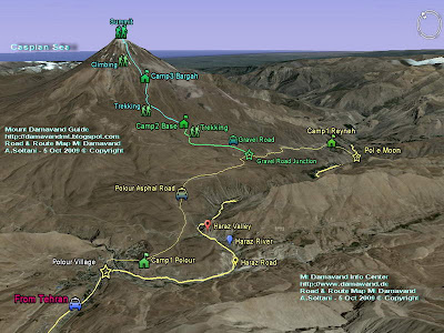
Remeber in other seasons, this area is almost remote and restricted and due to heavy snowfall the gravel road is blocked and cars may not be able to reach this place, the starting point in winter is gravel road junction (GPS Landmark No5) or somewhere closed to that point.

This place is not recommended for any accommodation and acclimatization in summer and crowded climbing season, but if you insist to use this place, you may bring your own tent and use it few hundred meters away from the area, in other seasons when it is not too crowded you can use the shelter/refuge or the mosque with no problem.


Base Camp Mount Damavand
Mt Damavand Base Camp or Goosfand Sara 3040 m

Facilities and Advantages (mostly in summer season)
- South route starting point.
- Transfer by car to this place.
- Mobile network available.
- Mule and porter available.
- Some food, drink, water.

Disadvantages (mostly in summer)
- Worst campsite it area, it need some major reconstruction.
- An old shelter/refuge with no facilities.
- Not a suitable place for acclimatization and accommodation.
- There is no running water most time.
- Noisy and crowded and too dirty.
- Not a suitable place for foreigners traveling to this mountain.
- In fact it is invaded by people, cars....
- No proper toilet.
- No management at all.

Note Remember for acclimatization, it is recommended to use Camp 1 Polour or Camp 3 New Hut.
See also Warning.

Altitude 3040 m

Coordinate
Latitude 35-54-10 N
Longitude 52-06-34 E

Other Spelling and Names
English name, Base Camp, Mosque, Base shelter/refuge, sheepfold.

Farsi Name, Goosfand Sara ye Ehsan, Masjed Saheb al Zaman,

Old name: Alaf Chin
Gosfand Sara means sheepfold.

South Route Map Mt. Damavand
Mount Damavand South Route Map


Road Map Tehran To Mt Damavand
Road Map Tehran To Damavand


Mt Damavand Camp 2 Base 3040m

More in MDG
All iran mount federation camps and resorts, base shelter, bargah sevom refuge, saheb al zaman mosque, camp 3 new hut, simorgh shelter, panagah takht feridon refuge, route map, summer itinerary, photo, picture and video clips, mountain guide, guided, iran nature and ecosystem guide, ski tour, ski mountaineering tour 2010, mt. damavand, winter climb and ski in 2010, volcano damavand, damawand, demavand, damavan, climate and weather damavand iran دماوند ایران.

Camp 2 Base MDG3JAN10B
Copyright © Mount Damavand Guide . All rights reserved.

Labels:

Reyneh


Camp 1 Reyneh
Mt Damavand South Route Campsites
Reineh hut is the oldest Mt Damavand campsite, it was build in 1939 and reconstructed in 1969, since then there has been no major changes in this building, this small old camp is located in Reyneh Town and it was the only main mountain resort in the area for many years before the construction of Camp 1 Polour in Polour Village in 2004. In recent years among Iranian climbers and foreign tourists, Reineh hut has lost its popularity to the new hut.

If you want to go to Damavand from north of Iran, either from Mazandaran or Gilan or province, you may use the Reineh as your starting point to the south route, but if you travel through capital Tehran, you have a better option and you are recommended to use Polour Hut which is much better place and a shortcut to the Base Camp.


Camp 1 Reineh Mount Damavand
Mt Damavand Camp 1 Reineh

Advantages- Access way to the south face from north of Iran, ie Mazandaran and Gilan province.
- Old and ordinary camp for accommodation and acclimatization.
- Shared rooms with bunk beds and private suite.
- Cooking equipment and kitchen.
- Central heating.
- Telephone line and electricity.
- Water taps, cold & hot, shower and toilet.
- 2 Mobile networks available in the area.

Disadvantages- Longer access from Tehran compared to Polour Hut.
- A small hut with little facilities compared to Polour New Hut.
- This old camp need some reconstruction.
- Needs better management.

Important Note
Please note, it is not recommended to use any unidentified place  as your accommodation either in the towns or villages near the mountain. The safest and the best resting place are Iran Mountain Federation Camps ONLY.

Coordinate
Altitude: 2078 meters
Latitude: 35-52-58 N
Longitude: 52-09-58 E

Reineh Town
Rineh is a beautiful small town located in south slopes and at foot of Mt Damavand in Mazandaran province, Iran. It is the capital of the Larijan district of Amol County.

Alternate Names and spellings
Reineh City, Reyneh Town, Rayneh, Reneh, Rehneh.
In Persian رینه، شهر رینه ( pronounced ray ne)


South Route Map Damavand mount
Damavand South Route Map


Mt Damavand Camp 1 Reyneh

More in MDG
Mount federation campsites iran, base shelter, panagah, refuge, resort, shelter, hostel, hotel, suite, camp 1 polour, camp 2 base shelter, mosque, goosfand sara, camp 3 bargah sevom, camp 3 new hut, first camp, second camp, mid camp, last camp, simorgh shelter, takht feridon shelter, ski mountaineering tour 2010 mt damavand iran, tehran to damavand, gps track, gps waypoint landmark, route and trail map, photo, picture and video, news 2010 iran, google earth, winter climate, hike, trek, climb, damavand iran دماوند ایران.

Camp 1 Reyneh Hut MDG3JAN10A
Copyright © Mount Damavand Guide . All rights reserved.

Labels:

02 January 2010

Polour


Camp 1 Polour Hut

Mt Damavand South Route Campsites
Polour Hut or Lodge is a comfortable hostel and a cosey place for acclimatization and accommodation in the area, it has some shared bed rooms with bunk beds and 2 private suite, it is scheduled to be open through the year, but it is highly recommended to reserve and book your place in advance in the summer season and crowded holidays.

This new complex sport center is the best starting point for climbing Mt Damavand either from calsic south route or the west route, it was established in 2004 by Iran Mount Climbing Federation, it is located in Polour Village closed to Haraz Road in Larijan district of Mazandaran Province Iran.

Mount Damavand Camp 1 Polour
Mt Damavand Camp 1 Polour Altitude 2270 m

Advantages
- A shortcut to Base Camp.
- Suggested starting point for south and west routes.
- Best place in the area for acclimatization and accommodation.
- Private suites and shared rooms with bunk beds .
- Cooking equipments and kitchen.
- Tap water, telephone line and permanent electricity.
- Good toilet and showers, cold & hot water taps.
- 2 mobile network avalable in the area.
- Central heating, it is quite warm and comfortable in cold weather .
- Water, some food and soft drink and mountain gear avalable.
- Good management.

Disadvantages
There is no major disadvantages for this beautiful mount resort, but it is gaining popularity which could make it crowded in the peak of climbing season and you should book your room in advance.

Quick Facts
Altitude 2270 m
Coordinate
Latitude 35-50-50 N
Longitude 52-03-36 E

Note
Haraz Road is one of the main roads which passes through Alborz Mountains and connects capital Tehran to north of Iran and the Caspian Sea in Mazandaran province, this road passes by Mt.Damavand through beautiful Haraz Valley closed to Haraz River.

Other Names and Spellings
Panagah polor, Polur resort, poolor hostel, poolour lodge.

South Route Map Damavand
Mount Damavand South Route Map


Road Map Tehran To Damavand
Road Map Tehran To Mt Damavand


Damavand Camp1 Polour Hut Altitude 2270 m

More in MDG
Iran mountain federation campsites, refuge, resort, shelter, hostel, hotel, suite, village, north east tahkt feridon shelter, west simorgh shelter, reyneh, base camp, bargah sevom camp, bargah sevom new hut, hiking & trekking ecosystem and iran nature tour 2010, gps landmark, route and trail map, itinerary 2010 damavand mt iran, guided tour, ski and climbing tour iran, winter climb and ski mountaineering, news 2010 iran, google earth sat image, south, east, west, winter climate and weather damavand iran دماوند ایران.

Camp 1 Polour Hut MDG2JAN10B
Copyright © Mount Damavand Guide . All rights reserved.

Labels:

Alborz


Alborz

Alborz Mountain Range is located in northern Iran and is extending from west to east of the country, it is a natural barrier between the Caspian Sea and the central plateau of Iran.
Many peaks are given the name Alborz, such as Mount Elbrus in the Caucasus Mountains, and Mount Elbariz (Albariz) in the Kerman, also there is a peak in the Hindu Kush, near Balkh, called Mount Elburz, these names come from Alborz mountains in Iran. This range is made of sedimentary series, it has a forests ecoregion on the northern slopes in the Caspian Sea zone.
The artificial images in this article are made by Views of the Earth by using computer rendering techniques.

Alborz Mountains, Caspian Sea and Damavand
Mount Damavand in the Alborz Mountains
See full size image by Views of the Earth

Due to the heavy snowfall in winters there are many ski resorts in Alborz, which some are among the best in the word for either on-piste or off-piste and wild ski mountaineering.

Major Ski Resorts in Alborz Mountains Iran
AbAli ski resort, piste, Haraz Road, Tehran
Darbandsar ski resort, piste, Karaj,Tehran
Dizin, grass ski piste,, Karaj,Tehran
Dizin ski resort, piste,, Karaj,Tehran
Lasem, off piste ski area
Mt Damavand, off piste ski zone, Mazandaran Province, Iran
Shahmirzad, Semnan Province
Shemshak ski resort, piste, Karaj,Tehran
Tochal ski resort, piste,Tehran Iran

Quick Facts
Lenght: about 1500 km long
Width: varies betwee 30 to 130 km
Highest Peak: Mount Damavand 5671 meters
Avarage height: about 3000 meters
With many peaks above 4000 meters

Famous peaks in Alborz Mountain Range
Central Alborz Range
Mt Damavand 5671m
Mt Azad Koh 4395m
Mt Kholenow 4375m
Mt Nazer (Leghas) Bozorg 4350m
Mt Palan Gardan (Paloon Gardan) 4250m
Mt Koloon Bastak 4200m
Mt Sarakchal 4150m
Mt Vorvasht 4100m
Mt Kharsang 4100m
Mt Tochal 3960m
Mt Mehrchal 3920m
Mt Atash Kouh 3850m
Mt Shahneshin 3850m

West Alborz Range
Mt Sialan 4250m
Mt Shah Alborz 4200m
Mt Khash e chal 4180m
Mt Kehar 4040m

Takht e Soliman (Soleyman) Range
Mt Alam 4850m
Mt Khersan Shomali (North Khersan) 4680m
Mt Khersan Jonobi (South Khersan) 4660m
Mt Takht e Soliman (Soleyman) 4660m
Mt Siasang 4610m
Mt Haft Khan 4540m
Mt Chaloon 4515m
Mt Siagook Jonobi (South Siagook) 4500m
Mt Siagook Shomali (North Siagook) 4445m
Mt Siakaman 4470m
Mt Shaneh Kouh 4465m
Mt Kolahoo 4410m
Mt Gardoon Kouh 4400m
Mt Mian Sechal 4350m
Mt Lashkarak 4255m
Mt Zarin Kouh 4200m
Mt Alanehsar 4050m
Mt Karma kouh 4020m
Mt Pasand Koh 4000m
Mt Sializ 3975m

Other Names and Spellings
Alborz in Farsi البرز, رشته کوه البرز , Alburz, Elburz and Elboroz.

Alborz Mountains, Caspian Sea and Mt Damavand
Alborz Mountain Range, Caspian Sea and Mt Damavand
Fantastic work by Views of the Earth
See full size image by Views of the Earth

More in MDG
Volcano damavand iran, route map iran, eco, adventure, nomadic and outdoor activity tours 2010 iran, hiking & trekking, bird watching and camel riding tour iran, zagros, dena, sabalan, alam Kouh climbing tour, iran desert safari, iran ski mountaineering tour 2010, iran tour operator, touring and tourism, persian cultural tours, travel to persia, damavand iran 2010.

Alborz MDG2JAN10A
Copyright © Mount Damavand Guide . All rights reserved.

Labels: