Showing posts with label Home. Show all posts

25 May 2012

Parvaneh-Kazemi-Lhotse

Mt Lhotse News 2012

Parvaneh Kazemi Conquered Mt Lhotse
Parvaneh Kazemi Conquered Mount Lhotse 8,516 m immediately after her successful climb to Mt Everest, the Himalayan summit. Mount Lhotse is Parvaneh`s third 8000 m successful ascend.

Mrs. Kazemi stood on Mt Lhotse peak on 25 May 2012 at 7:30 local time, along with  sherpa Nima Gyalzen from Bedin, only 7 days and 18 hours after summiting Everest.

Parvaneh Kazemy is the first Persian lady Hymalia mountaineer to manage two summit over 8000 meters is a single climbing season and just in one week!

Mount Lhotse 8,516 metres (27,940 ft) is the 4th highest peak on Earth (after Everest, K2 and Kangchenjunga).

Congratulation and best wishes to Parvaneh on her return.
Moun Damavand Guide Team 25 May 2012.

Parvaneh Kazemi
Parvaneh Kazemi

پروانه کاظمی بر فراز قله لوتسه چهارمین قله بلند جهان
پروانه کاظمی هیمالیا نورد زن ایرانی موفق شد بامداد جمعه 5 خرداد 1391ساعت 7:30 بامداد بوقت محلی قله لوتسه چهارمین قله بلند جهان به ارتفاع 8516 متر را صعود کند و این در ست یک هفته  بعد از فتح قله اورست است. این برای اولین بار استکه یک کوه نورد زن ایرانی موفق میشود دو قله بالای 8000 متری را در یک فصل صعود و انهم در عرض یک هفته  و 18 ساعت صعود نماید

با عرض تبریک به این بانوی هیمالیا نورد و افتخار آفرین ایرانی

The South Face of Lhotse as seen from the climb up to Chukhung Ri.
The South Face of Lhotse as seen from the climb up to Chukhung

Mount Lhotse 8,516 metres (27,940 ft)
Lhotse is the fourth highest mountain on Earth (after Mount Everest, K2 and Kangchenjunga) and is connected to Everest via the South Col. In addition to the main summit at 8,516 metres (27,940 ft) above sea level, Lhotse Middle (East) is 8,414 metres (27,605 ft) and Lhotse Shar is 8,383 metres (27,503 ft). It is located at the border between Tibet (China) and the Khumbu region of Nepal.

Lhotse is best known for its proximity to Mount Everest and the fact that climbers ascending the standard route on that peak spend some time on its northwest face; see below. In fact Lhotse has the smallest topographic prominence value of any official eight- thousander, as it rises only 610 m (2,000 ft) above the South Col. Hence it is often seen as a minor eight-thousander.

However, Lhotse is a dramatic peak in its own right, due to its tremendous south face. This rises 3.2 km (2.0 mi) in only 2.25 km (1.4 mi) of horizontal distance, making it the steepest face of this size in the world. The south face has been the scene of many failed attempts, some notable fatalities, and very few ascents.

Mt Damavand Iran
Mt Damavand Iran

More in MDG
Damavand hiking trekking and climbing tour. Guided mountain tour Iran. Climbing expedition tour Alborz and Zagros Mountains. Ski touring and snowboard tour to Iran ski resorts. Mt Damawand mountaineering and climbing tour 2012. Iran climbing travel agent and agency. Iran mountain tourism trip advisor. Transport from IKA International Airport in Tehran to Iran ski resort.

Parvane Kazemi Lhotse MDG12JUN12
Copyright © Mount Damavand Guide. All rights reserved.

19 May 2012

Parvaneh-Kazemi-Everest

Mt Everest News 2012

Parvaneh Kazemi Conquered Mt Everest
Mrs. Parvaneh Kazemi after 45 days attempt managed to stand on the Himalayan summit, Mt Everest Peak 8,848 meters (29,029 feet) on 18th May 2012 at 13:30 local time. This Iranian lady is the first climber in the world to summit Mount Everest in 2012 climbing season along with her favorite climbing sherpa, Nima Gyalzen from Bedin.

Congratulation and best wishes to this great Persian female Hymalia Mountaineer.
Mount Damavand Guide Team. 19 May 2012

Parvaneh-Kazemi
Parvaneh Kazemi

About  Parvaneh Kazemy
Born: Sep 1970 Tehran, Iran.
Academic Degree: University Dgree in Mathematics.
Occupation: Mathematics Teacher.
Hobby: Mountaineering, mountain guide, photography.
Club: Member of Espilat Mountaineering Club Tehran, Iran.

Mountaineering Ranks and Records
Facts and Figures about Parvaneh
- First NGO Iranian lady to attempt Mt Everest independently.
- Third Persian female climber to ascend Mt Everest summit.
- First mountaineer to stand on Mt Everest Peak in 2012.
- First Iranian lady to summit Mt Manaslu, Mt Muztagata and Mt Ama Dablam.

Mountaineering Experience and Backgrounds
- Over 8000 m: Mt Manaslu (8163m) 29 April 2011 and Mt Everest (8848m) 19 May 2012.
Immediately after her successful climb to Everest, in May 2012, Parvaneh is attempting her third climb to 8000 meters, Mt Lhotse 8,516 metres (27,940 ft) the fourth highest mountain on Earth (after Mount Everest, K2 and Kangchenjunga).
- Over 7000 m: Mt Muztagh Ata, or Muztagata 7,546 m (24,757 ft) in 2010
- Over 6000 m: Mt Ama Dablam 6,812 metres (22,349 ft), in 2011

10 years mountain climbing over 4000 and 5000 meters.
- Over 5000 m: Mt Damavand 5671 m (many times).
- Over 4000 m: Mt Alam Kouh 4850 m, Mt Sabalan 4820 m, Mt Dena 4350 m, Iran.
- Over 3000 m: Mt Tochal 3960 m (almost every week!)

Parvaneh-Kazemi
Parvaneh Kazemi


پروانه دخت ایران زمین بربام گیتی ایستاد
پروانه کاظمی کوهنورد سخت کوش ایرانی در بک تلاش 45 روزه موفق به فتح قله اورست در روز جمعه ۲۹ اردیبهشت ۱۳۹۱ ساعت ۱۳:۳۰ به وقت محلی شد. پروانه سومین بانوی هیمالیا نورد ایرانی استکه موفق به این افتخار آفرینی شده. اورست با ارتفاع 8848 متر بلند تری کوه جهان است. پروانه نخستین کوهنورد جهان استکه باتفاق شرپا نیما گیالزن در سال ۲۰۱۲ میلادی بر بام جهان دست یافته

شایان ذکر است، پروانه اولین بانوی کشور استکه به صورت انفرادی و مستقل وبدون استفاده از امکانات و حمایت فدراسیون کوهنوردی ایران و تنها با هزینه شخصی خود این صعود را انجام داده است

درود بر پروانه بانوی هیمالیا نورد ایرانی
از طرف دوستان و همنوردان او

Parvaneh-Kazemi
Parvaneh Kazemi

Mount Everest 8,848 metres (29,029 ft)
Everest is the earth's highest mountain. The Tibetan name is Chomolungma or Qomolangma which means "Holy Mother". It is located in the Mahalangur section of the Himalayas. The international border between China and Nepal runs across the precise summit point. Its massif includes neighboring peaks Lhotse, 8,516 m (27,940 ft); Nuptse, 7,855 m (25,771 ft); and Changtse, 7,580 m (24,870 ft).

The highest mountain on the earth attracts many well-experienced mountaineers as well as capable climbers willing to hire professional guides. While not posing substantial technical climbing challenges on the standard route, Everest presents dangers such as altitude sickness, weather and wind.

Mount Everest Map
Mount Everest Map

Everest from Kala Patthar in Nepal
Manaslu was first climbed on May 9, 1956 by Toshio Imanishi and Gyalzen Norbu, members of a Japanese expedition. It is said that "just as the British consider Everest their mountain, Manaslu has always been a Japanese mountain".

Manaslu at 8,156 metres (26,759 ft) above mean sea level (m.s.l) is the highest peak in the Lamjung District and is located about forty miles east of Annapurna. The mountain's long ridges and valley glaciers offer feasible approaches from all directions, and culminate in a peak that towers steeply above its surrounding landscape, and is a dominant feature when viewed from afar.

The Manaslu region offers a variety of trekking options. The popular Manaslu trekking route of 177 kilometres (110 mi), skirts the Manaslu massif over the pass down to Annapurna. The Nepalese Government only permitted trekking of this circuit in 1991. The trekking trail follows an ancient salt-trading route along the Budhi Gandaki river. Enroute, 10 peaks over 6,500 metres (21,300 ft) are visible, including a few over 7,000 metres (23,000 ft). The highest point reached along the trek route is the Larkya La at an elevation of 5,235 metres (17,175 ft). As of May 2008, the mountain has been climbed 297 times with 53 fatalities.

Manaslu Conservation Area has been established with the primary objective of achieving conservation and sustainable management of the delimited area, which includes Manaslu.

Mount Manaslu at sunrise

Mount Muztagh Ata  7,546 m (24,757 ft)
Muztagh Ata, or Muztagata ("ice-mountain-father"), is the second highest (7546 metres) of the mountains which form the northern edge of the Tibetan Plateau (not the second highest of the mountains of the Tibetan Plateau). It is sometimes regarded as being part of the Kunlun Shan, although physically it is more closely connected to the Pamirs. It is also reputedly one of the easiest 7,000 m peaks in the world to climb, due to its gentle western slope and the comparatively drier weather of Xinjiang.

Muztagh Ata lies just south of Kongur Tagh, the highest peak of the Kunlun Shan. Together they form a somewhat isolated group, separated from the main chain of the Kunlun, and also separate from the Pamir Mountains to the west. (Both peaks are sometimes regarded as being in the "Chinese Pamir", and are more closely connected to the main Pamir group than the main Kunlun group.) Not far to the north and east of this group are the lowlands of the Tarim Basin and the Taklamakan Desert. The Karakoram Highway passes very close to both peaks as well as Karakul Lake, from which the mountain is conveniently viewed. The closest city is to the mountain is Tashkurgan, the westernmost town in China and very close to the border with Pakistan.

Muztagh Ata, as viewed from the Karakoram Highway

Mount Ama Dablam 6,812 m (22,349 ft)
Ama Dablam is a mountain in the Himalaya range of eastern Nepal. The main peak is 6,812 metres (22,349 ft), the lower western peak is 5,563 metres (18,251 ft). Ama Dablam means "Mother's necklace"; the long ridges on each side like the arms of a mother (ama) protecting her child, and the hanging glacier thought of as the dablam, the traditional double-pendant containing pictures of the gods, worn by Sherpa women. For several days, Ama Dablam dominates the eastern sky for anyone trekking to Mount Everest basecamp.

Ama Dablam is the third most popular Himalayan peak for permitted expeditions. The most popular route by far is the Southwest Ridge (right skyline in the photo). Climbers typically set up three camps along the ridge with camp 3 just below and to the right of the hanging glacier, the Dablam. Any ice that calves off the glacier typically goes left, away from the camp. However, a 2006 avalanche proved otherwise. A climbing permit and a liaison officer are required when attempting Ama Dablam. As with Mt. Everest, the best climbing months are April–May (before the monsoon) and September–October.

Mount Ama Dablam, The classic view from the southwest

Parvane Kazemi Everest MDG23MAY12B
Copyright © Mount Damavand Guide. All rights reserved.

01 February 2011

About-Us


About Us
1 Feb 2011, Updated by Sherppa.

Safety is our first priority and main concern.
We have been climbing about 30 years and over 20 years our main focus has been Mt Damavand guiding. It would be no exaggeration to say that this experience has led MDG to become the primary choice for Damavand climbing, mountaineering and hiking trekking.

Mount Damavand Guide is an energetic NGO group of Iranian mountain guides that has been formed by mountaineers who were among the pioneers of organising climbing and trekking expeditions for foreign climbers and incoming tours. MDG was founded in 1990 as a nationally based mountaineering club by members of the Azad Moutaineering Group of Iran.

We have a team of highly trained and qualified guides, which are guarantee of safety and quality days on the mountains. Our guides are senior mountain guides and the most experienced in the country, members of 100 Damavand Club, and Iran Mountain Federation.

We are based in Tehran and operate all season in the Alborz and Zagros Mountain Ranges. Each year we take many foreign groups and individual climbers to Damavand summit and share our experience to give them the best chance of success.

We offer quality tours covering a variety of outdoor activities, from complete beginner summer hiking, ideal for newcomers, up to most advanced winter climbing and alpine style experiences.

Think Less Climb More!
We are a friendly team who prefer to be on mountains and in campsite instead of sitting in a physical office.
With 24 consecutive climbs to Mt Damavand summit in 2007, we have the first rank of ascends for a single year to this mountain.


Mt Damavand climbing tour, Photo by Sherpa
Hiking & trekking Tour above clouds, Mt. Damavand Iran.
Photo by Ardeshir Soltani

MDG Main Goals
Our Mission:

Our aim is to offer a friendly, professional and especially secure service to our clients for a correct price. We offer well cared full services to agencies, private groups of any size and individuals who travel independently and wish to go expedition by themselves with personalised service as well as private logistics for groups. Our strength is experience in handling international clients.

Safety
Safety is our first priority.
MDG is determine to provide the safest mountain experience possible, aside from providing an excellent service we know that our clients will be in very safe hands. MDG guides with the best mountain knowledge, experience and training to increase your chance of reaching the summit while maintaining the necessary safety margins.

MDG 's Goals
Assist our clients to reach the summit.
Respect our unique natur environment.
Teach through the mountain adventures.
Present the best and enjoyable mountain experience possible.

Summit
Our main goals is to see our clients reach the summit.
Climbing needs a considerable amount of time, money and energy on an attempt, and the greatest chance of safely reaching the summit is based on the our high quality guides who are the core of tours.

Education
Our guides pass on knowledge that has been gained through numerous years of guiding on mountains.
Our guides are excellent teachers and safety skills necessary for successful and enjoyable climbs.

Damavand base camp! Photo by Ardeshir
Mt. Damavand Base Camp
Photo by A. Soltani

Services
Itinerary

Use one of our recommended programs or set up your own itinerary.
All the itineraries are designed according to clients' choice and services are arranged according to your budget.

Guide
Visit also Guide
Our guides have a background of many years experience working with trekking and climbing groups,
and have genuine interest and enjoyment in providing quality service with a helpful & friendly attitude.
They contribute their experience to ensur that our clients have a wonderful holiday on Iranian mountains.
- Mountain guides.
- Experienced and qualified climbing & trekking guides.
- English speaking guides.
- City and caltural trained & professional staff.

Services
Visit also Services
- We offer tour leader discounts.
- Day tours.
- Personal help & advice.
- Quality friendly personal service.
- Licensed guides.
- Hire of mules and muleteers.
- Campsite guards.
- Porters.

Equipment
- Free safety, equipment and logistics information.
- High standard tents and equipment in good condition.

Food
- Food and cooks.
- Delicious and nutritious trek meals.
- Vegetarian & special diets are available for people who do not eat meat.

Reservations
- Reservation of your hotel or hostel.
- Private Bus, Flight & Tourist Bus Reservations.

Tour
Visit also Tours
We organize regular private tailor made and shared tours.
- Mount Damavand tours.
- Climbing and mountaineering, in Alborz and Zagros mountains.
- Hiking & trekking, natural Iran beauties and lanscapes.
- Camping and mountain holidays.
- Cultural & sightseeing tours.
- Day and city tours.
- Ecosystem, fauna and flora, natural attractions
- Nature and adventure.
- Outdoor tourism activity andr Recreation.
- Rock and ice climbing.
- Ski Mountaineering, off piste skiing.
- Snowboard, ski touring.
- Winter climbing, Mt Damavand.

Transport
- Meet at airports and private airport/hotel/bus station transfers.
- Transfer to and from the airport to the hotel.
- Private transport Tehran – Damavand– Tehran.
- Private Trek & Tour Transport in well maintained vehicles.

Other Activities
- Winter hill walking and scrambling.
- Rock climbing in summer.
- Snow and ice climbing if winter conditions permit.
- Downhill skiing.
- Ski mountaineering.
- Mountain biking.
- Caving.

Our Websites
Our websites are the only truly 'comprehensive' online guide to Damavand mountaineering, skitouring, snowboarding, ski expeditions in Iran, with practical info on internet making MDG a popular name in adventure and outdoor services.
Our weblog Mount Damavand Guide gives up-to-date news and info on Mount Damavand
Our website Mt Damavand Info Center is the best source of info for Damavand climbing tours.

Contact Details
For our helpful advice please get in touch:
Mount Damavand Guide
Email: Sherppa[at]gmail.com
P.O.Box 16765-1486, Tehran Iran.


Mount Damavand Photo Gallery

More in MDG
Damavand Ski and snowboard, damavand tour 2011, mountaineering and climbing tour organizer iran, guided tour, mountain guide iran, skiouring iran, trekking iran summer 2011, ascent to sabalan iran, grass ski alborz mountains, iran mountain climbing federation, alborz and zagros ski mountaineering, what is the best time to climb damavand,transport for ika international airport tehran, iranian mountain guided tours permission.

Permit required to climb mount iran, photo, picture, snapshot, image produced by photographic, satellite pictures damavand mountains, iran mountain climbing federation, iranian persian hiking groups, nature society at tehran, iran mountaineering groups, elborz mountain trek/skiing in winter 2011, trekking tour iran summer 2011, trekking zagros mountains, tour 2011 damavand summit iran, snow forecast & skiing weather.

Tailor made and custom designed tours damavand 2011, nature, echo system, climbing, hiking, ski mountaineering, snowboard iran, recreational outdoor tourism, weather and meto, weather forecast iran, how to climb, gear and equipment, desert and mountain guide iran, mountain ski adventure, climbing and trekking, eco tour guide tehran, iran cultural and historic, persia cultural guide, desert safari,.

Bird and butterfly touring and tourism, iran silk road, bakhtiari and qashqaei nomad, caving, caravansaries tour organizer, outdoor recreation, thermal spring, hot water, spa, mineral water, adventure tour guide, iran nature and ecosystem, cost and price, winter climb mt. damavand iran دماوند ایران.

About Us MDG01FEB11
Copyright © Mount Damavand Guide . All rights reserved.

28 April 2010

Damavand-Jaime-Vinals3


Expedition to Mount Damavand in Iran
By Jaime Vinals

This is an automatic translation by MDG,
to read the original artical in Spanish please visit:
Expedición al Monte Damavand en Irán

My top number 27 in the list of the 50 world's most prominent summits. With its 5.671 meters above sea level, is the highest mountain in the Middle East and the highest volcano in Asia. It is located in the Alborz Mountains, 89 kilometers from Tehran Larijan district. Twelfth is the world's most prominent summit. Reaching the summit of Damavand, the highest mountain of Iran, is not just an expedition climber, is a challenge to the loneliness and uncertainty.

It all started to leave Guatemala on April 8, full of illusions and uncertainties of what I might bring a controversial country like Iran, a country that stopped me for more than a year to enter his land and climb the famous volcano, that for political reasons mainly. But this has been solved finally permits and contacts are made by a person out there in Iran. The time came, and this was met off the plane that took me to the ancient city of Tehran, Iran's capital city, after midnight on April 10, 2010. Leaving the airport, I met with my local contact Ardeshir Soltani, who has helped me enormously to get the usual permit ingress and to climb Mount Damavand, is an excellent person with great charisma, proud of their Persian roots and of Mount Damavand.


Damavand Mount Iran
Majid Droodgar, Jaime Vinals, Hadi Aghaei
Photo by A.Soltani

Immediately after the relevant health, we got into his car to travel 35 miles to the city, then cross the gigantic city of just over 15 million inhabitants, who at that hour of the morning traffic is very light, then 90 miles more the road to the Caspian Sea (north) is curious and interesting is also lowered in a dusty village in the middle of the road, set by some small shops are bright in the middle of nowhere. No one speaks a language other than the farsi, no tracks or traces of climbers to be told that we are in the right place, of course no stranger. But I am consoled by the impressive view of the surrounding mountains, away but still tempting to look beautiful in the moonlight.

Finally near dawn stopped for breakfast (rams' heads) in the region of Reyneh, last inhabited place on access to the South face of Mount Damavand, which is reached from the village of Polur. The Iranians are friendly and hospitable and make great efforts to take understand English, which in that world "farsi speaker" is greatly appreciated. For the success of the climb, at this time that the winter just ended, it is essential the basic equipment of a winter route because the snow is ubiquitous, cold reaches -35 º C There are complications as day summit to be overcome about 2,000 vertical meters accumulated very few miles. The majority of Iranians who try to drop frustrated by the hard, cold and altitude sickness.

Damavand Mt Iran
Mt. Damavand Camp3 Bargah Sevom and New Hut

In Polur no hotel, but the hidden golden statue of a mountaineer pointing in the direction of Mount Damavand suggests we are in the right place. On the outskirts of town is a hostel in the Iranian federation!, Hot water, kitchen, climbing wall, table tennis rooms and "decent." Getting there in the car of my friend Ardeshir Soltani was quite an event. We stayed there to rest and sleep all day Sunday. While awaiting the arrival of my climbing partner, who will be the Iranian mountaineer Doroodgar Majid, experienced and very knowledgeable about the region. The refuge is "enjoying" a tremendous loneliness (from now will be constant) and of Amir, the manager of the place, a friendly and discreet older man in charge of maintaining it.

At the end of Sunday afternoon Doroodgar Majid comes to the shelter. Polur then took the opportunity to buy the minimum that we need: unleavened bread as the Bible, biscuits, some tins of sardines ... tested the "maxigomino" which appear and car carpets are great for food energy. In the village there are places that offer rice, tea and lamb kebab, lamb, cut, in sausage, and other ways of presenting the same ... lamb. There is also a traditional yogurt, sometimes with garlic and parsley, which is not dessert, but to mix with the rice. To my surprise there are large containers Polur the falling water, and inside there are trout of which I can
pick one and eat it.

Damawand Mount Iran
Damavand Base Camp, From Left
Jaime Vinals, Majid Droodgar,
Ardeshir Soltani, Amir Mohammad Pour

Early on the morning of Monday, April 12 we took leave of Amir at the hostel. From that moment we began the approach to Mount Damavand, walked all day (25 kilometers) to a shelter to 2.975 meters above sea level, where a golden-domed mosque. Spectacular cliffs cut edges, we rub their hands with the view of the mountain and discovered nomadic families who come to their sheep graze in the green meadows. They eat bread, milk and cheese and live in brown canvas tents identical to those used in other parts of the world, as in the Sahara or the Andean steppes.

We spent the night there, the next day we started to walk behind a rock where it seemed out a path towards the mountain. The path runs on a stunning black lava language, but almost all covered with loose snow beneath which lie the verdiales few remaining at this point. Just in front, the summit was imposed all the time, sometimes capricious and put us deep powder sent to freezing cold and heartbreaking ... Calm ... we'll see if it happens ... The bivouac shelter in front, is almost all the time, even at night, because the Iranians, that the mountain does not know the clock, are able to start walking at 6 pm after a day of laziness.

Demavand Mount Iran
Jaime Vinals
A cosy restaurant after Mt. Damavand

Finally after six hours we arrived at the shelter bivouac at 3.980 meters above sea level, is in habitable condition. They fit about 30 people, water is about 100 meters along the path from behind the home side to the glacier to the east. The summit is attacked just after the shelter, make no mistake we see in the Northwest direction is downhill. The route goes through an edge between two glaciers, but maintains a very large gap (from 3.980 to 5.671 meters). On Tuesday we are dedicated to rest and allow us to acclimate to the altitude, we go and explore the surrounding area covered with rocks, snow and ice, with beautiful views of the valleys below us, at night highlights the enormous luminosity generated by Tehran.

On Wednesday April 14 we decided would be the summit day, we prepare for it early in the morning and 5:00 AM, just before dawn start our attack on the summit. After two hours of walking, seemed already touching the top with his hand, was palpable, the air, but it was not true!: It was a mirage. And we ... a step, another step, give me water, where's my glove?, Haste comes another deep powder ... As can enjoy the climb, the landscape, company, solitude, and the nasty wind that blows everywhere.

Damavend Mount Iran
Jaime Vinals, Melat Park, Tehran Iran

Seven hours of good climbing soon reached the summit. The cold took its toll, the height was noticeable and a sulfur belch us at the summit ... but ... Summit what more beautiful!: A perfect white circle, the crater gives himself airs of great volcano and its great plume is a nod to the cold. Full of happiness took pictures everywhere, surrounding the summit crater, the remains of a bronze statue destroyed long ago, ice mixed with volcanic sulfur, half-buried the leg of a sheep next to the monument destroyed and more.

But the blizzard threatening as an enemy, did not let us enjoy the view for a long time, so it down as quickly as possible to avoid being trapped by the dangerous storm. We let ourselves down by a large snow shovel southwest of the crater. Up to half of very long slope was completely frozen: what stress at the top of the impressive slide, does not allow an oversight. The descent is tough, four hours without a break, put the autopilot, but the last sections, loose and deep snow, ice, rock, earth ... became endless.

Damavand Mt. Iran
Jaime Vinals, Melat Park, Tehran Iran

Finally we reached the hut just after 6 pm and less bad, because at that time the clouds did not stop to look beyond the 4,500 meters. Sleep, leg pain, numb fingers, thirst, dust ... I want to drink something .. was late afternoon. I was marked by this solitary experience: a great mountain, a piece of Persia, a milestone in the history and legend ...

Mount Damavand always thank the courtesy of allowing me to meet, play and enjoy the summit. With this summit and took 27 of the 50 world's most prominent peaks, which would not be possible without the support of my sponsors Rayovac and The North Face.

Thanks!

Thanks also to Ardeshir Soltani and Majid Doroodgar for your support, friendship and brotherhood of mountains during my stay in Iran.
Jaime Viñals
http://www.jaimevinals.com
WE SEE IN THE SUMMIT!

Damawand Mount Iran
Jaime Vinals, Tehran Iran
Photo by Mount Damavand Guide

Damavand Mountain
Jaime Vinals, Majid Droodgar and Hadi Aghaei
14 April 2010, on the way to the Damavand Summit
Photo by Ardeshir Soltani

More in MDG:
Persian mountain trek, tour organizer, iran cultural attractions, world heritage photo and pictures, trip reports, cultural tour, lonly planet trekking froum thorn tree damawand and alborz mountain range iran, south route ski mountaineering, guided tour and tourism, climbing tours, , weather forecast report, discussion forum, trekking & climbing expedition seven volcanoes in the world, 50 most prominent mountains in the world, damavandmt.blogspot.com, damavand blogspot, damavand mt blogspot, mount damavand blogspot, damavand mountain iran, a volcanic cone, damavand top, peak, summit crater, north route damavand iran tour and tourism, hiking demawand, damavand, Dam·a·vand (dăm'ə-vănd', dä'mä-vänd), Dem·a·vend (dĕm'ə-vĕnd'), Demavend: dĕmˈəvĕnd.

Jaime Viñals MDG28APR10A
Copyright © Mount Damavand Guide . All rights reserved.

20 April 2010

Damavand-Jaime-Vinals2


Jaime Viñals - Mt Damavand
On 14 April 2010 Jaime Vinals conquered Mt. Damavand Iran, this 5671 meters volcano is the highest summit in the Alborz Mountain Range and the highest peak in the Middle East. Jaime reached the 27th of his total 50 peak targets in 50 most prominence summits of the world list which he wants to climb to set a new word record.

In this expedition, he was supported by Mount Damavand Guide team, Ardeshir Soltani, Majid Droodgar and Hadi Aghaei which they were proud to assist the great Guatemalan mountaineer and take part in his programme.


Damawand Mountain
Majid Droodgar, Jaime Vinals and Ardeshir Soltani
14 April 2010, Mt. Damavand, Photo by Hadi Aghaei

Itinerary
Day 1 - Arrival Day - 11 April 2010
From Frankfurt Germany To Tehran IKA Airport, transport by car directly to Camp1 Polour altitude 2270 m for acclimatization, over night at Camp1 Polour Hut.

Day 2 - Starting Day - 12 April 2010
Transport by car to Camp 2 - Base and by trekking to Camp 3, it was relatively a good day for trekking to the 3rd camp, over night at Camp3 New Hut.

Day 3 - Reserved Day - 13 April 2010
The weather was very bad, strong wind, freezing temprature and fog, due to inclement weather, team stayed at camp3 New Hut.

Before start, Jaime said people in Guatemalan believe that the day 13 on Tuesday is not a good day for any kind of activity (and it is a infelicitous , inauspicious day) ! I think he was quite right for the Tuesday 13 April 2010 in which the weather was extremely bad and I could only come out of the hut to take few pictures only !

Damavand Mountain
Mount Damavand Camp 3 shelter/refuge
Tuesday 13 April 2010, very bad weather
Photo by A. Soltani

Day 4 - Summit day
Climbing started at 7.15 AM, to the Mt Damavand summit at 4.15 PM and then return back to camp3 at 8 PM, over nigh at Camp3 New Hut. It was not an easy day too.

Damawand Mountain
Jaime Vinals at Mt. Damavand Camp3 New Hut
14 April 2010, Just before the kick off !
Photo by A. Soltani

Day 5 - Return day - 15 April 2010
Descend down to camp2, drive to Camp1. Transport to Tehran Hotel.

Days 6, 7, 8, 9
Tehran and Return day. Unfortunately due to volcanic activity in Iceland and ash cloud over Europe his flight to Germany was cancelled and he was not able to go ahead as planed and he had to stay few more day in Iran to find alternate routes outside Europe to his country.

Damavand Mountain
Jaime Vinals, Majid Droodgar and Hadi Aghaei
14 April 2010, on the way to the Damavand Summit
Photo by Ardeshir Soltani

More in MDG:
Mount damavand and do berar mountain skitouring, damawand mountain persian trek, explore worldwide, summitpost, summit post, the world's best photos of demavand, peak photo, iran climb trek ski tour company, iran tour organizer, damavand mountain tour iran, MT. DAMAVAND natural park and spa resort, culture and attractions, world heritage site, pictures, info and travel reports, classic cultural tour, volcano satellite images, trekking agency, thorn tree iran, volcanic system in central alborz mountains of Iran, climbing a heavy smoker, ski mountaineering on the south face, guided tour, iran tourism & touring organization, iran climbing tours, damawand, dena, sabalan, alamkuh, weather report for demavand peak, iran, how high is damavan, climbing tour, mountaineer iran, crown of iran, iran google satellite maps, facts, discussion forum, and encyclopedia article.

6 days snow forecast & skiing weather, azad university, ranking and review, seven natural wonders, guided trekking & climbing expedition with alpine ascents, damāvand, travel to iran to conquer volcano damāvand accompanied by iranian climbers, hike and climb mounts, volcanoes, rocks and hills around iran, seven summits of the world, the challenge to climb the highest summit of the seven largest islands of the world, the 50 most prominent mountains in the world, summit magazine, hiking & trekking demavand mountain, facts, route and trail map, footprints and tracks, mount shelters, temperatures at the summit, off season climb, strong wind and bad weather conditions, snow and ice risks, moderate climbing slopes and mild climbing grade, foreign tourists, mountain huts tourist target, mountain mistakes, lose more energy because of cold weather, climbing in bad weather.

Jaime Viñals MDG20APR10B
Copyright © Mount Damavand Guide . All rights reserved.

19 April 2010

Damavand-Jaime-Vinals


Jaime Viñals
Jaime Viñals is attempting to set a new record in the world, he wants to be the first man in the history to reach the summit of the 50 most prominent mountains in the world. After the Damavand Volcano, Viñals plans to climb in May, the Fairweather Mountains, Alaska, and Rainier, Seattle, USA to beat his main rival. The dream is to become the first ever to climb the 50 highest peaks in the world and already done 27 of those successfully.

In almost twenty years of mountaineering around the world, Jaime Viñals, 49, the Guatemalan and Central American mountaineer has climbed to the top of more than 300 summits in 42 countries, summits at the Alps, Andes, Atlas, mounts of Iceland, Polar Circle, Antartica, Africa, Australasia, Asia, Himalaya, Everest, Aconcagua, McKinley, Kilimanjaro, Elbrus, and Damavand Mountain, the highest in America, the Arctic, Africa, Europe and Middle East.

Jaime reached the summit of Mt. Everest on 23 May 2001 after two previous unsuccessful attempts, he is the first man from Guatemala, Caribbean Region and Central American who achieved Mt Everest and is the only one of its region to climb the Seven Summits of the World.
Congratulations to Jaime and wishing him more success for the rest of his programme.

Seven Summits by Jaime Viñals
ACONCAGUA
Route: Normal, Summit day: 17 Jan 1995, climbed with:
Raymundo Arciniega from Mexico, German Figueroa from Mexico, Rodrigo Velazquez from Mexico, Carlos Martínez from Mexico, Eduardo Cuervo from Mexico, Alejandra Martinez from Mexico.

DENALI
Route: West Buttress, Summit Day: 8 July 1995, summit team:
Marty Schmidt from U.S.A. (leader), Dr. David Berke from U.S.A., John Harmon from U.S.A., Dr. John Heine from U.S.A. , Dr. Marco Pavesi from U.S.A., Erika Heine from U.S.A.

KILIMANJARO
Route: Umbwe, Summit Day: 15 Nov 1997, climbed with:
Alex Tarimo from Tanzania, Simon Miui from Tanzania, Nuru Sabik from Tanzania.

ELBRUS
Route: Southeast (Normal), Summit Day: 20 July 1998, with:
Tim Lovelace from U.S.A., Abu Vyalnekova from Russia, Leo Rub from U.S.A., Lena Belestkaya from Russia.

CARSTENSZ PYRAMID
Route: North Face and then West Ridge, Summit Day: 26 Oct 1999, summit team:
Leszek Cichy from Poland, Ana Czerwinska from Poland, Krzysztof Gardyna from Poland, Barbara Batro from Poland, Rudy Nurcahyo from Indonesia, Harry Kikstra from Holland, Mark Gunlogson from U.S.A., Alison Levine from U.S.A., Jose Mijares from Spain, Joe Wolfgruber from U.S.A.

KOSCIUSKO
Route: South side from Thredbo, Summit Day: 12 Oct 1999, climbed with:
Nelson Espinoza from Australia.

VINSON MASSIF
Route: Branscomb glacier, Summit Day: 9 Dec 2000, summit team:
Joby Ogwyn from USA., Alex Harris from South Africa, Gilad Stern from South Africa.

EVEREST
Route: North Col, Summit Day: 23 May 2001, climbed with:
Andy Lapkass from U.S.A., Asmus Norreslet from Denmark, was member of Russell Brice's expedition.

Achieved Summits
27 of the 50 most prominent mountains in the world by Jaime Viñals Until 14 April 2010

1- Mount Everest (Tíbet-Nepal) , Elevation 8,848 m (29,029 ft)
2- Mount Aconcagua (Argentina) , Altitude 6,962 m (22,841 ft)
3- Mt Elbrus (Rusia) , Elevation 5,642 m (18,510 ft)
4- Mt McKinley o Denali (Alaska, USA), 6,193.5 m (20,320 ft)
5- Mt Kilimanjaro (Tanzania) , Elevation 5,893 metres (19,334 ft)
6- Mt. Macizo Vinson (Antártida) , Elevation 4,892 metres (16,050 ft)
7- Mt. Carstensz, Puncak Jaya (Indonesia), 4,884 m (16,024 ft)
8- Pico de Orizaba Volcano (México) , Elevation 5,636 m (18,491 ft)
9- Mont Blanc (Francia-Italia) , Elevation 4,810 m (15,781 ft)
10- Chimborazo Volcán (Ecuador) , Elevation 6,268.2 m (20,565 ft)
11- Kinabalu Mount (Malasia) , Elevation 4,095 m (13,435 ft)
12- Tajumulco Volcano (Guatemala), Elevation 4,220 m (13,845 ft)
13- Mt Pico Bolívar (Venezuela) , Elevation 4,981 m (16,342 ft)
14- Mt Kerinci (Indonesia) , Elevation 3,805 m (12,484 ft)
15- Fuji Mount (Japón) , Elevation 3,776 m (12,388 ft)
16- Jebel Toubkal Mount (Marruecos), Elevation 4,167 m (13,671 ft)
17- Cerro Chirripó Grande Mt (Costa Rica), 3,820 m (12,533 ft)
18- Nevado Ojos del Salado Volcan (Chile), 6,893 m (22,615 ft)
19- Mt. Gunnbjörns Fjeld (Groenlandia), 3,694 m (12,119 ft)
20- Mount Ararat (Turkey) , Elevation 5,137 m (16,854 ft)
21- Pico Teide or Pico del Teide (Spain), 3,718 metres (12,198 ft)
22- Monte Ritacuba Blanco (Colombia) , Elevation 5,410 m (17,749 ft)
23- Volcán Mauna Kea (Hawaii, USA), 4,207.2 m (13,803 ft)
24- Semeru Volcano (Indonesia), Elevation 3,676 m (12,060 ft)
25- Rinjani Volcano (Indonesia) , Elevation 3,726 m (12,224 ft)
26- Monte Yushan (Taiwán) , Elevation 3,952 m (12,966 ft)
27- Mt Damavand (Iran), 5,671 m (18,605 ft) 14 April 2010

Seven Largest Islands in the World
In 2002, Viñals started an attempt to climb the highest peak of the seven largest islands in the world.
Island Mountain Name Altitude
1- Greenland Gunnbjørn Fjeld 3693 m
2- New Guinea Wilhelm 4509 m
3- Borneo Kinabalu 4101 m
4- Madagascar Maromokotro 2876 m
5- Baffin Island Tête Blanche 2156 m
6- Sumatra Kerinci 3800 m
7- Honshū Fuji 3776 m

Quick Biography
Jaime Viñals Massanet a Guatemalan mountaineer, was born in Guatemala City on 17 Nov 1966, he studied biology at the University of San Carlos. He started climbing in 1987, at the aged of 26. Since then, he has climbed over 300 mountains in 42 countries. Viñals had climbed the summit of the Mt Everest on 23 May 2001.

Read More about Jaime Viñals
In Wikipedia, the free encyclopedia and his Official Website.
Also in K2 News and Face Book


Demavand Mountain
Jaime Vinals, Majid Droodgar and Hadi Aghaei
14 April 2010, on the way to the Mt. Damavand Summit
Photo by A. Soltani

More:
travel to iran to conquer volcano damavand in the 50 highest peaks list in the world, accompanied by iranian climbers, american mountaineer wikipedia.org, the first central american ever to climb the Earth's highest peak, mount everest,the universidad de san carlos, inclement weather, succeeded at establishing a new ascending route, peaks of the Seven Summits challenge, the summit list, less frequented north col as the climbing route, Greenland Gunnbjørn Fjeld, Ne Guinea Wilhelm, Borneo Kinabalu, Madagascar Maromokotro, Baffin Island Tête Blanche, Sumatra Kerinci, Honshū Fuji, 50 MOST PROMINENCE SUMMITS OF THE WORLD, Hello EverestNews.com, prominent 50 Summit worldwide community of escaladoress, geographers, physicists and mathematicians who recognize that the peaks measured by its elevation on its surrounding environment, ie the surrounding terrain, elevation of a summit,mountain summit, peaks prominent, mathematical properties of the earth's surface, Prominent is the elevation of a summit from the base of the surrounding terrain, google.com, peaklist.org.

Monte Everest (Tíbet-Nepal), Monte Aconcagua (Argentina), Monte Elbrus (Rusia), Monte McKinley o Denali (Alaska, USA), Monte Kilimanjaro (Tanzania), Macizo Vinson (Antártida), Pirámide del Carstensz (Indonesia-Nueva Guinea), Pico de Orizaba (México), Mont Blanc (Francia-Italia), Monte Chimborazo (Ecuador), Monte Kinabalu (Malasia), Volcán Tajumulco (Guatemala), Pico Bolívar (Venezuela), Monte Kerinci (Indonesia), Monte Fuji (Japón), Monte Jebel Toubkal (Marruecos), Cerro Chirripó Grande (Costa Rica), Nevado Ojos del Salado (Chile), Monte Gunnbjörns Fjeld (Groenlandia), Monte Ararat (Turquía), Pico Teide (España), Monte Ritacuba Blanco (Colombia), Volcán Mauna Kea (Hawaii, USA), Volcán Semeru (Indonesia), Volcán Rinjani (Indonesia), Monte Yushan (Taiwán}, hike and climb mountains, volcanoes, rocks and hills around the World, mount feeding, sleeping, challenges like Seven Summits of the World, the challenge to climb the highest summit of the seven largest islands of the World, project known as Seven Islands of the World Seven Continents + Seven Islands, the project called Taca Summits, which means to climb the highest summits in all the 19 countries Taca Airlines fly across America, from Canada to Chile.

Montanismo.org, top of Tajumulco, the Seven Summits of the World, the Seven Islands of the World and the Seven Andean Peaks, the 50 most prominent mountains in the world, in Summit magazine, height, vertical ascent," "independence," "primary factor",the most prominent mountain, Viñals shines in Taiwan, Mount Jade, the Tamkang University, Latin America, with interviews on television, radio and press, The American climber, Taiwanese students and Guatemalans, Taiwanese climber at the top of Jade Mountain with the flags of Taiwan, Guatemala has two Nobel prizes, Miguel Angel Asturias and Rigoberta Menchu Tum, and now Jaime Viñals climber, hiking & trekking damavand mountain, facts , route and trail map, footprints and tracks, mountain shelters , temperatures at the summit, off season climb, strong wind and bad weather conditions, snow and ice risks, moderate climbing slopes and mild climbing grade, foreign tourists, mountain huts tourist target, mistakes in mount, lose more energy because of colder weather, climbing in bad weather,

Jaime Viñals MDG20APR10A
Copyright © Mount Damavand Guide . All rights reserved.

17 December 2009

Events


Events Calendar 2010

1-4 August 2010, Shared Tour
South Route Mt Damavand Iran

This economy shared tour is offered to reduce the cost and expenses of incoming foreign climbers traveling to Iran and is based on a shared itinerary. we organize economy shared tours for foreign tourists each year to visit the beauties of Damavand and give them the opportunity to tackle the mount and try their experience in this magnificent 5671 meters volcano. We guide many teams and individuals to the summit in this category and we share our experience to give them the chance of success.


Mt Damavand summer shared tour Photo by A.Soltani
First steps of a Mount Damavand summer shared tour
Location: Base Camp, South Route, Photo by A.Soltani

All interested foreign group and individuals are welcome to join in this Mt Damavand summer shared tour, keep in touch for detailed info, let us know if need some info about this tour and let's work together to finalize all arrangements. We offer the best competitive quotations for this itinerary, do not forget to book and register your place in this tour in advance to get the benefit of this Damavand economy itinerary.

Booking and Registration
You may book any time before this Damavand tour, but it does not necessarily means a place in the tour before you complete the registeration procedure in time. To make sure of your palce in this tour all aplicants are requierd to registrer before 1 July 2010, and finish the registration procedure.

Mt Damavand Private Tours
If you prefer more privacy, we may recommend you our private tailor made tours for outdoor tourism activity and Mt Damavand with our excellent services and qualified teams to support groups and individuals in private custom designed categories.
Note, We do not publish our private tours in events calendar.

More info
• The date is set for 1-4 August 2010, it is not flexible.
• It is recommended to apply ASAP to be registered in MDG`s event calendar.
• Participants should be fit enough for such a Mt Damavand tour.
• This tour is based on for a min of 4 persons, but we may be a little flexible for the numbers.
• Contact for more details: Sherppa[at]gmail.com
• See also Terms of Payment .

4 Days Shared Tour Itinerary 2010
Mt Damavand south route summer tour
Recommended for foreign climbers visiting Iran .

Day 1 - Arrival Day 1 August 2010
Transfer from International IKA Airport or your hotel in Tehran to:
Camp 1 Polour Hut, 2270 m, just rest in the hut for acclimatization, no climbing or hard exercises and no pollution of Tehran weather , over night in Polour Hut.

Day 2 - Starting Day 2 August 2010
Transfer from Mt. Damavand Camp 1 toward Camp2 Base Camp, as far as car can go and then by 4 to 5 hours trekking to Camp 3 New Hut , over night in Camp 3 New Hut.

Day 3 - Summit Day 3 August 2010
Team start climbing at about 5 am towards Damavand Summit, and then return back to camp3, over night in New Hut.

Day 4 – Return Day 4 August 2010
After one night rest , we descend down to camp2 , drive to camp1 and then to Tehran, tour ends.

Included
• Permit fee for foreign climbers to Mt Damavand
• Accomedation in Camp1 Hut, which is a quite good lodge/hostel
• Accomedation in Camp3 New Hut, inestead of shelter/refuge
Camp3 New Hut is the best place for accomedation in the area
• All land transfers to and from Tehran
Transfer from IKA Airport or hotel to Camp 1 Polour Camp and back
Transfer from Camp 1 - Polour Camp to Camp 2 Base Camp and back
• Camp1 Hut & Camp3 New Hut charges
• Porters and mules to carry your equipments from
Camp 2 Base Camp to Camp3 New Hut
• High skilled experienced English speaking guide
• Hot meal in camps
Food: breakfast, lunch, dinner, soft drink & cooking gear
• Lunch box during the way
• Hotel reservation in Tehran
• Sleeping bag and tent if necessary

Not included
This is the land only itinerary, please make your own way to the tour starting point.
• Termal Spring - we may arrange it in Larijan
• Domestic Flights - we may buy your domestic tickets
• Hotel charges - we can book your hotel in Tehran

More in MDG
Fully tailor made and custom designed tours in 2010, mt damavand 2010 tours, summer shared tour 2010 damavand mount iran, climbing, hiking & trekking tour iran, nature and echosystem tour iran, ski, ski mountaineering tours iran, thermal spring hotel, incoming tourism damavand iran, travel iran, recreational outdoor tourism activity iran.

Events Calendar 2010 MDG880926A
Copyright © Mount Damavand Guide . All rights reserved.

26 October 2009

Home

Mount Damavand
With its narrow summit and permanent snowcap is the most important feature of Iran showing impressive beauty in the middle of Alborz mountain range near Caspian Sea coast, it is mainly surrounded by many good-looking mountains, valleys peaks, ridges, lake and rivers, in a clear weather it is visible from Tehran and as far as 250 km away....


Winter View Mount Damavand
Mount Damavand Winter View

Acclimatization
Ascent to the summit is technically easy but physically a challenging hike, the main challenge of climbing is acclimatization…

Accommodation
Camp1 Polour Hut or LodgeThis is the best starting point for south and west route, unlike Reineh camp it is a shortcut to base camp, this new complex sport center is made by Iran Mountain Federation and it has a hostel which looks like a comfortable hotel located in Polour village....

Alborz
Alborz mountain Range in northern Iran is stretching from west to east, in the southern end of the Caspian Sea. This mountain range forms a natural barrier between the south part of the Caspian Sea and the central plateau of Iran, Its width varies from 30 to 130 km in different places, and it is more than 1500 km long. ...

Alborz Mountains, Caspian Sea and Mt Damavand
Alborz Mountain Range, Caspian Sea and Mt Damavand
Fantastic work by Views of the Earth

Camp 1 Polour
South Route Campsites
Polour Hut is a new established camp made in 2004 by Iran Climbing Federation. This complex sport center is the best starting point and resting place for climbers who intend to climb from calsic south route or the west route, a very comfortable hostel located in the ....

Mount Damavand Camp 1 Polour
Mt Damavand Camp 1 Polour Altitude 2270 m

Camp 1 Reineh
South Route Campsites
Reineh Camp in Reineh Town is the oldest camp in the area, it was made in 1939 and reconstructed in 1969, since then there has been no major reconstruction in this building, this small and old camp was the main resort for climbers before the Polour New Hut in the Polour complex sport center camp was made in 2004, ....

Mt Damavand South Route Camp 1 - Reineh Altitude 2078 m
South Route Camp 1 - Reineh Altitude 2078 m

Camp 2 Base
South Route Campsites
Base camp is summer start point for trkking and it is a camping area at altitude 3040 meters above sea level, with a small mountain shelter/refuge, a mosque called Saheb al Zaman and a sheepfold. In summer strong cars like 4WD Jeeps and land rovers take you.....

Camp 2 Base Mount Damavand
Mt Damavand Camp 2 Base Goosfand Sara 3040m

Camp 3 Bargah
South Route Campsites
Bargah Sevom shelter/refuge at altitude 4220 m, is the oldest shelter in area, this small mountain refuge has been the main safe haven and resort for climbers for years. This shelter is a good resting place for off season, but remmember it is not suitable for use in summer…

Accommodation in Mt Damavand south route Camp3 Bargah Sevom Shelter/Refuge
Mt Damavand south route Camp3 Bargah Sevom Old Shelter/Refuge

Camp3 New Hut
South Route Campsites
This new mountain resort is made by Iran Mountain Climbing Federation at altitude 4250 meters above sea level, very closed to old shelter/refuge Bargah e Sevom campsite at 4220m, although it is not quite complete yet, but it has has started to give services .....

Mt Damavand south route Camp3 New Hut
Photo A.Soltani, 2 June 2009

Caves Poul e Moon
There are beautiful natural and artificial caves , the series of man made Poul e Moon caves (also known as Qar Dast Kan) caves with their narrow entrances are the most important ones in the area. Located at Poul e Moon junction ( No3 GPS Landmark ) on Haraz Road to Reyneh Town, in Mazandaran Province, Iran....

Mt Damavand Poul e Moon Caves, Photo by A.Soltani
Poul e Moon Caves
Climate
Generally speaking there is only two seasons, summer and winter! The spring and autumn are too short, it is essential to learn the general Weather conditions prevailing in the area over a long period before you start. Regardless of the season, you need a good weather ....

Climbing Damavand
ABC for Climbing, if you intend to ascend for the first time , you better to start with the simple abc info which leads you to more detailed in other pages. A - You should know some information, routes andcamps. You need a good season timing and weather condition. A good guide or coach is very helpful and increases you chance of success....

Common Mistakes
Common Mistakes in Climbing
Some common mistakes are the main reason for unsuccessful ascend usually done by new climbers and even experinced ones, by avoiding these mistakes you can increase your chance of ascend .…

Contact Us
We hate spams as much as you do, your personal information will never be shared with 3rd parties
If you have any suggestions about our webpage please don't hesitate to drop us a note. If you have any question about climbing or visiting Iran Natural Attractions feel free to ask ....

Crowd
Popularity and Crowd
Due to its great height with mild climbing slopes and lack of technical Difficulty, Mt Damavand is a popular tourist attraction and a well-known symbol of Iran, it is one of the most popular mountaineering height and it has gained popularity rapidly among foreign climbers in recent decade, it is visited by many sightseers each year....

Mt Damavand Popularity and Crowd
Damavand Popularity and Crowd

Danger Zone
South Route Danger Zone
This deadly region is located between the fake summit 5400m and the peak 5670m, it is the accidents part of the southern route and the area where the most losses take place....

Difficulty
Difficulty and Climbing Grade
The difficulty and toughness of Mt Damavand 5671 m in Iran is almost the same as Mt Kilimanjaro 5892 m in Tanzania and Mt Everest Base Camp 5380 m in the Himalayan Mountain Range.
It is well-known for its mild slops, climb to the summit is technically easy but physically Moderate and climbers should be fit enough....

Disclaimer
Climbing can kill you !
High altitude mountaineering are dangerous activities, where people die every year. Frankly we cannot think of any more dangerous sport activity on earth! Some climbers appear not to understand the risks, or do not take them seriously ....

Doug Scott
It was a great moment for Iranian mountain climbers to meet the renowned mountaineer, Doug Scott during the 2008 General Assembly of the UIAA in Tehran
A man who has made 45 expeditions to the high mountains of Asia. He has reached the summit of 40 peaks, of which half were first ascents....

Elevation
An article in Wikipedia indicates the elevation of this mountain is only 5610 m, I believe it is not correct. After reading this, I went and made a new measurement on Friday 31 Aug 2007 at 11 AM. With two different brand of hand held GPS units simultaneously....

Equipment
Equipment/Gear List
To enjoy a safe hike, it is essential to bring the proper mountain gear. Some of the most important things to bring are listed below
- Trekking shoes and Socks.
- Sleeping bag, mattress, tent.
- Jacket and pants (Gore-Tex or Synthetic rain/snow/wind)....

Events Calendar
Shared Tour South Route 3-5 August 2009
This is an economy climbing shared tour to reduce your cost and expenses. We have started signe up for this summer tour and welcome other interested parties to join. let's work together to finalize ...

Facts
Facts And Figuers
Some useful and interesting facts and figuers, mainly focused on south route, base camp to the summit .

Abstract
Base camp to Summit
- Average ascend Time 10 hours
- Average climb speed 800 m/h
- Trail path distance 8000 meters
- Altitude gain base camp to summit 2630 m .....

Facts And Figures about Mount Damavand

FAQ
Frequently Asked Questions
Befor asking a question please try to find your answer here, if you could not find a suitable answer then feel free to ask, we will reply to all emails which have the subject Mt Damavand
Q- which month you recommend, I would rather not very hot climb and getting to the snow if it is safe..A- Best climbing time 10 june to 10 August . Even in the peak of summer weather is cool and pleasant ...

Fuji or Damavand
Fuji or Damavand this is the question ?!
Some Iranian believe this beautiful picture belongs to mount damavand , but if you have a close look at the city ( and the lake) at the lower part of the picture , and remembering that there is no such a major city near Mt Damavand , you will realize this is the little sister called Mount Fuji....

Garbage
What a shame to see so many garbage in and around this mountain...

Glacier
East and North East Face Glaciers- In the massive Valley of Yakhar in the eastern side of the mountain there is giant glacier called Yakhar Glaciers which is the most famous and the largest glacier , it starts from about 3500 meters high to just below the summit, it has been climbed many times in summer but noon in the winter yet, this glacer is the main soure of Talkhrood River...

Google Earth
Virtual Trip by Google Earth
It is very useful to have a virtual trip to the mountain by Google Earth before you really start climbing the mountain , it gives you a lot of ideas and answers some of your questions. All you need is Google Earth software installed on your PC and these placemark files which...

Google Earth photos for Mt Damavand south route
Google Earth photos for south route

GPS
GPS Landmark and waypoint
South face GPS measurments track waypoints and landmarks, ( 29 May 2006 - 6 June 2006 - 31 Aug 2007 ) . If you intend to climb this mountain, the safest, the best , and the quickest way form Tehran is:
Tehran > Polour Camp > Base Camp > Bargah Camp > Summit
and fallow the same way back for your return. if you have enough time and energy left ....

Damavand GPS South Route
Mt Damavand GPS Landmark Table South Route

Haraz
Haraz Region
Haraz Region is a beautiful mountain area in central Alborz Range between capital Tehran and Caspian Sea in Mazandaran Province, Iran. It is well khown for its landscapes, mountains ,vilages, rivers, thermal springs, traditional restaurants and gardens, recreational places which captivate a large number of tourists each year....

Hotel
Hotel And Restaurant for your trip
This is a brief information to give you some idea about hotel and restaurant prices in Tehran which you may need for your trip to Iran, you can find some ordinary and luxury hotels and restaurats and their approx prices in this list. Remember there is an increase in prices due to inflation each year in Iran , so before booking you better check for the latest price changes....

How
How To Climb
Two days climb from south face in detail
Camp 1- Polour Camp 2270 m - 7447 ft
Tehran > Haraz Road > Polour > Polour Camp . ( approx 1.5 Hours )
If you travel from Tehran, Polour is much shorter and better way for you. This is a new established camp and belongs to Iranian Mountain Climbing Federation which you can use it or ask for a car to:...

Mount Damavand south route from Camp3 Bargah Sevom to the Summit

Icefall
Icefall or forozen fall
Icfall or icy fall ( Farsi name Abshar Yakhi , abshar=fall , yakhi=icy) , is about 12m tall at 5100m altitude, the highest fall in Iran and Middle East, I am not sure about its rank in the world ?! It is located near south climbing route, almost a permenant icefall for many years, only in a very hot summer it may collapse....

Icefall of Mount Damavand at 5100m
Icefall of at 5100m

Information
Damavand is a dormant volcano, looking like Fujiyama in Japan but much higher, with no eruption in historical times, it is also believed to be an extinct silent volcano, it has is a crater about 200 meters across with yellow sulfurous rocks and pumice stones and some sulfuric gas at about 5600 m, making some problem for climbers. It is the highest peak in Iran and Middle East....

Iran Mountains
Iran has numerous beautiful mountains to offer to global mountaineering and climbing society both in summer and winter with hundreds of peaks above 4000 metres.Mountaineering and climbing is popular all over Iran, the climbs start from very simple routes and trekking to very technical winter or summer ascents on mountains such as Damavand 5671m, or Alam Kouh 4850 m, which has a 750m vertical granite wall...

Itinerary
Itineraries in this topic are mainly based on requests, you can make alteration and modification to a package to suit your programme, ie you may add one extra day to any package and reserve it for bad weather or team being tired to go down in time, but if you could make the trip shorter ....

Lar Lake
Lar Dam Lake
There is beautiful artificial lake formed behind Lar Dam closed to the mountain called Lar Lake , which is well known in the world for its natural poppy fields ( tulip , Farsi name gol shaghayegh , gol shaqayeq , gol laleh , correct name gol khashkhash ) and its exclusive red dotted trout fish . This area is preserved and fishing is allowed with the permit for only 2 months a year only on even days ....

Maps
Maps and Signs
In this post you will find helpful and interesting road and route maps, signs and images.
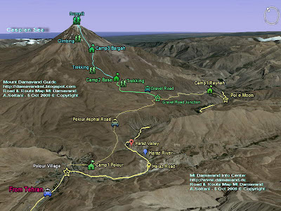
The maps shows you all the ways and footpaths, from Tehran to starting points, camps and to the summit, you will learn how to go to the summit of Iran and Middle East by your own....

South Route Map Mt Damavand
Mt Damavand South Route Map

MDG International
MDG in Your Language
Summary of MDG in Your Native Language . This is an auto translateion of MDG in different languages, later we may add a human translation too. So far we have finished automatic translation for the following languages....

Mountain Sickness
AMS
A family of related medical conditions that sometimes develop when people travel to altitudes above 3500m (11,500ft), at times even lower. There is a wide variation in both the speed of onset, the severity of symptoms and also at the height at which they occur – this is different for each person. The problems are caused by lack of oxygen....

Mummy
On the summit there are few dead frozen animals which look like ancient Egypt mummies, of cours without bandages ! These bodys are there for a long time, more than 20 years. The cause of their dead is not quite known , perhaps they have died becuse of hunger , cold and/or sulphur gas .…

Mythology
Tirgan feast is the day that heroic Iranian archer Arash put his life on an arrow and threw it by a bow from the top of Iran's highest peak Damavand to demarcate Iran's border with Turan. (archer and archery comes from Iranian hero name Arash)...

Nature
Mount nature is fantastic in spring specially for its beautiful red flaowers
At the foot there are a special kind of poppy called the scarlet poppy or papaver bracteatum grows, this beautiful wild red flower covers a vast area around the mountain.…

Mount Damavand Nature,  Damavand poppy fields above clouds, Photo by A. Soltani
Mount Damavand Nature
Damavand poppy fields above clouds
Photo by A. Soltani

News
Heavy Snow Fall 13 April 2009
The snow fall around Lasem is continued this week. Good news for ski mountaineers , but it may delay the climbing season for clmbers.…

Noah
Noah's Ark Discovered in Iran?
July 5, 2006
High in the mountains of northwestern Iran, a Christian archaeology expedition has discovered a rock formation that its members say resembles the fabled Noah's ark. The team discovered the prominent boat-shaped rocks at just over 13,000 feet (4,000 meters) on Mount Suleiman in Iran's Elburz mountain range....

Photo Gallery
MDG Photo Gallery
See beautiful photos in separate album for each category
Recently I have added a numerous number of photos to MDG photo gallery album , the total number reaching about 500, a part from that I have added different albums in different categories in the album...


Mount Damavand Photo Gallery

Pool
There is a small pool in its summit crater in summer. This pool is frozen most of the time, only in a hot summer you may see a little water in it, because of its small size it is regarded as a pool .…

Price
Price and Cost for Tour and Trip
Your timing and itinerary determines the price and cost of your trip to Mount Damavand, you should clarify in what time of the year you decide ascending....

Routes
There are 16 routes , 4 of these routes, south, west, north and north-east are popular, each with a shelter at about 4000m . The north face has an extra shelter at 5000m , the most popular side is the south face, most climber start their ascent to summit from south route. …

Services
We organize and offer the best possible services for your mountain, ecosystem and cultural tours, either as exclusive custom designed tours to best suit your programme or as a single service, just let us know the exact logistic and support you need, we will do our best for you, keep in touch for more info and let's work together to finalize all tour arrangements.…

Shadow
You need a good timing in your ascent in order to witness the beautiful shadow during sunrise midway to the summit , also the chances of the mounatin being free of clouds are highest during the early morning hours. The recommended way of doing this , is to start your climb towards summit at about 4.30 am from Bargah Sevom Camp . …

Ski Mountaineering
Mt Damavand is a popular climbing mountain and is rapidly gaining popularity with ski mountaineers in recent years, mainly due to its height 5671m and easy accessibility from Tehran . It has mild skiable slopes for descents up to 3000m downhill skiing , it is surly one of the world's finest ski mountaineering places.…

Summit
It is conic like many other volcanic mountains , it looks like Fujiyama in Jpan. At the summit there is a crater about 150-200 meters across and 30 meters deep , with a lot of yellow sulfurous rocks and pumice stones , cowerd by snow and ice most of the time, only in a very hot summer you may find a little water in its pool.….

Terms of Payment
Deposit policy for tour
To be registered in MDG event calendar, all clients are requested to pay 50% of their itinerary cost to MDG account as deposit 30 days prior to departure date unless otherwise specified, and pay the remaining 50% balances in cash in Euro on the first day of the tour.…

Thermal Spring
There are many thermal springs with therapeutic qualities, these minral hot springs are mainly located on the volcano's flanks and at the base , giving evidence of volcanic heat comparatively near the surface of the earth . Although is believed to be extinct and while no historic eruptions of the Volcano are recorded…

Timing
Best climbing season
June, July and August are the best climbing season. During these three months, the footpath is usually free of snow, the weather is relatively mild, access by public transportation is easy but the mountain shelters are crowded .…

Mt Damavand South Route beginning of climbing season
Beginning of Climbing Season South Route

Tips and Tricks
A collection of tips and tricks
Climbing to the summit of Middle Eastis a life time memory, ascend to the Summit is technically easy but physically a tough climb, before starting your ascend you better to read some essential info. It ranks beside Kilimanjaro in terms of difficulty and height.…

Tour
Many of you may have dreamed of standing on the roof of Iran and peak of Middle East, we give you this opportunity to try your dream and truly experience the magic of this beautiful volcano, keep in touch for more information, and let's work together to finalize all .…

Damavand Private Tours
Mount Damavand Private Tours

Video
Please wait few seconds for the player to load the video clips. To download the videos click on the links. I will update the album…

Volcanic Activity
Volcanic activity became unusual and much higher than usual in 2007, it has started emitting a great amount of sulphur gas and steam out of its main active part, the photos shows the most active part very closed to the summit in the south route. When reaching that area keep away from these smokes and continue your way up against the wind .…

Vinegar Mask for Volcanic Area of Mount Damavand
Vinegar Mask for Volcanic Area near the summit

Volcanic Statues
There is a ridge in the south route , we call it Statue Ridge (Farsi Name Yaal e Tandis, which you can find many volcanic statues in different shapes and sizes.…

Volcanic Statues of Volcano Damavand
Volcanic Statues

Volcanic Terms
Volcanic and Geologic Terms
A
'A'a: Hawaiian word used to describe a lava flow whose surface is broken into rough angular fragments. Click here to view a photo of 'a'a.
Accessory: A mineral whose presence in a rock is not essential to the proper classification of the rock.
Accidental: Pyroclastic rocks that are formed from fragments of non-volcanic rocks or from volcanic rocks not related to the erupting .…

Volcano Damavand
Located approximately 50 kilometers northeast of Tehran, it is an impressive stratovolcano that reaches 5,670 meters (18,598 feet) in elevation. Part of the Alborz Mountain Range that borders the Caspian Sea to the north, Damavand is a young volcano that has formed mostly during the Holocene Epoch ...

Warning
Please be advised it is not recommended to use any unidentified place as your resting place either in the mountain or in the city-villages near the mountain. The safest , the cheapest , and the best resting place for you are Iranian Mountaineering Federation Camps . If you need a reliable and trusty resting place when you travel from Tehran to the mountain we recommend you to use these camps ONLY …

Weather
For Weather Forecast visit Snow-Forecast it is about 80% correct …

Winter Climb
This mountain is a popular mountaineering peak for summer, it is surly one of the most difficult ones in the world for winter climb, despite its mild climbing ridges and lack of technical difficulties, freezing weather and strong winds makes ascend very difficult .…

World Heritage
Mount Damavand will be registered on the national heritage list as the first natural monument across the country on July 29.Mount Damavand is a dormant volcano and the highest peak in Iran with a special place in the Persian mythology and folklore.…

Home MDG880804D
Copyright © Mount Damavand Guide . All rights reserved.