damavand-routes
Routes
Mt Damavand has 16 identified climbing routes on different faces with various climbing grades and difficulties, four of these routes are common for climbing, north, east, west and the south, each with a shelter/refuge at about 4000m, the north face which is the most difficult side has an extra shelter at 5000m. There are also some risky and none safe routes which are of less significant.
South Route
The south routh is the most popular side and many climber prefer to ascend from this face because it has some advantages such as very good huts, easy and quick accessibility and approach from Tehran, it is almost a shortcut to the mountain.
Difficulty and climbing grade
Route type is basic mountaineering, moderate walk-up and easy descend.
Campsites
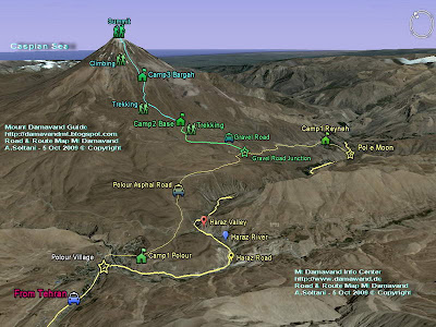
Camp 1 Polour Hut
Camp 1 Reyneh Hut
Camp 2 Base Shelter, Goosfand Sara, Mosque
Camp 3 Bargah Sevom Shelter,
Camp 3 New Hut
How to go there
Tehran> Haraz Road> Polour Village> Camp1 Plour Hut> Base Camp
or
Mazandaran Province> Haraz Road> Reyneh Town> Camp1 Reyneh> Base Camp
Note
Most climbers who ascend to the summit from West, North East, or North Face prefer to descent from south face because of its easy descend footpaths !!

Mount Damavand South Route Map
West Route
This route has a very long access by car to the starting point and it is the second popular side of the mountain, but the distance from starting point to the Simorgh Camp is quite short.
Difficulty and climbing grade
It is a basic mountaineering, moderate walk-up, basic snow and cold, difficult descend.
(Farsi name for this camp is Panagah Simorgh).
Campsite
There is a new double stage shelter/refuge called Simorgh at about 4200m in this area.
How to go there
Tehran > Haraz Road> Polour Village> Camp1 Plour Hut> Simorgh Shelter
Note
Simorgh means Roc, the name comes from Iranian tales and refers to a gigantic legendary bird, said to carry off animals as big as elephants for his food.
East Route
This route also called the North-East Ridge, is the longest route to the summit and the third popular side of the mountain.
Difficulty and climbing grade
Route type is mountaineering with difficulty, hard ascend cold and windy, long descend.
Campsite
There is a shelter/refuge called Takht e Fereydoun Camp at about 43oom.
Persian name for this camp is : Panagah Takht e Fereydoun.
How to go there
Tehran > Haraz Road> Nandal Village> Takht e Fereydoun Shelter .
North Route
The north face is the most difficult side of the mountain.
Difficulty and climbing grade
Scramble mountaineering, steep, hard ascend, depending on season, cold and windy, snow & ice , difficult descend,
Campsites
There are two shelter/refuge on this route
Camp1 called 4000
Camp2 called 5000

Mt Damavand south route GPS Landmark Table
More in MDG
Mt damavand camps, iran mountain camps, mount federation iran campsites, resorts, shelter, panagah, refuge, lodge, hotel, hostel, suite, mountain resort, north east camp panagah tahkt feridon shelter, tahkt e fereydon refuge, west camp panagah simorgh shelter, simorq refuge, first camp, second camp, mid camp, last camp, camp1 polour, camp1 reineh hut, camp2 base shelter, base camp refuge, goosfand sara, saheb al zaman mosque, camp3 bargah sevom refuge/shelter, camp3 bargah new hut.
Technical info, gps landmark, gps track, gps waypoint, gps guide, gps iran, gps landmark iran mountain, route and trail map, foot stamp, route news 2010 iran, route map, trail map, photo damavand, foto, picture, pic, video, news, google earth route, south, east, west, north face, google earth satellite image iran, virtual tour google earth, info iran, maps and signs, shelters and huts route map, trekking and expedition route map, hiking & trekking map, trail map, how to go, how to reach, how to climb, climbing route, tehran to damavand, distance tehran to, facts and figures.
Routes MDG27JAN10A
Copyright © Mount Damavand Guide . All rights reserved.
Labels: Routes
0 Comments:
Post a Comment
<< Home