GPS Track 2
Useful for Mountaineering, Ski and Snowboard
27 November 2010 Posted by Sherppa
There is a descend (return) route on the south face of Damavand Mountain called Shen Ski (soft type of soil), it is a comfortable way to go down especially for tierd mountaineers who return from a tough climb, also it is the best down hill track for wild ski mountaineering and freestyle snowboarding.
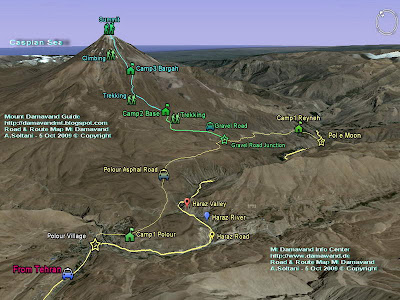
This descend route is located between Damavand summit 5671m and the Camp3 New Hut 4250m, the covered area has a mild climbing slope without rocks and guideposts, it is the easiest return way of the mountain, in good visibility you can find your way back easily.
This GPS track file is ideal for:
A- Descend in Summer
Climbers who have summited successfully and prefer an easier way down to avoid rocky parts, suitable when the valleys are free from ice and snow and the the ground is covered with soft sands.
Please remember this track is slightly different from ascend route and is not recommended for climbing up! It is suitable for descend only. (The green line on the following map shows the ascend track).
B- Ski Mountaineering and Snowboarding in Winter
The best track for Ski Mountaineers and snowboard lovers to enjoy 3000 meters long distance and 1400 meters altitude downhill ski in snow during the winter and go down from the peak to campsite3.
Shen Ski GPS Track File in GPX Format
(Damavand summit to Camp3 New Hut)
by Garmin Oregon 550 Navigator
Download
Warning
In bad weather and stormy situation, poor visibility or darkness, it is not safe to go upper than the fake summit 5400 meters without a reliable navigation unit like a handheld GPS receiver.
Visit Also:
GPS Tracks for Mt Damavand Iran.
GPS Landmarks.

GPS Tracks Mt Damavand Itan

Mt Damavand South Route GPS Track
More in MDG
Damavand iran, how to climb, warning for mountaineering, equipment list, trail and climbing map, gps coordinates, way point to the peak, google map, google earth satellite image, damavand volcano winter climbs and ski mountaineering tour 2011, Garmin Oregon 550 Navigator, GPS satellite tracking system.
Continuous tracking,damavand climbing and ski season iran, dizin and shemshak ski resorts iran, local ski tour guide, ski touring, iran mountain and ski guide, ski expedition, mount tochal ski resort, how to hike in iran, how to get to the mountain, damavand weather forecast.
Damavand expedition tour 2011, ski resort and piste, touring information, adventure tours, hiking trekking, ski tour, climbing tours, travel map, guided tour 2011, sightseeing iran natural attractions, ecosystem tourism, touring organization, travel agency.
GPS Track Files - Descend MDG27NOV10
Copyright © Mount Damavand Guide . All rights reserved.


