28 March 2023

Damavand Tours

 Mount Damavand Tours
What distinguishes hiking, trekking, backpacking, and mountaineering in Damavand?
All Mount Damavand toursmountaineering, hiking, backpacking, and trekking—involve walking outside, even though they differ in terms of difficulty, duration, and equipment requirements. Before moving on to climbing and trekking excursions as they gain experience and skill, beginners may choose to start out on a hike or backpacking trip in the Damavand mountain. In this post, we'll outline the main distinctions. 


Mount Damavand Trekking Tour Guide


Damavand Hiking Tour
A hiking journey to Mount Damavand comprises a leisurely stroll along an accurately marked route or trail, usually over level ground. Most hiking trails are well-maintained and prominently marked, and hikers may often complete the route in a day or a few hours. The majority of hikers bring a daypack with them that is filled with extra clothing, food, and water. Visiting the Mount Damavand poppy field or a Damavand Campsite for a day trip.


Mount Damavand Trekking Tours


Damavand Trekking Tour
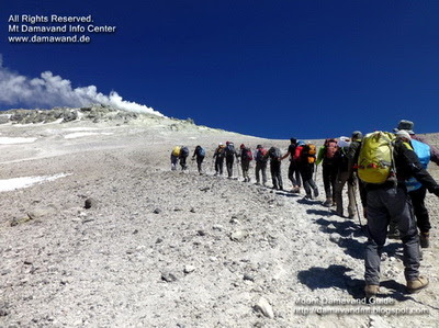
Walking for days on end over challenging terrain, usually in secluded locations, is required for the more demanding form of hiking known as the Mount Damavand trekking tour. Trekkers must bring all of their equipment and food with them because the trails for trekking sometimes need to be more clearly designated than the pathways for hiking. On a trek, it is possible to camp, stay in a lodge or tea house, and cross rivers and streams. A multi-day climb to and from the peak of Damavand serves as an illustration.


Damavand Backpacking Tour
The Damavand mountain backpacking excursions usually entail carrying a heavier load for longer periods, frequently for several days. Backpackers must be self-sufficient and bring all of their equipment with them, including a tent, sleeping bag, stove, and food. Backpacking frequently entails camping in remote, natural areas. A multi-day backpacking trip to Damavand summit and Lar National Park might be an example.

Damavand Mountaineering Tour
The most complex and technical of the four activities is climbing Mount Damavand or taking a mountaineering excursion. It entails employing specialist equipment and climbing techniques to scale the Damavand mountains, frequently covered in ice and snow throughout the winter. Physically fit, technically adept, and knowledgeable in rope work, navigation, and avalanche safety are all requirements for mountaineers. Extreme elevations, overnight camping, and exposure to unfavourable weather conditions can all be part of mountaineering. For instance, a multi-day mountaineering expedition for winter climbing on the Damavand north face route or ice climbing on the Damavand Glacier.


Mount Damavand Iran


Damavand Tours the Significant Variations?

Difficulty: The four outdoor sports of hiking, backpacking, trekking, and climbing are ordered from least to most physically taxing in terms of Damavand difficulty.

Itinerary: Journey time to Mount Damavand on the itinerary hiking excursions can take anywhere from a few hours to a few days, unlike backpacking and trekking trips, which can extend for days or even weeks. Expeditions in the mountains could last for several more days.

Equipment: Damavand hikers just only the very minimum in comparison to backpackers, trekkers, and mountaineers who require more specialized gear including a backpack, sleeping bag, and cooking stove. In addition to safety equipment like boots and coats, mountaineering requires specialized instruments like ice axes, crampons, and ropes.

Safety: Hiking in the Damavand Mountains is occasionally thought of as risk-free when contrasted to backpacking, trekking, and climbing, which involve higher threats like falls, avalanches, and altitude sickness. The four sports are all dangerous, but climbing is the riskiest and calls for the most caution.


Damavand Tour

Sources of information for hiking trekking and climbing tours to Mount Damavand, Iran.
Mt. Damawand summer expedition tour.
Damavand climbing & mountaineering tour.
Mt. Damavand economy tour.
Damavand climbing tour package.
Mount Damavand hiking trekking and climbing tours.
Damavand economy hiking tour.
Private Damavand mountaineering tour.


Damavand Tour 23MDG0328A


19 March 2023

Damavand Facts & Info

 Damavand Facts
Mount Damavand Facts. Informational facts, advice, and instructions for climbing Mount Damavand. All the information you need to know about Damavand, including statistics, information, weather predictions, hiking routes, climbing excursions around Damavand, necessary equipment, and more.

Mount Damavand Facts & Info
Damavand Facts & Info

Since Damavand is a conical volcano, there are four well-known hiking routes and numerous angles from which it can be climbed. Damavand Peak, which is frequently surrounded by clouds, is significant in Persian mythology and folklore. More than one of the nation's incredible natural wonders can be found in Damavand. In a clear sky, Tehran and as far as 250 kilometres away can both see the Damavand top. Another name for this enormous volcano in perfect cone shape is Damavand Volcano. It is situated on the southern shore of the Caspian Sea in the northern part of Iran, in the centre of the Alborz Mountain Range. The height of Damavand Mountain is 5670 meters above sea level (See also Damavand Height by our GPS Measurement). The Damavand Volcano is the second-highest volcano in the northern hemisphere and the tallest volcano in Asia.

Facts, Information and a guide for trekking in Damavand

Damavand Trekking Facts & Info
Facts, Information and a guide for trekking in Damavand
• Elevation Gain: 2670 meters (8760 feet).
Climbing Season: July through September is a prime trekking season.
• Best climbing itinerary: The best trekking itinerary is three to five days long.
• Best starting day: The best days to start are Saturday and Sunday. Visit Damavand Crowd.
• Best starting Damavand Campsites: Polour Campsite is the ideal starting point for the south and west routes. For the north and northeast routes, Nandal Camp.
• Climbing Season: All year long for seasoned climbers. From mid-June to mid-September is the best time for average climbers.
• Difficulty: Damavand's southern route difficulty is a considerable amount of uphill hiking.
• Easiest Hiking Path: In the summer, the southern path is a good place to go hiking and trekking.
• Moderate Trekking Route: The west path is an easy trek with a gradual ascent and a difficult descent.
• Longest Mountaineering Route: The longest mountaineering path is on the northeast side, along the Gazaneh trail.
• Hardest Climbing Route: The North Face is the most difficult scrambling climb.
• Hiking Distance: The base camp of the Goosfand-Sara South Way is about 8 kilometres from the summit (about 10 hours).
The conventional south path is the most well-liked route.
• Climbing Guide: The Damavand Guide Team is the most knowledgeable guiding team for trekking tours in Damavand.


Information and Facts for Trekking Tour Damavand


Detailed Information and Facts for Ski Touring Damavand
It depends on the weather and snowfall.

• Snow availability and ski season: December to mid-May. Skiing is most enjoyable in March and April.
• Best Ski Route: Damavand South Route Ski Resort is the best ski path.
• Best ski program: Seven-day ski itinerary.
• Snow Depths: 2 to 5 meters of snow cover
• Vertical Ski Drop: A maximum of 3000 meters can be skied vertically from the summit to the asphalt road.
• Total Skiable Distance: Peak to asphalt road distance is best around 12000 meters for total skiable distance.
• Ski Guide: The Damavand ski guide team is the most knowledgeable guiding team for ski touring and ski climbing.


Facts about Iran's Mount Damavand


Facts about Iran's Mount Damavand in Brief
Informational facts, advice, and instructions for climbing Mount Damavand.

• Height: 5,670 m (18,600 feet) (see my GPS measurement).
• Listing: It is listed in the Seven Volcanic Seven Summits (V7S).
• Location: Mazandaran Province, Iran.
• Mountain Chain: Alborz Mountains.
• Prominence: : 4,667 m. It is recognized as the world's 12th most prominent summit.
• Routes: There are four major Damavand trekking routes: the north route, the west front, the south route and the north-east side
Volcanic activity: It currently possesses thermal springs at the base and releases sulfuric gas from its summit.
• Peak location: Latitude and longitude coordinates, Lat: 35.954466°, Lon: 52.110020°.
• Nearest airports: IKA Airport and Mehrabad Airport.
• Last eruption: Around 5,300 BC was the last eruption.
• Symbolism: Damavand Mountain represents Iranian resistance to foreign occupation in Persian poetry and literature.
• Rank: The Damavand volcano is the third-highest of the volcanic seven summits (V7S). It is also the tallest mountain in Iran and the middle-east, the second-highest mountain in the northern hemisphere, and the tallest volcano in Asia. In terms of prominence, Damavand Mountain is the world's 12th-highest summit. 

Damavand Facts 23MDG0319A

13 March 2023

Damavand Ski

Difference Between Damavand ski touring and ski mountaineering!
Why is Damavand ski touring different from Damavand ski mountaineering?
Understanding the many types of skiing, ski touring, and ski mountaineering vacations in Damavand Ski Guide. Ski touring and ski climbing are available in the Iranian highlands. The Damavand ski touring and ski mountaineering skills are used for backcountry skiing in unmarked or unpatrolled isolated terrain. Ski mountaineering is more challenging and dangerous, and it requires more knowledge and equipment. The primary difference is that Damavand ski mountaineering has more difficult terrain, such as steep slopes, glaciers, rocks, and ice that must be traversed by skis.


Alpine skiing in Damavand is harder, riskier, and more expensive to successfully ski mountaineer at Damavand. The key distinction is the more difficult terrain, which includes steep slopes, glaciers, boulders, and ice, that must be traversed in order to reach the peak of Damavand by ski. Acclimatization and practice ski mountaineering may also be part of the ski mountaineering program at other summits, such as Alam-Koh summit, the Doberar ridgeline, which includes Bazmchal top, Chengizchal peak, Parvaneh summit, Angemar pinnacle, Mount Doberar, Suzchal top, etc. The peak of the Doberar or Damavand mountain ranges may need to be reached by Damavand ski mountaineers using climbing methods and equipment before they can ski back down.


The majority of Damavand ski touring takes place on less exposed slopes and doesn't require much climbing skill. The Damavand ski tour is a better option for beginners compared to ski mountaineering. Ski touring is a method of reaching a Damavand campsite, such as Camp 3 Bargah Sevom Shelter, that may be accomplished on easier terrain and doesn't call for highly developed skiing or climbing abilities. To acclimatize and be ready for Damavand ski touring, you can ski in the ski resorts listed below, including Mount Tochal ski resort, Dizin ski piste, Shemshak ski slopes, Gole-Zard peak, and the distant Lasem village backcountry area. Before attempting ski touring up Damavand Mountain, beginners should train at these resorts to get acclimated.

Damavand Ski 23MDG0313A

03 March 2023

Simorgh Shelter

 Simorgh Shelter
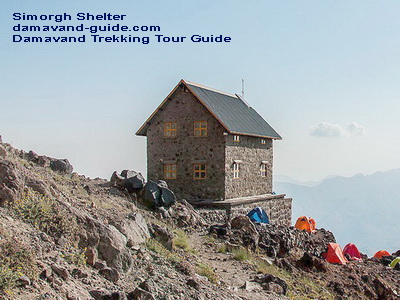
The Simorgh Shelter or Simorgh Refuge is a Damavand Camp which located on the western trekking trail of Iran's Mount Damavand, Iran. Simorgh Camp's two-story building gives room for about 40 climbers. It is possible to pitch up at least 40 to 50 tents at a tenting campsite next to the Simorgh refuge (latitude: 35.9564°, longitude: 52.0825°, elevation: 4,200 m), making it suitable for climbers even on busy days. The Simorq mountain shelter has lighting both inside and outside that is powered by solar energy. There is currently no water in the shelter's outdoor restroom. The snowmelt flowing water, which is 150 meters northeast of Simorgh camp, is the only water source in this mountain camp site.


Mt. Damavand West Trail Climbing Tour Guide
Simorgh Shelter lat: 35.9564° – lon: 52.0825° – alt 4,200 m


You can also Climb Damavand by going west. After the traditional south path, it is the mountainside that sees the second-highest number of climbers. You must first travel to Polour Camp from the Haraz Road if you want to hike Damavand from the western front. Off-road vehicles from Polour can transport you through Lar Road and to the starting point of the Damavand West Trekking Route, also known as the Parking Area or Damavand West Route Basecamp, throughout the summer. The ascent often begins from Vararood's west front base camp to Damavand.


Mount Damavand Iran West Route Trekking Tour Guide
Simorgh Shelter lat: 35.9564° – lon: 52.0825° – alt 4,200 m


This base camp (Parking Area) is located at an altitude of around 3400 meters above sea level. To get to Simorgh shelter, you must hike from the parking lot. The Simorgh camping area has running water, which is a useful amenity. Spend the night in the tenting area or the Simorgh shelter. The climb from the parking lot to the Simorgh shelter takes about 3–4 hours. Depending on your physical condition, ability to breathe, and level of readiness, it could take you anywhere between 5-7 hours to reach the west summit of the Damavand volcano crater from Simorq shelter.


Damavand West Route Mountaineering Tour Guide
Simorgh Shelter lat: 35.9564° – lon: 52.0825° – alt 4,200 m


Simorgh Shelter MDG 23QUI0303A

Best Mount Damavand Climbing Experience with Local Guides

  Best Trekking & Ski Youring Guides in Mount Damavand’s Adventure The Role of Certified Guides in Mount Damavand’s Unique Adventure. Th...