03 January 2010

Bargah


Camp 3 Bargah
Mt Damavand South Route Campsites
Bargah Sevom shelter is an old refuge located at altitude 4220 m, this small camp was the main safe haven and mountain resort on the south face for many years before the New Hut was made in 2009 in this area. This shelter is a good resting place for off season, but it is not suitable in summer because it is too crowded and dirty.

Bargah Sevom shelter/refuge is losing its popularity and usage to the new hut. In this campsite you can find some food, water, rent tent and sleeping bag in summer, but it is a good idea to bring your own stuff.

For more comfort and privacy in summer it is highly recommended to bring and use your private tent, or use the benefit of the new hut which has started to give services to climbers since 2009, you may book and use its very comfortable private rooms.

Mt Damavand Camp3 Bargah Sevom Shelter
Damavand Camp3 Bargah Sevom Shelter (yellow)

Facilities and Advantages
- In a bad weatherit is a safe haven.
- For off-season it is a good place for acclimatization and accommodation .
- This refuge has some bunk beds.
- Running water is avalable in summer.
- Mobile network avalable.
- In summer some food, drink and water avalable.
- outside toilet.

Disadvantages
- Small old shelter with no facilities.
- Noisy, very crowded and too dirty in summer.
- Not a suitable plcae for acclimatization in summer.

Quick Facts
Altitude 4220 m

Coordinate
Latitude 35-55-54 N
Longitude 52-06-30 E

Location
Distance from Base Camp 4 to 6 hours
Ascent to summit 5-7 hours
Descent from summit 2- 4 hours
See also Damavand GPS Landmark.

Impotant Note
This is the last campsite of the south route, and there is no more hut or shelter above Bargah Sevom refuge and the new hut.

Mt. Damavand Camp3 Bargah Sevom Shelter/Refuge
Mt Damavand Camp3 Bargah Sevom Old Refuge
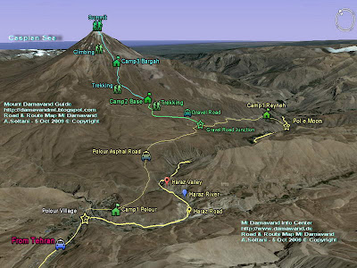

South Route Map Mt Damavand
Mt Damavand South Route Map


Damavand Camp 3 Bargah Sevom Camp 4220 m

More in MDG
All mt damavand camps, iran mountain camps, iran mout federation camps and huts, base camp refuge, base camp shelter, mosque, goosfand sara, camp 3 hut, mount resort, panagah simorgh shelter, panagah takht feridon, hiking & trekking tour 2010 iran, tour damavand iran, gps landmark, route map, photo, picture and video, news, google earth image, hostel, hotel tehran, suite iran, weather and climate damavand دماوند ایران.

Camp 3 Bargah Sevom Shelter MDG3JAN10C
Copyright © Mount Damavand Guide . All rights reserved.

Base


Camp 2 Base
Mt Damavand South Route Campsites
Base camp is a mountain camping site located at altitude 3040 m above sea level and is the starting point for summer trekking to Mt Damavand. In this area you may find a small mountain shelter or refuge, a mosque called Saheb Zaman (or Saheb al Zaman) and a sheepfold.

In summer and climbing season, strong cars like 4WD Jeeps and land rovers transfer climbers and their equipment to this campsite, it is possible to find some water, food and drink, but it is recommend to bring and use your own staff and also you may find mule and porter to carry your equipment to the last camp.

Remeber in other seasons, this area is almost remote and restricted and due to heavy snowfall the gravel road is blocked and cars may not be able to reach this place, the starting point in winter is gravel road junction (GPS Landmark No5) or somewhere closed to that point.

This place is not recommended for any accommodation and acclimatization in summer and crowded climbing season, but if you insist to use this place, you may bring your own tent and use it few hundred meters away from the area, in other seasons when it is not too crowded you can use the shelter/refuge or the mosque with no problem.


Base Camp Mount Damavand
Mt Damavand Base Camp or Goosfand Sara 3040 m

Facilities and Advantages (mostly in summer season)
- South route starting point.
- Transfer by car to this place.
- Mobile network available.
- Mule and porter available.
- Some food, drink, water.

Disadvantages (mostly in summer)
- Worst campsite it area, it need some major reconstruction.
- An old shelter/refuge with no facilities.
- Not a suitable place for acclimatization and accommodation.
- There is no running water most time.
- Noisy and crowded and too dirty.
- Not a suitable place for foreigners traveling to this mountain.
- In fact it is invaded by people, cars....
- No proper toilet.
- No management at all.

Note Remember for acclimatization, it is recommended to use Camp 1 Polour or Camp 3 New Hut.
See also Warning.

Altitude 3040 m

Coordinate
Latitude 35-54-10 N
Longitude 52-06-34 E

Other Spelling and Names
English name, Base Camp, Mosque, Base shelter/refuge, sheepfold.

Farsi Name, Goosfand Sara ye Ehsan, Masjed Saheb al Zaman,

Old name: Alaf Chin
Gosfand Sara means sheepfold.

South Route Map Mt. Damavand
Mount Damavand South Route Map


Road Map Tehran To Mt Damavand
Road Map Tehran To Damavand


Mt Damavand Camp 2 Base 3040m

More in MDG
All iran mount federation camps and resorts, base shelter, bargah sevom refuge, saheb al zaman mosque, camp 3 new hut, simorgh shelter, panagah takht feridon refuge, route map, summer itinerary, photo, picture and video clips, mountain guide, guided, iran nature and ecosystem guide, ski tour, ski mountaineering tour 2010, mt. damavand, winter climb and ski in 2010, volcano damavand, damawand, demavand, damavan, climate and weather damavand iran دماوند ایران.

Camp 2 Base MDG3JAN10B
Copyright © Mount Damavand Guide . All rights reserved.

Reyneh


Camp 1 Reyneh
Mt Damavand South Route Campsites
Reineh hut is the oldest Mt Damavand campsite, it was build in 1939 and reconstructed in 1969, since then there has been no major changes in this building, this small old camp is located in Reyneh Town and it was the only main mountain resort in the area for many years before the construction of Camp 1 Polour in Polour Village in 2004. In recent years among Iranian climbers and foreign tourists, Reineh hut has lost its popularity to the new hut.

If you want to go to Damavand from north of Iran, either from Mazandaran or Gilan or province, you may use the Reineh as your starting point to the south route, but if you travel through capital Tehran, you have a better option and you are recommended to use Polour Hut which is much better place and a shortcut to the Base Camp.


Camp 1 Reineh Mount Damavand
Mt Damavand Camp 1 Reineh

Advantages- Access way to the south face from north of Iran, ie Mazandaran and Gilan province.
- Old and ordinary camp for accommodation and acclimatization.
- Shared rooms with bunk beds and private suite.
- Cooking equipment and kitchen.
- Central heating.
- Telephone line and electricity.
- Water taps, cold & hot, shower and toilet.
- 2 Mobile networks available in the area.

Disadvantages- Longer access from Tehran compared to Polour Hut.
- A small hut with little facilities compared to Polour New Hut.
- This old camp need some reconstruction.
- Needs better management.

Important Note
Please note, it is not recommended to use any unidentified place  as your accommodation either in the towns or villages near the mountain. The safest and the best resting place are Iran Mountain Federation Camps ONLY.

Coordinate
Altitude: 2078 meters
Latitude: 35-52-58 N
Longitude: 52-09-58 E

Reineh Town
Rineh is a beautiful small town located in south slopes and at foot of Mt Damavand in Mazandaran province, Iran. It is the capital of the Larijan district of Amol County.

Alternate Names and spellings
Reineh City, Reyneh Town, Rayneh, Reneh, Rehneh.
In Persian رینه، شهر رینه ( pronounced ray ne)


South Route Map Damavand mount
Damavand South Route Map


Mt Damavand Camp 1 Reyneh

More in MDG
Mount federation campsites iran, base shelter, panagah, refuge, resort, shelter, hostel, hotel, suite, camp 1 polour, camp 2 base shelter, mosque, goosfand sara, camp 3 bargah sevom, camp 3 new hut, first camp, second camp, mid camp, last camp, simorgh shelter, takht feridon shelter, ski mountaineering tour 2010 mt damavand iran, tehran to damavand, gps track, gps waypoint landmark, route and trail map, photo, picture and video, news 2010 iran, google earth, winter climate, hike, trek, climb, damavand iran دماوند ایران.

Camp 1 Reyneh Hut MDG3JAN10A
Copyright © Mount Damavand Guide . All rights reserved.

02 January 2010

Polour


Camp 1 Polour Hut

Mt Damavand South Route Campsites
Polour Hut or Lodge is a comfortable hostel and a cosey place for acclimatization and accommodation in the area, it has some shared bed rooms with bunk beds and 2 private suite, it is scheduled to be open through the year, but it is highly recommended to reserve and book your place in advance in the summer season and crowded holidays.

This new complex sport center is the best starting point for climbing Mt Damavand either from calsic south route or the west route, it was established in 2004 by Iran Mount Climbing Federation, it is located in Polour Village closed to Haraz Road in Larijan district of Mazandaran Province Iran.

Mount Damavand Camp 1 Polour
Mt Damavand Camp 1 Polour Altitude 2270 m

Advantages
- A shortcut to Base Camp.
- Suggested starting point for south and west routes.
- Best place in the area for acclimatization and accommodation.
- Private suites and shared rooms with bunk beds .
- Cooking equipments and kitchen.
- Tap water, telephone line and permanent electricity.
- Good toilet and showers, cold & hot water taps.
- 2 mobile network avalable in the area.
- Central heating, it is quite warm and comfortable in cold weather .
- Water, some food and soft drink and mountain gear avalable.
- Good management.

Disadvantages
There is no major disadvantages for this beautiful mount resort, but it is gaining popularity which could make it crowded in the peak of climbing season and you should book your room in advance.

Quick Facts
Altitude 2270 m
Coordinate
Latitude 35-50-50 N
Longitude 52-03-36 E

Note
Haraz Road is one of the main roads which passes through Alborz Mountains and connects capital Tehran to north of Iran and the Caspian Sea in Mazandaran province, this road passes by Mt.Damavand through beautiful Haraz Valley closed to Haraz River.

Other Names and Spellings
Panagah polor, Polur resort, poolor hostel, poolour lodge.

South Route Map Damavand
Mount Damavand South Route Map


Road Map Tehran To Damavand
Road Map Tehran To Mt Damavand


Damavand Camp1 Polour Hut Altitude 2270 m

More in MDG
Iran mountain federation campsites, refuge, resort, shelter, hostel, hotel, suite, village, north east tahkt feridon shelter, west simorgh shelter, reyneh, base camp, bargah sevom camp, bargah sevom new hut, hiking & trekking ecosystem and iran nature tour 2010, gps landmark, route and trail map, itinerary 2010 damavand mt iran, guided tour, ski and climbing tour iran, winter climb and ski mountaineering, news 2010 iran, google earth sat image, south, east, west, winter climate and weather damavand iran دماوند ایران.

Camp 1 Polour Hut MDG2JAN10B
Copyright © Mount Damavand Guide . All rights reserved.

Alborz


Alborz

Alborz Mountain Range is located in northern Iran and is extending from west to east of the country, it is a natural barrier between the Caspian Sea and the central plateau of Iran.
Many peaks are given the name Alborz, such as Mount Elbrus in the Caucasus Mountains, and Mount Elbariz (Albariz) in the Kerman, also there is a peak in the Hindu Kush, near Balkh, called Mount Elburz, these names come from Alborz mountains in Iran. This range is made of sedimentary series, it has a forests ecoregion on the northern slopes in the Caspian Sea zone.
The artificial images in this article are made by Views of the Earth by using computer rendering techniques.

Alborz Mountains, Caspian Sea and Damavand
Mount Damavand in the Alborz Mountains
See full size image by Views of the Earth

Due to the heavy snowfall in winters there are many ski resorts in Alborz, which some are among the best in the word for either on-piste or off-piste and wild ski mountaineering.

Major Ski Resorts in Alborz Mountains Iran
AbAli ski resort, piste, Haraz Road, Tehran
Darbandsar ski resort, piste, Karaj,Tehran
Dizin, grass ski piste,, Karaj,Tehran
Dizin ski resort, piste,, Karaj,Tehran
Lasem, off piste ski area
Mt Damavand, off piste ski zone, Mazandaran Province, Iran
Shahmirzad, Semnan Province
Shemshak ski resort, piste, Karaj,Tehran
Tochal ski resort, piste,Tehran Iran

Quick Facts
Lenght: about 1500 km long
Width: varies betwee 30 to 130 km
Highest Peak: Mount Damavand 5671 meters
Avarage height: about 3000 meters
With many peaks above 4000 meters

Famous peaks in Alborz Mountain Range
Central Alborz Range
Mt Damavand 5671m
Mt Azad Koh 4395m
Mt Kholenow 4375m
Mt Nazer (Leghas) Bozorg 4350m
Mt Palan Gardan (Paloon Gardan) 4250m
Mt Koloon Bastak 4200m
Mt Sarakchal 4150m
Mt Vorvasht 4100m
Mt Kharsang 4100m
Mt Tochal 3960m
Mt Mehrchal 3920m
Mt Atash Kouh 3850m
Mt Shahneshin 3850m

West Alborz Range
Mt Sialan 4250m
Mt Shah Alborz 4200m
Mt Khash e chal 4180m
Mt Kehar 4040m

Takht e Soliman (Soleyman) Range
Mt Alam 4850m
Mt Khersan Shomali (North Khersan) 4680m
Mt Khersan Jonobi (South Khersan) 4660m
Mt Takht e Soliman (Soleyman) 4660m
Mt Siasang 4610m
Mt Haft Khan 4540m
Mt Chaloon 4515m
Mt Siagook Jonobi (South Siagook) 4500m
Mt Siagook Shomali (North Siagook) 4445m
Mt Siakaman 4470m
Mt Shaneh Kouh 4465m
Mt Kolahoo 4410m
Mt Gardoon Kouh 4400m
Mt Mian Sechal 4350m
Mt Lashkarak 4255m
Mt Zarin Kouh 4200m
Mt Alanehsar 4050m
Mt Karma kouh 4020m
Mt Pasand Koh 4000m
Mt Sializ 3975m

Other Names and Spellings
Alborz in Farsi البرز, رشته کوه البرز , Alburz, Elburz and Elboroz.

Alborz Mountains, Caspian Sea and Mt Damavand
Alborz Mountain Range, Caspian Sea and Mt Damavand
Fantastic work by Views of the Earth
See full size image by Views of the Earth

More in MDG
Volcano damavand iran, route map iran, eco, adventure, nomadic and outdoor activity tours 2010 iran, hiking & trekking, bird watching and camel riding tour iran, zagros, dena, sabalan, alam Kouh climbing tour, iran desert safari, iran ski mountaineering tour 2010, iran tour operator, touring and tourism, persian cultural tours, travel to persia, damavand iran 2010.

Alborz MDG2JAN10A
Copyright © Mount Damavand Guide . All rights reserved.

Acclimatization


Acclimatization

Mt Damavand difficulty and climbing grade is the same as Mt Kilimanjaro 5895 m, the highest peak of Africa in Tanzania and also similar to the Mt Everest base camp 5380m in Himalaya Ranges.
Generaly speaking, ascending to the summit is not technically difficult, but physically a tough climb and you should be fit enough to try this huge volcano.

The main challenge is acclimatization and the fact that as you gain altitude the air gets thinner with less oxygen, so to prevent or reduce the risk of AMS and increases you chance of success and to enjoy a safe ascend to the summit, it is essential to have a proper acclimatization before your attempt.
Remember that Camp 2 Base (also known as Goosfad Sara) is not a suitable place for accommodation and acclimatization in summer because it is too crowded and too dirty, you better use camp1 and Camp3 only.

How to Acclimatize ?
This is an ideal suggestion for acclimatization in summer season.
There are many different ways for a long term itinerary, but for a short form plan we suggest the following which has been tested successfully many times for our incoming tours and we believe it is quite good for foreign climbers who intend to attempt Mt Damavand in a short program.

Mount Damavand Camp 1 Polour
Mt Damavand Camp 1 Polour Altitude 2270 m


Mount Damavand Camp3 New Hut
Mt Damavand Camp3 New Hut 4250m


Damavand Mt Iran
Mt. Damavand Camp3 Bargah Sevom and New Hut

Day 1 - Arrival Day + Acclimatization
The incoming tourists usually arrive early morning in Tehran, about 1 to 4 AM local time in IKA Airport Iran.
In the first day of your itinerary it is a good idea to go directly by car from airport to Camp 1 Polour altitude 2270m, you may just relax there and rest a day for acclimatization and sleep over night in the camp, no climbing or hard activity and no pollution of Tehran weather. Polour Camp in Polour village is the best starting point for Mt. Damavand calsic south route and the west route and a acomfortable accommodation place in the area.

Day 2 - Climb to Camp 3 New Hut + Acclimatization
In the second day of your programme you can go by car to Camp 2 Base 3050 m, this car transfer lasts about one hour and if you start 7 t0 8 AM in the morning you have plenty time to reach the 3rd camp, start your trek from base camp and by 4 to 6 hours slow walk go to Camp 3 New Hut 4250m, use the rest of the day for acclimatization, over night in the New Hut.

Day 3 - Summit Day
In the third day you are almost ready for a safe try to Mt Damavand summit, You better to start at about 5 AM.
See also Common Mistakes, How To Climb

Day 4 - Reserved Day
Always reserve a spare day for acclimatization and/or bad weather. If you need more time to acclimatize, in the 3rd day you can go up to nearby heights and go back to camp3 and stay one more night there and attempt to the summit in the 4th day.

IKA Airport Tehran Iran
IKA Airport Tehran, Iran
IKA Airport Tehran Iran

More in MDG
Accommodation & acclimatization damavand iran, AMS, acute mountain sickness, common mistakes in mout climbing, how to climb, iran mount federation camps, camp, hut, shelter, refuge, tent, lodge, bunk bed, mosque, hotel, hostel tehran iran, info, itinerary, reyneh town, hiking & trekking, damavand expedition, climb iran, tourism nature iran, travel, ika airport tehran iran, mehrabad airport tehran, ika airport to mt damavand, tehran to damavand.

Acclimatization MDG1JAN10A
Copyright © Mount Damavand Guide . All rights reserved.

29 December 2009

Winter


Winter Climb

Mt Damavand is located in the northern hemisphere and is effected by the Climate of this half of the globe, the winter condition usually start from November or December and last till April or March, the quantity of snow is different each and every year, it is suggested to check the snow news and condition in advance before your challenge.

The climbing grade and Difficulty of Damavand in winter is very tough. There are many winter attempt to this Summit each year, mostly unsuccessful and only a few successful climb is done by very experienced climber. There has been some fatality events which resulted in death and loss of some famous Iranian climbers and guides in this mountain in winter condition.

Damavand Winter view
Damavand Winter view from Polour
Photo by A. Soltani

Difficulty Factors in Winter
- You need more days in your itinerary compared to the summer.
- You need more daylight on the summit day but days are shorter.
- You hvae to spend more than twice energy eighter for climbing or for warming yourself.
- It is not possible to use mules, so you should carry all equipments yourself, or if you are lucky enough you may find and hire porters.
- You have to carry more equipments which is quite a big problem.
- Road to base camp is blocked by heavy snow and ice and cars are not able to go up to the base camp, so the starting point is the gravel road junction1 ( No 5 in GPS ) and not the Base Camp.

Recommendations
For a safe winter climb, all climbers should be experinced, and should have proper equipment to withstand the freezing temperatures in the harsh climate. You should consider spare days in your itinerary to allow safe retreat in case of bad weather or AMS.
- Do not attempt solo or individual, ascend only in a group.
- Good Timing and fine Weather is necessary.
- Be ready for any unexpected condition.
- Do not attempt winter climb as your first effort to the Mt Damavand,
- Only experienced climber who have the experience of winter climbing to 6000m or more may try their luck.
- In lack of appropriate whether no climb should be attmpted.

Gear
This is a brief equioment list, for more dtails see Winter Equipment .

Head:
- Wool or Pile Balaclava
- Silk Balaclava for sleeping
- Face Mask
- Glacier or Ski Goggles with side screens

Upper Body:
- Long Undershirts – polypropylene
- Shirt
- Wool, Polypropylene or Pile Shirt – medium weight
- Wool, Pile Sweater or Jacket – heavy
- Wind Jacket with Hood – 60/40, nylon, Goretex-will double as rain jacket

Hands:
- Glove Liners – synthetic, polypropylene
- Wool/Synthetic/Pile Mittens

Lower Body:
- Underwear – polypropylene – light to medium
- Wool/Pile Pants
- Wind Pants – nylon (Goretex-doubles as rain pants)

Feet:
- Liner Socks (thin) – polypropylene
- Wool/Pile Socks (heavy)
- Mountaineering double boots
- Gaiters – coated nylon

Shell Layer:
- Waterproof/Breathable Jacket – nylon, Goretex – must fit over stacked layers
- Rain Pants – nylon, Goretex – must fit over stacked layers

Pack & Packing:
- Large External Frame Pack – with frame extension or Large Internal Frame Pack
- Pack Raincover

Climb Equipment:
- poles – 1 pair
- Ice Axe
- Crampons

Sleeping Gear:
- Synthetic/Down Sleeping Bag – rated to -40 C
- Ensolite Foam Pad – 1-2 cm

Miscellaneous:
- GPS
- headlamp best
- Knife
- Whistle
- Sunglasses, Antifog
- Sunscreen
- Chapstick
- First Aid Kit, Personal Medications
- Camera, books, paper & pen, etc. (optional)

South Route Mt. Damavand
Mount Damavand South Route

More in MDG
Season climate damavand mount iran, winter temperature tehran iran, winter facts, , how to climb in winter, winter itinerary damavand volcano, services ski expedition iran, south route timing, info glacier, iran guide, transportation tehran iran, summer and winter tour, warning , weather tehran iran, iran 2010, GPS, gps landmark, iran waypoint, trail map, proper equipment, temperature, wind chill, technical route, altitude factor, appropriate whether, climb attmpted, winter advice, safe retreat, mountain sickness, proper accommodation, winter climb page, most difficult climb, difficulty and climbing grade, Mt. McKinley, Mont Blanc in the winter, people attempt, reaching the summit in the winter, cases of fatalities, information and support, difficulty factors, AMS and acclimatizations, consumed energy in winter, equipment and gear, iranian climbers and guides, winter condition, climb damavand mt iran, ika airport tehran to mt damavand.

Winter Climb 2 MDG881008A
Copyright © Mount Damavand Guide . All rights reserved.

Best Mount Damavand Climbing Experience with Local Guides

  Best Trekking & Ski Youring Guides in Mount Damavand’s Adventure The Role of Certified Guides in Mount Damavand’s Unique Adventure. Th...