13 April 2009

Facts


Facts
Mt Damavand Facts And Figuers
Some useful and interesting facts and figuers mainly focused on south route, base camp to the summit .

Abstract
Base camp to Summit

- Average ascend Time 10 hours
- Average climb speed 800 m/h
- Trail path distance 8000 meters
- Altitude gain base camp to summit 2630 m

Facts And Figuers about Mt Damavand, By Mount Damavand Guide
Facts And Figuers about Mt Damavand
By Mount Damavand Guide

Detail
Camp2 Base to Camp3 Bargah

- Average ascend time 4 h
- Average climb speed 1175 m/h
- Trail path distance between camp2 and camp3 4700 m
- Height from camp2 to camp3 1160 m

- Direct distance between camps 3182 m
- Avarage slope angle 21.8 deg
- Max slope angle 33.3 deg ( from 3807 m to 3861 m )
- Min slope angle 11.5 deg ( from 3095 m to 3115 m )

Camp3 Bargah to Summit
- Average ascend time 6 h
- Average climb speed 55o m/h
- Trail path distance between camp3 and summit 3300 m
- Height from camp3 to summit 1470 m

- Direct distance between camp3 and summit 2687 m
- Avarage slope angle 31 deg
- Max slope angle 39 deg ( from 4910 m t0 4973 m )
- Min slope angle 12.7 deg ( from 5522 m to 5544 m )

Over All Measurements
For Base camp to Summit
- Average ascend time 10 h
- Average climb speed 800 m/h
- Trail path distance between camp2 Base and summit 8000 meters

- Direct distance between camp2 Base and summit 5840 m
- Avarage slope angle 26.76 deg
- Max slope angle 39 deg ( from 4910 m t0 4973 m )
- Min slope angle 11.5 deg ( from 3095 m to 3115 m )

- Camp1 Polour Altitude 2270 m
- Camp1 Reineh Altitude 2070 m
- Camp2 Altitude 3040 m
- Camp3 Altitude 4200 m
- Mt Damavand Summit Altitude 5671 m

- Camp1 Polour to Camp2 Base distance 17.7 Km
( 11.3 Km asphalt road + 6.4 Km gravel road )
- Tehran ( Serah TehranPars ) to Camp1 Polour distance 73 Km
- Tehran IKA Airport to Camp1 Polour distance 133 Km

- Because of its accessibility by car, distance between camp1 and camp2 base is excluded in some measurements.
- Different equipments like hand held GPS, softwares and some available maps are used in these measurements and I hope it is accurate enough to some extent.

Quick Facts
Farsi Name:
Koh Damavand alternate Donbalvand , Dood koh ,Koh Damawand

English Name:
Mount Damavand or Volcano Damavand, Damavand Volcano
Alternate Spell:
Mount Damawand , Damawand , Demavand , Demavend....

Location and Coordinate
central Alborz range mountains Iran 80 Km North- East of Tehran

Altitude: 5,671 m - 18,605 ft see also GPS Landmark
Latitude: 35° 57' 19" N
Longitude: 52° 06' 36" E

Best place to get info : Mount Damavand Guide
Best Climbing Time: 10 June To 20 August
Best Climbing Side: South face

Best Climbing Program: 2 or 3 days
Best Start point: Polour, a small village at the south side of the Damavand
First Climbs : We believe there has been may unrecorded climbs in ancient years

First Recorded Climbed: 1837 by W.T Thomson
Status: not active also see: Volcanic Activity of Damavand
Most Recent Eruption: None on record
Nearest International Airport: MehrAbad or IKA Airport Teheran, Iran
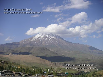
Damavand View From Polour Village
5671m
Damavand
Summit of Iran
Summit of Middle East
Highest Volcano in Asia and Europe
Second Highest Volcano in The North Hemisphere

More in MDG
Mt damavand difficulty, toughness, and climbing grade, wintwer ascend tour, summer hiking and trekking, tips and tricks, damavand tour 2010, photo and video, volcanic activity, weather, winter climb, world heritage, ski, skitour, news, faq, route map, volcano damavand.

Facts And Figuers MDG880125D
Copyright © Mount Damavand Guide . All rights reserved.

Weather


Weather Forecast
Mount Damavand and other Iran mountain and city Weather Forecast.

Mount Damavand 5671 m Mazandaran, Iran
6 Day Weather Forecast by Snow Forecast it is about 80% correct .
Top at 5671 m altitude Summit
Mid at 4909 m altitude mid way to the peak
Bot at 4147 m altitude Camp 3 Bargah Sevom

Mt Tochal 3970 Tehran, Iran
Mount Tochal 6 Day Forecast by Snow Forecast is about 80% correct .
Top at 3900 m Tele Cabin Tochal 7th station-Ski pist-Hotel Tochal.
Mid at 2836 m altitude Tele Cabin Tochal 5th station-Old ski pist.
Bot at 1771 m Tele Cabin Tochal 1St station Velenjak, Tehran, Iran.

Ab Ali, Iran
6 Day Weather Forecast for Ab Ali at 2649 m

Darbandsar, Iran
6 Day Weather Forecast for Darbandsar at 3049 m

Dizin, Iran
Weather Forecast for Dizin at 3599 m

Pooladkaf Ski Resort, Iran
Weather Forecast for Pooladkaf Ski Resort at 3231 m

Sepidan Ski Resort, Iran
Forecast for Sepidan Ski Resort at 2655 m

Shemshak, Iran
Forecast for Shemshak at 3049 m

Weather forecast for other Iranian cities:
Interactive Global Geostationary Weather Satellite Images


Yahoo Weather Forecast : Tehran


BBC Weather forecast: Tehran, Iran


AccuWeather Forecast: Tehran, Iran


Winter View Mount Damavand
Mount Damavand Iran, Photo by A.Soltani
View From Haraz Road, Polour Village

Climate
Mt Damavand Climate
Generally speaking Mt Damavand has only two seasons! Summer and winter, the spring and autumn are too short and of minor significance in this topic, it is essential to learn the general Weather conditions prevailing in the area over a long period before your ascend. Regardless of the season, you need a good weather for a successful climb, allways reserve a day in your itinerary for bad weather.

Spring May
Climbing is difficult however Mt Damavand nature is imaginary in spring specially for its beautiful natural red poppy fields which start blooming beigining of May in low parts and gratually covers the upper parts. May and June are best months for hiking & trekking Damavand nature.

Summer June, July, August
Mt Damavand is a popular mountaineering peak for summer, June, July and August are the best and recommended climbing months for Mount Damavand. During these three months, Damavand footpaths are usually free of snow, the weather is relatively mild, access by public transportation to base camp is easy, but the mountain shelters are crowded. Climbers are strongly advised to tackle Damavnd during this climbing season only.
Remember, Damavand weather is fine mostly in summer, but it could change in a short time, and the temperatures may drop to far below zero, so have sufficient cloths with you even during a good weather.

Autumn September
Usually cold and windy, and no water in the area, the shelters are not crowded, you are advised to have winter equipment with you. Due to icy footpath ascend and descend is graded difficult.

Winter October, December, January, February, March, April.

The winter condition may begin from October and last to April, climbing to the Damavand summit is highly dangerous, due to excessive wind and severe weather conditions, snow, ice and other risks, Damavand ascend and descend is graded very difficult. Mount Damavand south route is the best side in winter, either for climbing or ski mountaineering.
Due to vicinity of Caspian Sea, there is heavy snow falls in winter. The season for ski mountaineering is from December to mid May, Best timing for ski tours generally is March & April.
In winter you need a high skilled experienced guide, cars can not go up to the base camp and it is not possible to use mules in the area, so you should carry all equipments yourself.
In winter, Damavand camps need some cleaning from snow and garbage if you are luckky enough to find them under snow! To be successful in winter, you should be very experienced and well-equipped, you need a good timing and good weather.

Warning
Remember the Weather in Mt Damavand could change to disastrous in winter, with strong winds above 100km/h and freezing temprature below -60°C, you must be well-experienced for such a difficult climb or ski mountaineering expeditions in harsh climate in Mt Damavand, and further more remember that rescue and medical facilities are not available in case of injury and emergency, so extra care should be taken for climbing and ski in Mt Damavand in winter and it is done by your own risk.
The weather on Mount Damavand arguably has caused more deaths than any other factor besides bad judgment by climbers. Some climbers appear to rely on weather forecast reports or none at all, but one should note they are forecasts too, and one day their forecast will probably be wrong too.

More in MDG
Weather forecast and meto for iran mt damavand, mt tochal tehran, mt alam, mt dena yasuj, alborz mountain range, zagros mountains, ab ali teran, darbandsar karaj, dizin, pooladkaf shiraz, sepidan yasuj, shemshak, kajereh, damavand iran tour 2010, climbing map, google earth iran, hiking and trekking, photo, iran photo, tour iran.

Weather MDG880125A
Copyright © Mount Damavand Guide . All rights reserved.

Warning


Warnings
Warning for climbing Mt Damavand in spring climate
Spring 2009 May and early June
- 15 May 2009
Due to heavy spring snow fall in the mountain in spring 2009, most parts of the routes are covered by snow and ice and climbing to the summit is very difficult in May and early June.
So for a safe and successful climb in this season:
- You should be very experinced climber.
- well equipped with winter gears.
- crampon and ice axe are necessary.
- you need a good weather.
- well supported .
- ready for any risky and unexpected condition in Mt Damavand.

Warning 1 - to Foreign Climbers
Please be advised it is not recommended to use any unidentified place as your resting place either in the mountain or in the city-villages near the mountain. The safest , the cheapest , and the best resting place for you are Iranian Mountaineering Federation Camps . If you need a reliable and trusty resting place when you travel from Tehran to Mt.Damavand I recommend you to use these camps ONLY :
1- Iran Mountain Federation Camp 1 Polour in polour village near Haraz Road .
2- Iran Mountain Federation Camp 3 Bargah , you can use shelter , tent or whatever you like with no problem.
- Remember Camp 2 Base , known as Goosfand Sara Camp , is not suitable for use in summer , because it is too crowded and too dirty . Some local guy may come to you and invite you to local home as guest house or resting places, you better refuse their invitation .

Warning 2 - to Foreign climbers
Iran Mount Climbing Federation asks all foreign climbers who use south face route to pay 50 USD per person as permit fee to its representative and take a ticket. Please do not try to cheat the permit fee by going other ways and by-passing the unusual route because, unfortunately, the representive is impolite and may try to take the fee by immoral ways. On behalf of Iranian Mountain Climbing Society, we are very sorry and ashamed of this kind of catchpoll and we condemn such behaver to foreign climbers by Iran Mount Climbing Federation . What a shame!!

Warning 3- to All Climbers
Mount Damavand weather looks good most of the time in summer , but it could change very rapidly and you may not have enough time or energy to find a suitable shelter. So please have sufficient cloths and equipments with you even during a good weather to save your life in case of emergency .
Unfortunately 2 Iranian climbers lost their lives this summer ( 2007 ) because of this unpredictable weather.

Warning 4 - For Winter Climb and Ski Mountaineering
Remember weather condition in Mt Damavand could change to disastrous in winter, with strong winds up to 100km/h and freezing temprature reaching -60°C in the summit , you must be well-equipped and well-experienced for such a difficult mountain climb and ski mountaineering expeditions and harsh climate in Mt Damavand, and further more remember that rescue and medical facilities are not available in the area and in case of injury and emergency you need a good luck for surviving, so extra care should be taken for climbing and ski mountaineering in winter and it is done by your own risk.


Mount Damavand Photo Gallery

More in MDG
Hiking & Trekking and climbing tour Mt Damavand, Iran nature, ecosystem and other Iran mountains. Equipment , gps waypoint , route and trail map damavand . Itinerary , guided tour for Mt Damavand, Iran nature and ecosystem, high skilled experienced guide, services, transport and ski Mount Damavand. Permit, climbing tour, winter climb and ski mt damavand.

Warning MDG880124Y
Copyright © Mount Damavand Guide . All rights reserved.

Volcano


Volcano Damavand Iran
Located approximately 50 kilometers northeast of Tehran, Mt. Damavand is an impressive stratovolcano that reaches 5,670 meters (18,598 feet) in elevation. Part of the Alborz Mountain Range that borders the Caspian Sea to the north, Damavand is a young volcano that has formed mostly during the Holocene Epoch (over approximately the last 10,000 years). The western flank of the volcano includes solidified lava flows with flow levees—“walls” formed as the side edges of flowing lava cooled rapidly, forming a chute that channeled the hotter, interior lava. Two such flows with well-defined levees are highlighted by snow on the mountainside.
Damavand is the highest peak in Iran and the highest volcano in the Middle East. The mountain and its surrounding areas are popular hiking, climbing, and skiing destinations. While no historic eruptions of the volcano are recorded, hot springs on the flanks of the volcano and fumaroles (steam vents) in the summit crater suggest that a hot or cooling magma body is still present beneath the volcano. This continuing activity, while minor, indicates a dormant rather than extinct volcano.

Damavand Volcano Iran
Volcano Damavand Iran

ISS010-E-13393
was acquired January 15, 2005 with a Kodak 760C digital camera with a 400 mm lens, and is provided by the ISS Crew Earth Observations experiment and the Image Science & Analysis Group, Johnson Space Center. The
International Space Station Program supports the laboratory to help astronauts take pictures of Earth that will be of the greatest value to scientists and the public, and to make those images freely available on the Internet. Additional images taken by astronauts and cosmonauts can be viewed at the NASA/JSC
Gateway to Astronaut Photography of Earth.
Earth Observatory

Volcano Damavand, Iran
ERUPTIVE HISTORY
Location: 35.951�N , 52.109�E
Elevation: 18,602 feet (5670 m)
Its 5671-m summit is the highest point in the Middle East.
Damavand volcano towers dramatically 50 km to the NE above Iran's capital city of Tehran. The 5670-m-high stratovolcano is the highest volcano in the Middle East and was constructed above the southern rim of a 9-km-wide caldera.
The well-preserved summit crater of the trachyandesite-to-trachytic volcano contains a small lake, and young lava flows from summit and flank vents cover the western side of the volcano. The earliest lava flows are thought to post-date roughly 38,500 year old terraces. The absence of Pleistocene glacial erosion suggests that the main stage of edifice construction occurred during the Holocene (Catalog of Active Volcanoes of the World). No historical eruptions are known, but hot springs are located on the volcano's flanks, and fumaroles are found at the summit crater. (Description courtesy of the SI/USGS Global Volcanism Program)
The natural beauty of Mt. Damavand
A dormant volcano with a narrow summit. Location Alborz Mountains, Iran. Height 5671. First climbed W.T Thomson, 1837. The seasoned traveler in Iran is so used to seeing gaunt, rugged precipice , jagged peaks and bare deserts, that the sight of Damavand is a relief and surprise to the eye. Visible From many kilometers away, thought it is surrounded on every side by the peaks and ridges of the albroz, its superior height and singular outline compel attention. It is not surprising that such a prominent mountain should figure in the national epic of Iran.
An image from the Iranian Epic of Shahnama Photo courtesy of Answers.com. For more information on Shahnama, click HERE Written around 1000AD, the great Iranian poet, Ferdowsi Tousi, relates in his epic �Shahnama� how the tyrant Zohak is overthrown by the young Feridun and imprisoned in chains to die in a cavern on the slops of Damavand. Local legend asserts that his groans may still be heard on this slopes.For more information on Mt. Damavand, Summitpost.org has an amazing array of photographs, trip reports, links and climber summit logs available HERE.
Volcano.und.edu
Astronaut photograph


Volcano Damavand Iran

Tour Mt Damavand, Iran nature, ecosystem and other Iran mountains. Equipment , gps waypoint , route and trail, itinerary, guided tour, iran nature and ecosystem, high skilled experienced guide, services, transport and ski mount damavand, permit, climbing tour, winter climb and ski.

Volcano Damavand MDG880124X
Copyright © Mount Damavand Guide . All rights reserved.

Video


Mount Damavand Video Clips
Please wait few seconds for the player to load the video clips.
To download the videos click on the links. We will update the album frequently.


Celebration on Mt Damavand Summit 19 June 2007
Sherpa and Toni Gosztoni, very interesting , I like it.
Download Video


Volcanic Activity of Mt Damavand 19 June 2007
Download Video

More in MDG
Hiking trekking and climbing tour damavand, iran nature, ecosystem and other Iran mountains, equipment, gps waypoint, route and trail map, itinerary, guided tour, Iran nature and ecosystem, high skilled experienced guide, services, transfer and ski iran, permit, climbing tour, winter climb and ski mt damavand.

Video Clips MDG880124T
Copyright © Mount Damavand Guide . All rights reserved.

Tour


Mount Damavand Tour
Many of you may have dreamed of standing on the roof of Iran and peak of Middle East, we give you this opportunity to try your dream and truly experience the magic of this beautiful volcano, keep in touch for more information, and let's work together to finalize all tour arrangements.

We have regular private custom designed tour for Mt Damavand and other Iran mountains and we take many Iranian and foreign groups and individual to the summit each year .
Do not forget to book your tour with us in advance to get the benefit of our most experinced guides.

We offer these kind of Mount Damavand Tours:

1- Private Damavand Tour
In this private pakage we provide the best exclusive custom designed tours for you.

Demavand Private Tours
Mount Damawand Private Tours

2- Share Damavand Tour
Economy shaed tour to reduce your costs. We start with a single clients signe up, and welcome others to join the tour , minimum to start the tour is based on 4 persons, Interested parties will be in touch for details.

Mt. Damawand Shared Tours
Mount Demavand Shared Tours


Mount Damawand Guide Photo Gallery

More in MDG:
Hiking & trekking, winter climb and ski guided tour, facts and figures, permit and price iran, equipment list, gps waypoint, google earth, photo, camps, route and trail map, summite, icefall, glacier, high skilled guide, weather iran, tour news 2010, Hiking & Trekking Iran mountains, nature, ecosystem, guided tours, winter climbing and ski mountaineering tour iran.

Tour MDG880124S
Copyright © Mount Damavand Guide . All rights reserved.

Sickness


Mountain Sickness

Introduction

A family of related medical conditions that sometimes develop when people travel to altitudes above 3500m (11,500ft), at times even lower. There is a wide variation in both the speed of onset, the severity of symptoms and also at the height at which they occur – this is different for each person. The problems are caused by lack of oxygen.

Acute Mountain Sickness
Most people feel at least a little unwell if they drive, fly or travel by train from sea level to 3500m. Headache, fatigue, undue breathlessness on exertion, the sensation of the heart beating forcibly, loss of appetite, nausea, vomiting, dizziness, difficulty sleeping and irregular breathing during sleep are the common complaints. These are symptoms of Acute Mountain Sickness (AMS), which usually develop during the first 36 hours at altitude and not immediately on arrival. Well over 50% of travellers develop some form of AMS at 3500m, but almost all do so if they ascend rapidly to 5000m (16,400ft).

Acclimatisation
Usually, these unpleasant effects of lack of oxygen wear off over two to three days, particularly if no further ascent is made. Once the body has acclimatised in this way, further gradual height gain is possible although symptoms may recur at any time. The question "How high, how fast?" has no absolute answer because of individual variation, but it is reasonable for healthy people of any age to travel rapidly to 3500m, though many will develop some degree of AMS after arrival. It is unwise to travel much above 3500m immediately from sea level.
Above 3500m, the speed of further height gain should be gradual and we advise no more than a 300m increase in sleeping altitude per day (with a rest day every third day) and spending at least a week above 3500m before sleeping at 5000m. This does not mean you can’t ascend more than 300m in a day (eg. to cross a pass or attempt a summit), as long as you descend again before sleeping. The highest altitude where man lives permanently is about 5500m (18,000ft) but on mountaineering expeditions or a trek, residence for several weeks around 6000m (20,000ft) is quite possible and at these altitudes one should feel entirely well when acclimatised, being limited only by breathlessness on exertion.

Prediction of AMS
There is unfortunately no way of predicting whom AMS will seriously trouble and who will escape it. It is tempting to suppose that being physically fit and avoiding smoking would help in prevention but unfortunately, this does not seem to be the case. Similarly, if you have previously been affected (or not), it seems no more or less likely that you will avoid AMS the next time you travel to altitude.
Strenuous exercise at altitude, whether or not the subject is fit, makes AMS worse; undue exertion and heavy loads should therefore be avoided until acclimatised. Patients with heart or lung disease or high blood pressure should seek specialist advice before travelling above 4000m.

Prevention of AMS: Diamox (acetazolamide
There has been much research on Diamox, a drug used to reduce fluid retention (it makes you urinate). There is no doubt that Diamox is genuinely useful in the prevention of Acute Mountain Sickness if taken for several days before ascent, however it is not without it’s dangers. If people really want to take this as a prophylactic medication, I usually give 125mg Diamox twice daily for 3 days before ascent to 3500m (or more), and for two more days - i.e.
five days in all. Exactly how it works is unknown, but its effect on breathing (it makes breathing faster and deeper in sleep) may be more important than its direct effect on the output of urine.
Travellers who choose to take Diamox should be aware of its unwanted effects - for all drugs have their dangers. Some people feel nauseated and generally unwell, and tingling of the fingers is quite common. More unusual side effects include flushing, rashes, thirst, drowsiness or undue excitement, and occasional serious allergic reactions - although these cease when the drug is stopped. A test day (or two) of Diamox at sea level well before a trip is sometimes helpful.
It should be noted that Diamox is not recommended as a routine drug before any ascent: many mountaineers and trekkers prefer to do without it (I do not usually take it myself). The important point to understand is that it only relieves the symptoms of AMS and will not prevent the condition worsening should a sufferer fail to descend or rest. Thus its routine use to before, or to allow continued or rapid ascent is extremely dangerous, possibly masking warning signs (symptoms) of more serious HAPE and HACE and allowing ascent to a point where subsequent descent is difficult or impossible. Diamox should only be used for the relief of AMS in a controlled fashion, to allow descent and rest - the only cure for AMS.

Prevention of AMS: Hypoxic Training
Over the years there have been various attempts to train in a hypoxic environment – other than going high, which is obviously the simplest advice. Recently, a hypoxic tent has been marketed in the US, however we have no information about the efficiency, safety or cost of the system, and would welcome information from anyone who has used it.

Treatment of AMS
It is important to emphasise that Acute Mountain Sickness, though unpleasant, is usually a self-limiting condition without serious long-term consequences. Aspirin, Panadol (paracetamol), or Neurofen help the headache, and drugs used for travel sickness such as Avomine (promethazine), Stemetil (prochlorperazine) and Stugeron (cinnarizine) may help the nausea and dizziness. Dexamethasone (a steroid) is also used. Oxygen by mask also helps the symptoms, as does use of a portable altitude compression (PAC) chamber.
Personally, I tend to use no drugs (apart from oxygen) unless really necessary because the symptoms usually resolve: the only cure is to rest, become acclimatised to the lack of oxygen and if necessary descend. The most important treatment is not to go higher if one has symptoms and to consider losing altitude if either recovery does not take place within several days - and certainly, if symptoms become steadily worse.

Severe Forms of AMS: High Altitude Pulmonary and Cerebral Edema (HAPE & HACE
In less than 2% of travellers AMS occurs in several serious forms at 4000-5000m and occasionally lower. High Altitude Pulmonary Oedema is one, in which fluid accumulates in the lungs and causes severe illness (which may come on in minutes) recognised by breathlessness and sometimes a bubbling sound in the chest.
Early pulmonary oedema should be suspected if breathlessness at rest occurs or if someone has what appears to be a persistent cough or chest infection causing breathlessness. Patients with pulmonary edema are dangerously ill and should be treated as an emergency and evacuated to a lower altitude. Frequently a descent of only 500m is sufficient to improve the situation dramatically. Oxygen by mask is especially helpful, as are PAC chambers, Nifedipine, Diamox and steroid drugs (see below).
High Altitude Cerebral Edema is another form of AMS, thankfully also a relative rarity. It is due to fluid collecting within the brain causing the victim to become irrational, drowsy and confused over a period of hours - their walking will become unsteady and double vision, headaches and vomiting may occur. Again, the condition is a serious one and evacuation to low altitudes mandatory. Steroid drugs such as Dexamethasone (Decadron) are used in treatment, in addition to oxygen and/or a PAC chamber.
In both these conditions, medical advice is desirable though it may well not be available. Anyone suspected of having pulmonary or cerebral oedema should be evacuated to lower altitude promptly and should certainly not go high again until a doctor has seen them. Complete recovery from both conditions is usual if the casualty is treated early and appropriately.

Peripheral Oedema & Retinal Haemorrhages
Fluid retention causing swelling of the face, an arm or a leg is sometimes noticed on waking or after a long march - this is peripheral oedema. The condition usually subsides over several days and does not herald pulmonary or cerebral oedema. Haemorrhages into the retina (minute blood blisters in the back of the eye) are known to occur quite commonly around 5000m but very rarely cause any problems, being unnoticed by the subject and visible only to a trained observer with specialist equipment (an ophthalmoscope). Very occasionally, these tiny haemorrhages interfere with vision (causing a "hole in the vision") – if affected descent is advised, and complete recovery is usual though not invariable.

Summary
Acute Mountain Sickness is a common and minor, though debilitating problem at high altitude. Rarely, it leads to two potentially fatal conditions – High Altitude Pulmonary and Cerebral Oedema (HAPE & HACE) - both of which are medical emergencies.
In giving advice about travel to high altitudes it must be stressed that the simple adage of gaining height slowly and descending promptly if one is ill - advice known for generations in all high countries - cannot be bettered. More detailed notes about treatment of all forms of AMS follow.

TREATMENT OF AMS, PULMONARY AND CEREBRAL OEDEMA

Mild AMS
1. Rest days, relaxation, descent?
2. Aspirin, paracetamol, Neurofen
3. Drugs for nausea & vomiting (see text - they are often unhelpful)
4. Oxygen by mask, PAC chamber


Severe AMS/High Altitude Cerebral Oedema

1. Descent, evacuation, oxygen by mask
2. Dexamethasone 8 mg by mouth followed by 4 mg every 6 hours for 24 hours
3. PAC chamber
4. Diamox (acetazolamide) 125-250mg twice daily for 3 days

High Altitude Pulmonary Oedema
1. Descent, evacuation, oxygen
2. Nifedipine 20 mg by mouth + 20 mg every 6 hours for 24 hours
3. Pressure bag

Severe Altitude Illness, type unknown
No harm is likely if all treatments are given:
1. Descent, evacuation, oxygen
2. Dexamethasone as above
3. Nifedipine as above
4. Pressure bag

NOTE: The potential unwanted side effects of the drugs mentioned above (listed above and in sheet 3) should be considered before their use.

The UIAA Mountain Medicine Centre is supported by:
Mount Everest Foundation
Foundation of Sport and the Arts
British Mountaineering Council
International Union of Alpine Associations (UIAA)
Dr Charles Clarke FRCP
Updated October 2002
© UIAA Mountain Medicine Centre


Mount Damavand Photo Gallery

More Topics
Climbing and ski mountaineering Mt Damavand. Hiking & Trekking, Iran mountains, nature, ecosystem . Guided tours , winter climbing tour Mt Damavand .

Mountain Sickness MDG880124C
Copyright © Mount Damavand Guide . All rights reserved.

Best Mount Damavand Climbing Experience with Local Guides

  Best Trekking & Ski Youring Guides in Mount Damavand’s Adventure The Role of Certified Guides in Mount Damavand’s Unique Adventure. Th...