21 January 2011

damavand-tip


Common Mistakes Part2
21 Jan 2011, Posted by MDG.

In this topic you can find some other reasons which are the main cause of unsuccessful attempts to Damavand summit and our suggested ways to increase your chance of success to the peak.
If you have the feeling of exhaustion, weakness, lack of energy and disorientation to go ahead and continue the ascend, the followings could be the main cause of your problem. To overcome this and for adaptation to the new environment, just before atempting the mountain, we suggest to a have a good rest after your flight. Camp1 Polour ans Camp3 New Hut are ideal places for your rest and accomodation. Read more in part1.

Damavand mountain
Damavand Iran, Photo by A. Soltani

Jet Lag
After a long flight or a long journey across different time zones, jet lag is a cause of being exhausted and excessive tiredness. If you are coming from a country with more than 3 hours difference in time zones, you may need one extra day rest for adaptation to the new environment.

Biological Clock
The natural mechanism that controls the cyclical physiological activities of organisms.
You may ask yourself, "what time is it by your internal biological clock ?!" The answer is, "it take some time that a person can biologically perform a certain function."
It is not recommended to do tough exercises while your internal biological clock indicates that the body is in the resting mode, it is quite wrong to attempt climbing when the biological clock of your body says it is sleeping time!

Biorhythms
Sometimes there could be more factors that you feel you are not in a good mood for climbing, factor such as biorhythm cycles. Biorhythm is an attempt to predict various aspects of a person's life through simple mathematical cycles, your life is affected by rhythmic biological cycles which affect your ability in various domains, such as physical, mental, and emotional activity. These cycles begin at birth and continue throughout life; thus, by modeling them mathematically, a person's level of ability can be predicted from day to day.


Mount Damavand Photo Gallery

More in MDG
Damavand Ski and snowboard, tour 2011 tehran winter sport, moun expedition tour, tour organizer, damawand climb, trek, hike, mountaineering, tour guide 2011, iran ski federation resorts, iran photo, picture, image, guided tour, mountain guide iran, beautifull villages near damawan, climate in the mountain, formation of volcano, magma plates, lava material , volcano fact, interesting facts, what type of mountain is demavand? is it a volcano?, volcano information, sattelite images of mount, physical map, south face route, demavan peak pictures, climbing mount damavend in april.

How far can you see from the top of damavend, national park, ski down mount damawand, damawan peak information, iran demavand new hut booking, how was a mount formed, skiouring, iran, damávand tour, altitude sickness, travel from ararat in turkey to iran, maps of the danger zones in iran, image of iran skiing in winter, trekking iran summer 2011, ascent to sabalan iran, grass ski alborz mountains, make a nose guard for ski and mountaineering, ski of iran mountain, highest ski resort, snow situation 2011 dizin, iran mountain climbing federation, avalanche danger, zagros ski mountaineering.

Avalanche transceiver tehran, which hand held gps for ski 2011, alborz mountains resorts, winter 2011 conditions, snow conditions at shemshak, ski touring zagros, elborz mountains hiking, alborz mount elevation, top digital gps for mountaineering, iran caravan, caravansara, caravan sara, caravanshra, caravan shra, at what height to take diamox, summit tempreture mountain, what is the best time to climb damavand, damawand volcan most recent eruption, most resent eruption of volcano, demavand volcano amazing and interesting facts, climate and weather weather forecast damavand.

Common Mistakes Part2 MDG21JAN11
Copyright © Mount Damavand Guide . All rights reserved.

05 January 2011

Dizin-GPS-Track


GPS Track 4
Tehran to Dizin Road Map, GPS Track & Waypoints.
Useful for Ski, Grass Ski, Snowboard and Mountaineering.
5 January 2011, Posted by Sherppa.

Dizin is the the most famous ski resort, the largest piste and the best winter sport center of Iran. Located near Chalous Road in the north west of Tehran in Alborz Mountain Range, it is also the famous grass-ski centre for summer sport activities. This resort is the best place for parctice and acclimatization for skiers before trying the giant Damavand peak.
Targeted Activities: Skiing, Snowboarding, Grass Ski
Read more info for Disin Resort.


Google Map Tehran to Dizin Ski Resort
Map by MDG

Geographical Location and Coordinate
Dizin
Base Altitude: 265m - 3600m
Latitude: 36-02-57 N (36.050316 N)
Longitude: 51-25-02 E (51.417953 E)

Tehran Starting Point:
(Tehran, Resalat Highway, Mosala Metro Station).
Latitude: 35-44-25 N
Longitude: 51-25-35 E

Download
Tehran to Dizin Road Map & GPS Track File
(by Garmin Oregon 550 Navigator)

Dizin Ski Resort Map in JPG Format: Download
Print friendly Google Earth Road Map.

GPS Track in GPX Format: Download
Useful for most handheld GPS receivers.

GPS Track in KMZ Format: Download
Useful for Google Earth.

Quick Facts
Tehran to Dizin by Car
Distance ( Cartographic Length ): 126 km
Average Speed: 45 km/h
Maximum Speed: 120 Km/h
Total Time: 02:45

How to go to Disin
The only access to the resort is by road. You may reach the area by two differnt road, the first one is longer but a safer way.

Via Chalus (Chaloos) Road 126 km
1- Tehran> (Resalat Highway, Mosala Metro Station)> Tehran-Karaj Highway> Chalous Road> Dizin junction> Dizin Resort.
Or
Via Shemsak Road about 55 km
2- Tehran> (Resalat Highway Baqeri Junction)> Tehranpars 4th Sq.> Gardaneh Ghochak> Lavasanat> Oshoun Fasham Road> Shemshak City> Dizin Resort.

Winter Warning
- Dizin is only accessible by road, after a heavy snowfall, snow chains are necessary for cars.
- The road between Shemshak and Dizin which is about 12 km long may be closed in winter after a heavt snow due to avalanch risk.
- In bad weather and stormy condition, bad visibility or darkness, it is not safe to ski without a reliable navigation unit like a handheld GPS receiver.

Related Topics:
GPS Tracks for Mt Damavand Iran.
GPS Tracks for Shemshak Ski Resort.

Dizin Ski Resort GPS Map
Google Map Tehran to Dizin Ski Resort

More in MDG
Ski and snowboard resorts for winter sports iran, transport from ika international airport tehran to dizin resort, tour 2011 damavand summit iran, tehran to disin GPS track and google earth map, peak coordinates, landmark, detailed ski resort information, grass ski tour guide, trek mountain expedition, tour, travel tour organizer, 4wd expedition, nature society tehran, trekking iran in winter, price for climbing iran mounts, natural national heritage site, skiing tochal area, damavand climb, tek, hike, mountaineering, tour guide 2011, iran ski federation resorts.

Mountain photo, picture, snapshot, image, photography, photographic, digital photos, images of nature, iranian winter, the east route of the volcano, the north face of the mountain, nandal, the south face of the sumiit, mount guided tour, mountaineering guides in iran, facts, maps, reyneh iran hot springs, iranian persian hiking groups, buying mountain clothes in tehran, piste koohrang, distance from tehran, interesting facts, climbing alborz mountain zone, tochal safety info, elborz mountain trek/skiing in winter 2011, cave ali sadr, google map, zagros ski mountaineering, travel from ararat in turkey to damavand iran, ski weather forecast tehran.

Dizin GPS track MDG05JAN11
Copyright © Mount Damavand Guide . All rights reserved.

01 January 2011

Shemshak-GPS-Track


Happy New Year!

GPS Track 3
Tehran to Shemshak Road Map, GPS Track & Waypoints.
Useful for Ski Mountaineering and Snowboarding.
1 January 2011, Posted by Sherppa

Shemshak ski resort is located in the middle of Alborz Mountains Iran, it is one of the best down hill track for wild ski mountaineering and freestyle snowboarding. It has excellent powder snowfall in winter, a suitable place for advanced skier and snowboard lovers before trying Damavand. It is the second largest piste in Iran after Dizin resort.
Targeted Activities: Cross-country Skiing, Ski, Snowboard.

Read more info for Shemshak Resort


Google Map Shemshak Ski Resort Tehran, Iran
Map by MDG

Geographical Location
Shemshak
Altitude: 2530m - 3050m
Latitude: 36-00-33 N (36.009192 N)
Longitude: 51-29-36 E (51.493492 E)

Tehran Starting Point:
(Tehran, Resalat Highway, Baqeri Junction, Baqeri Metro Station).
Latitude: 35-43-57 N
Longitude: 51-31-3 E

Download
Tehran to Shemshak Road Map & GPS Track File
(by Garmin Oregon 550 Navigator)

Shemshak Ski Resort Map in JPG Format: Download
Print friendly Google Earth Road Map.

GPS Track in GPX Format: Download
Useful for most handheld GPS receivers.

GPS Track in KMZ Format: Download
Useful for Google Earth.

Quick Facts
Tehran to Shemshak by Car
Distance ( Cartographic Length ): 43 km
Average Speed: 32 km/h
Maximum Speed: 90 km/h
Total Time: 01:30

How to go to Shemshak
You may reach the area by three differnt roads, the first one is shorter and a preferred way.
1- Tehran> (Resalat Highway Baqeri Junction)> Tehranpars 4th Sq.> Gardaneh Ghochak> Lavasanat> Oshoun Fasham Road> Shemshak.
2- Tehran, Afsarieh Highway> Yasini Highway> Telov Road> Lavasanat> Oshoun Fasham Road> Shemshak City.
3- Tehran-Karaj Highway> Chalous Road> Dizin junction> Dizin Resort> Shemshak Road> Shemshak Resort.

Winter Warning
- Shemshak City is only accessible by road, after a heavy snowfall, snow chains are necessary for cars.
- The road between Shemshak and Dizin which is about 12 km long is usually closed due to avalanch risk.
- In bad weather and stormy condition, bad visibility or darkness, it is not safe to ski without a reliable navigation unit like a handheld GPS receiver.

Related Topics:
GPS Tracks for Mt Damavand Iran.
GPS Tracks for Dizin Ski Resort.

Shemshak Ski Resort GPS Map
Google Map Tehran to Shemshak Ski Resort

More in MDG
Mountaineering damavand iran, tehran to shemshak GPS track and climbing map, gps coordinates, peak waypoint and landmark, google map, google earth, winter climbs and mountaineering tour 2011, garmin gps navigator, GPS tracking system, skiing season in dizin and shemshak resorts, ski tour guide and touring, mount guide, expedition, mount weather forecast, damavand tour 2011, skipiste, adventure tour info, trekking and climbing tours, travel gps map, ski tour 2011, iran natural attraction tours, tour organizer, volcano activity demavand, rivers and lakes in iran, where is mount damavand iran, off piste skiing, downhill skiing, cross country skiing, snowboarding, people, snow sports, iran winter sport.

Resort shemshak in alborz mountains, planet images, photography, images and photo iran, most recent eruptions, skiing in winter, ski season, domavand montain in iran, damawand messner, winter climb demawand, damawand koh, bargahe sevom, damavend skitouring, skitour dizin and darbandsar, climbing mount damawand permit, americans mt demavand, dizin cottage, damavend winter climb, damawand sherppa, iran damawand weather, photo, picture, snapshot, image produced by photographic for mount in iran, permission required to climb mount demavand iran, first person to climb mt. damavend, garmin map, climb mt. damawand, tehran demavand distance, best season climbing mt damavand.

Shemshak GPS track MDG01JAN11
Copyright © Mount Damavand Guide . All rights reserved.

27 November 2010

Damavand-GPS-Track


GPS Track 2
Useful for Mountaineering, Ski and Snowboard
27 November 2010 Posted by Sherppa

There is a descend (return) route on the south face of Damavand Mountain called Shen Ski (soft type of soil), it is a comfortable way to go down especially for tierd mountaineers who return from a tough climb, also it is the best down hill track for wild ski mountaineering and freestyle snowboarding.

This descend route is located between Damavand summit 5671m and the Camp3 New Hut 4250m, the covered area has a mild climbing slope without rocks and guideposts, it is the easiest return way of the mountain, in good visibility you can find your way back easily.

This GPS track file is ideal for:
A- Descend in Summer
Climbers who have summited successfully and prefer an easier way down to avoid rocky parts, suitable when the valleys are free from ice and snow and the the ground is covered with soft sands.

Please remember this track is slightly different from ascend route and is not recommended for climbing up! It is suitable for descend only. (The green line on the following map shows the ascend track).

B- Ski Mountaineering and Snowboarding in Winter
The best track for Ski Mountaineers and snowboard lovers to enjoy 3000 meters long distance and 1400 meters altitude downhill ski in snow during the winter and go down from the peak to campsite3.

Shen Ski GPS Track File in GPX Format
(Damavand summit to Camp3 New Hut)
by Garmin Oregon 550 Navigator
Download

Warning
In bad weather and stormy situation, poor visibility or darkness, it is not safe to go upper than the fake summit 5400 meters without a reliable navigation unit like a handheld GPS receiver.

Visit Also:
GPS Tracks for Mt Damavand Iran.
GPS Landmarks.

Damavand Mountain GPS Track
GPS Tracks Mt Damavand Itan


South Route GPS Track Damavand
Mt Damavand South Route GPS Track

More in MDG
Damavand iran, how to climb, warning for mountaineering, equipment list, trail and climbing map, gps coordinates, way point to the peak, google map, google earth satellite image, damavand volcano winter climbs and ski mountaineering tour 2011, Garmin Oregon 550 Navigator, GPS satellite tracking system.

Continuous tracking,damavand climbing and ski season iran, dizin and shemshak ski resorts iran, local ski tour guide, ski touring, iran mountain and ski guide, ski expedition, mount tochal ski resort, how to hike in iran, how to get to the mountain, damavand weather forecast.

Damavand expedition tour 2011, ski resort and piste, touring information, adventure tours, hiking trekking, ski tour, climbing tours, travel map, guided tour 2011, sightseeing iran natural attractions, ecosystem tourism, touring organization, travel agency.

GPS Track Files - Descend MDG27NOV10
Copyright © Mount Damavand Guide . All rights reserved.
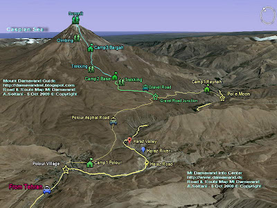
12 October 2010

Damavand-Iran-GPS-Track


GPS Track 1
Useful GPS Track File for Mt Damavand Danger Zone
12 October 2010 Posted by MDG

Danger Zone is an area which is located between the Fake Summit 5400m and the real Peak 5671m on the south face of Damavand. In an ordinerary weather and good visibility it is an easy part of the mountain, but in poor visibility and bad weather it is difficult part of the route.

The area is the most incident part of the mountain which many accidents has happened there, mountaineers lose their way easily when they return down from the summit due to bad visibility, darkness, stormy and violent weather.

GPS Track File in GPX Format
(by Garmin Oregon 550 Navigator)

This GPS track file is very helpful to show you the actual footprints up and down to safly pass through this dangrous zone, it could save your life, take care.

Track File Fake Summit 5400m to Summit 5671m (Danger Zone)
This track file is suitable for ascend and descend.
Download GPS Track

This area looks like a desert, without signs or rocks, it has a mild climbing slope with only few guideposts, you may not find the guideposts in bad visibility, you can ascend easily but you may not find your way back.

Warning
In bad weather, foggy condition and poor visibility, it is highly recommended not to go upper than fake summit without a reliable navigation equipment such as a handheld GPS receiver.

Visit Also:
GPS Tracks for Mt Damavand Iran.
GPS Landmarks.

Damavand Mountain
Danger Zone Damavand Mountain Iran
Photo by A. Soltani

Volcano Damavand
Google Earth Damavand Mountain

More in MDG
Common mistakes damavand volcano, difficulty and climbing grade, gps landmark, waypoint and traks, route and trail map footprints, climbing map, goog earth iran, gps tracking unit, the southern route, handheld gps receiver, how to climb damavand volcano, warning for foreign mountaineers, damavand weather forecast, bad weather fog and cloudy condition, climbing season, winter temperature, freezing temprature, winter climb and ski expedition iran, info avalanche and glacier, weather tehran iran. Damavand winter climb and ski mountaineering tour 2011.

Elborz and zargos mountain ranges, iran ski season, chelgard ski, dizin ski resort iran, local ski tour guide, ski tour damavand mountain, iran mountain ski guide, ski expedition elborz and zagros mountains, mount tochal ski resort, ski tocha, proper gear, difficulty reaching the summit in the winter, falls and avalanches, bad visibility due fog and cloud, fake peak volcano, the real peak, iranian climbers. The recorded location data is stored within our tracking unit at regular intervals using a Garmin Oregon 550 Navigator, Live GPS Tracking, Global Tracking Communication, GPS tracking systems, GPS satellite tracking system.

GPS tracking solutions, All-Weather GPS Tracker, Continuous Tracking, GPS tracking unitdamavand expeditions, avalanch incident in shemshak road, damavand volcano, google map of mount damavand, equipment list for climbing damavand volcano, damavand gps coordinates, route map gps landmark to damavand peak, google earth satellite image, google earth map, gps routing damavand, route up mt damarvand, sabalan gps, where to hike in iran, demavend track on google map, how to get to damavand, google landmark 2 gps, map of mount suleiman in the alborz mountains, haraz road map.

GPS Track Files for Danger Zone MDG12OCT10
Copyright © Mount Damavand Guide . All rights reserved.

08 October 2010

Damavand-Iran

Economy Outlook in Iran
Removal of Subsidies and Uncertain Economic Situation in Iran
8 October 2010 posted by Sherppa

As the international sanctions against Iran being widely imposed and the decision by the government to remove subsidies on many goods such as petroleum products, electricity, water, wheat, milk, rice etc, we are expecting a huge price raise and high inflation rate for the next few months.

The removal of subsidies will cause a great raise in all prices in iran, this will effect most costs for travel and tourism too, including for Mt Damavand climbs and caltural tours in Iranian cities.

Already the government has raised 30% increase for the domestic airline tickets this week and it is expected to announced further new increase to the internal tickets due to annual inflation rate which usually takes effect every year on 21 March (Iranian New Year).

It's not immediately clear how high this new inflation will go, but it may take effect from October 2010 to March 2011.

So kindly be advised due to this uncertain economic situation here, we may not be able to offer you precise costs and prices for some travel services at the moment.

Damavand Mountain
Damavand Mountain Iran, Photo by A. Soltani

More in MDG
Damavand ski & winter climbing tour 2011, hiking & trekking tours 2011, damavand iranian, travel and tourism tours 2011 damawand mountain, eco adventure, holiday tour outdoor activity, visiting desert nature and eco, online encyclopedia for damavend, holiday calendar persia 2011, flag on top of mount, Q&A about damavand iranian peak, women climbing mount damavand, is iran safe to visit and climb mountain damawand, information about trekking and hiking center, information mt. damavand location, homepage alborz mountains.

Damavnad guide com, bus tehran to damavand, dizin cottage, elavation of mt zargos, ganj nameh waterfall hamadan, glacier sunglasses nose guard, gol zard polour, high quality trekking head lamp, hostel polour village, hotel apartemane, persian campsites, iran mountain federation, mountaineering, mount damavand blog, mount damavend rock grade, sabalan cave iran, sherppa of mt damavand iran, smooth thin wool liner socks, takhte-soliman mountain, tang-e chogan bishapur, tchogha zabnil, what is the highest mountain in iran, wool hat with goretex, wool or pile socks, mountaineering foto cameras, best stream drinking water, demawend trip, ab ask - amol ask mineral spring.

Persia mountain federation, highest mountain in europe, the iranian hiking federation, website iranian mountain federation, anjoman kohnavardan, iranmountain association, cottage in dizin, cave iran stalagmites, damavand ski season, chelgard ski, closest international airport to dizin iran, damavand ski guide, local ski tour guide, damawand ski touring, ski tour damavand mountain iran, iranian mountain ski guides, ski mountaineering iran, ski expedition alborz mountains, ski mountaineering and winter climbs damavand, mount tochal ski resort, skiing tochal, mt damavand ski touring, ski iran summer, tehran to dizin ski piste distance.

Mt demavand trekking tour, koh tour damavend tour, hiking damavand mountain, birdwatching and wildlife teheran, damawand travel guide, mountain guide, mountain guides iran, local tour guide, demavend ski touring, hiking tour in damavand mountain iran, iranian mountain guides, trekking alborz mountains, bisotun climb, damawand winter tours, demavend expeditions, tour & travel linksblogspot.com, tourist inn hotel iran, trek alborz mounta, trekking blogspot.com, zagros hiking , zagros mountains climing, google mt.demavand expeditions, damavand trek, visiting the zagros mountains, MDG16OCT10A.

Latest Economic Situation in Iran MDG08OCT10A
Copyright © Mount Damavand Guide . All rights reserved.

18 September 2010

damavand-iran-holiday


Public Holidays
Iranian Public Holidays, Weekends and Damavand Crowds
18 September 2010 posted by MDG

Damavand mountain is well-known for its 5671 meters height, this giant volcano is also a popular peak for its mild climbing slopes and moderate climbing grade. Today, Damavand Iran is an international tourism target and one of the world's finest peaks.

This popularity makes some crowd problem for the mountaineers in summer national public holidays, anniversaries and weekeds. To enjoy your Mt Damavand tour or any kind of caltural trip to Iran and to meet the least possible crowd problem, it is highly recommended to avoid these undesirable holidays. Let us know your itinerary before you book your flight tickets and let's work together to finalize your exact timing.


Tours Damavand Mountain
Base Camp Damavand Mountain Iran
Summer Crowd, Photo by A. Soltani

Disadvantages
Of Iranian weekends and national holidays during summer:)
- Mt Damavand camps, shelters/refuges and huts are very crawded.
- Haraz Road is the only access road to the mountain, usually there is a big traffic jams on this road.

Note:
The peak crowd in climbing season is during the school vacations which last from around 20 June to 23 Sep. The peak of the peak is about 6 August. So consider these days in your itinerary to avoide any kind of problem or unconvinced situation, these days are not suitable for Mt Damavand tour or any kind of travel to Iran.

Summer Tour Mt Damavand Volcano
Near Base Camp Damavand Volcano


Summer Crowds, Photo by Sherppa

Tips
For climbing in summer season and Iranian new year.
- you are advised to avoid climbing in Iranian holidays and weekends.
Note, Iranian weekends are Thursday and Friday.

- It is suggested to start your programme on Saturday to Monday and finish it before the weekend.

- Avoid travel to Iran in new year holidays.
Iranian new year called Nowroz , 21 March to 2 April, the official national holidays start from 20 March, unofficially holidays may be few days more, depending to the long weekends. During this period nothing is in order here, you can not find public transport and the roads are in the worst possible trafic condition and hotels in most cities have no vacancy.

Damavand Mountain Crowded Bargah Sevom Campsite
Damavand Camp3 Bargah Sevom
Crowded Old Shelter, Photo by Sherppa

More in MDG
Damavand mountain ski mountaineering and winter climbing guided tour 2011, hiking & trekking and climbing tours 2011 damavand iran, iran travel and tourism, travel damavand tour 2011, travel mount damovand mountain adventure, summer guided tour from the north face and clasic south route, iran climbing tour, rock climbing & trekking tour, mountain adventure tours, mountaineering & hiking trekking tours for group or individual tourists, ascend iran peak, eco adventure holiday persia, hiking & trekking and walk-up adventure tour iran,tour organization for outdoor activity in persia, visiting damavand mountain, damavand visitor, let's go damavand, mount climbing elborz and zagroz mountains, mount tours iran 2011, trekking mountt tochal to demavand mountain iran, hikking & trekking expeditions 2011 iran, desert and eco nature trekking, climbing expedition, hiking and trekking tours damavand volcano.

Welcom to my fotopages and photo blog, pictures of the explostion travel mount demavand, iran peak wallpaper, free mountains wallpapers and desktop backgrounds,climbing digital picture iran mountain, photo picture damavand iran, climbing photo and video gallery, foto mountain adventure, photo galler center, hiking and trekking pic 2010, landscapes and outdoor recreation photos and pictures, discover damavand iran through pictures and photos,

Information mt. damawand location, difficulty and climbing grade, how to climb, facts and figures, online encyclopedia article on damavand mountain, the extinct volcanic peak of the elburz mountains, damawand mountain is near the southern coast of the caspian sea, because of very high altitude variation in persia, ranging from 28 meters below the sea level up to 5671 meters on damavand volcano, demavand weather meto, météo mount the roof of the middle east, weather iran, news 2010, google earth route map and satellite image damavand peak, weather forecast and snow conditions.

Public Holidays MDG18SEP10A
Copyright © Mount Damavand Guide . All rights reserved.

Best Mount Damavand Climbing Experience with Local Guides

  Best Trekking & Ski Youring Guides in Mount Damavand’s Adventure The Role of Certified Guides in Mount Damavand’s Unique Adventure. Th...