31 January 2010

damavand-danger-zone


Danger Zone
Mt Damavand South Route Danger Zone
There is a dangrous zone on the south face of the mountain causing many death in bad Weather. This deadly area is between the fake summit 5400m and the real peak 5670m, it has been the most accident and casualty part of the southern route and the area where the most losses take place. Some beginner and even few famous Iranian climbers lost thier way and consequently their life in this area.

The area is without rocks, it has a mild slope with easy Difficulty and climbing grade, it is similar to a desert with no sign, there are only few guideposts in the area which you can not find them in fog and cloudy condition. You may consider it as the Bermuda Triangle of this mountain, but without the mysterious and supernatural events, it is a one way road ! you can ascend but you do not find your way back to the Camp 3 New Hut, the climber get lost when they return back from the Summit in this deadly zone.

The major cause of casualty in this area is bad weather and foggy condition, in a good visibility it is easy part of the mountain, in a bad visibility and without any particular Equipment it is possible to climb to the top, but impossile to find any sign, footprints and your way back to descend to the low camps and you may finish with a bitter end.
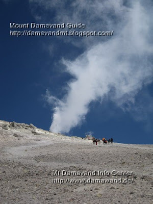
Mt. Damavand South Route Danger Zone
Mt Damavand Danger Zone
Photo by A.Soltani

Warning for Bad Weather
- Do not go upper than fake summit.
- Compass or a gps unit is necessary.
- An experienced mountain guide may be helpful.

GPS LandmarkThe danger zone stars from this point upto the summit, it is also the sulphuric area of the volcano.

Fake Summit
Altitude 5400 m
Latitude 35, 57, 05 N
Longitude 52, 06, 37 E

Fake summit alternate names:
Baam e Jonobi, Sang e Pes-tan, dood koh

Victims of Danger Zone in the recent years

Spring 2009

After their climb to the peak and on their way back, four climbers from Bandar Abas Province, Iran, lost their way to west ridge, three of them died and only thier leader survived.
The Victims:
- Torabi AbdulHamid
- Memari Farkhoundeh
- Keshmiri Sajedeh

Summer 2008
two climbers from Hamedan Province, Iran also after their climb, lost their way to east ridge, near Yakhar Glacers and died.

Spring 2002
Jalal Froozan Rabooki from Tehran, the most famous Iranian climber, lost his way back and had bitter end, his body was found 6 months later in Yakhar Glacers.

Mt. Damavand South Route Danger Zone
Damavand South Route Danger Zone
Photo by Ardeshir Soltani

More in MDG
Common mistakes in mt damavand climbing, difficulty and climbing grade, gps landmark and waypoint, mountaineering, how to climb, route and trail map, sulphur and volcanic activities, weather forecast, bad weather, winter climb, weather warning for foreign climbers, damavand weather, freezing temprature, climate, climbing season, facts, glacier, avalanche, how to climb, logitics for winter climb and ski expedition iran, timing, alert, warning, weather iran tehran, winter temperature, info avalanche and glacier, weather tehran iran, gps landmark, proper gear, wind chill, winter advice, safe retreat, mountain sickness, difficulty and climbing grade in winter, reaching the summit in the winter, info and support, equipment and gear, difficulty factors, disclaimer climbing can kill you, falls, avalanches, climbing map, google earth iran.

Danger Zone MDG31JAN10D
Copyright © Mount Damavand Guide . All rights reserved.

damavand-haraz


Haraz
Haraz is a beautiful mountainous region in central Alborz Mountains in northen Iran, it is located midway capital city Tehran and the Caspian Sea. It attracts a great number of tourists each weekend, due its natural beauties and landscapes, it is well khown for Mt Damavand, Haraz Rivers, Haraz Valley, Haraz Road, Larijan Thermal Springs, Damavand and Ski AbAli Ski Resort, Cave Gol e Zard, Cave Moon and many more mountains, vilages, traditional restaurants and gardens and recreational places.

Haraz poppy fields, Photo by Ardeshir Soltani
Mountain poppy fields in Haraz Area
Photo by Ardeshir Soltani

Mountains
Mt Damavand, the most prominent peak of Iran, the second highest volcano in the northen hemisphere, the highest summit in Middle East and the highest volcano in Asia is located in Haraz Area. The other major mountain in the area is Mount Do Berar (Do Berar means two brothers).

Thermal Springs
There are many minral hot water, spa and thermal springs in this district with particular therapeutic qualities, they are mainly located on the Damavand Volcano's flanks, such as:

- Larijan Thermal Spring, Abe Garm Larijan
- Baeijan Thermal Spring, Abe Garm Baeijan
- Esteleh Sar Thermal Spring, Abe Garm Esteleh Sar
- Ab e Ask Thermal Spring, Abe Garm Abe Ask
( Abe Garm = Hot Water, Thermal Spring )

Haraz Valley, River and Road at base of Damavand, Photo by A. Soltani
Haraz Valley, Haraz River and Haraz Road at base of Mt. Damavand
Photo by A. Soltani

Haraz Road
This road is one of the 4 main roads which connects capital city Tehran to the Caspian Sea in north of Iran, it is a mountain road which passes through Haraz Valley alongside the Haraz River. Usually there is a heavy traffic jam on this narrow main road during Iranain holidays and weekends (Thursday and Friday), so the road is turned to one way direction by police in the peak oftraffice to ease the movement of the vehicles.

Haraz Valley
This valley is one of few to cut through Alborz Mountain Range, it is famous for its natural beauties, it is the longest valley of the Iran, there are many beautiful town and villages in this valley, such as Abali, Polour, Lar Dam Lake, Reyneh Town, Hezar Dasht, Dasht e Mosha, Nava, Vana, Lasem,...the climate of this tourist zone is quite cool in summer, cold and freezing with good snowfall in winter. The charming natural attractions in the area can be reached by car or on foot.

Haraz River
It takes its name from the Haraz region, It flows northward through Haraz Valley in Mazandaran Province, Iran, flowing through Amol city, and ends to the Caspian Sea, it is about 100 km long, the main source of this river is Mount Damavand.

Polour Village in Winter, Polour and Haraz Road, Photo by Ardeshir Soltani
Polour Village Winter View, Polour Haraz Road
Photo: A.Soltani


Road Map Tehran To Caspian Sea

More in MDG
hiking and trekking haraz, climbing expedition tour alborz & zagros mountains, hiking and trekking tour iran 2010, iran nature and ecosystem tour, fauna and flora iran, photo, foto, photo gallery, picture, pic, picture gallery,image, image gallery, video, video gallery, 2010 tour news, landscapes of persia outdoor recreation guide, lar lake, mineral water, damavand iran.google earth, gps, landmark, haraz hiking trekking, iran tourism info, lar lake, mineral hot water.

Haraz MDG31JAN10C
Copyright © Mount Damavand Guide . All rights reserved.

damavand-activity


Volcanic Activity
Volcanic Activity od Volcano Damavand Iran
Located in middle of Alborz Mountains in northern Iran, this young dormant volcano is approximately 400 km3 and is formed mostly during the Holocene geological time, no historical eruption is recorded, the geologists believe that the last eruption goes back to about 10,000 years ago and the the youngest lava flows date back to approx 7000 years ago and no evidence of eruption in the past 1000 year.

This composite cone stratovolcano started some sign of new activty in spring 2007, the hot springs located on the volcano's south flanks become warmer and a big new vent is formed near the summit crater with high fumarolic activity, it releases a great amount of smoke and hot sulphuric gases.

Volcano Damavand Iran
Damavand Volcano Iran
New activity, the red substance are visible
Photo by Ardeshir Soltani

On 19 June 2007, we saw this new changes for the first time, besides sulphur gas and steam, some red material is coming out of the new vent, we are not certain about this red substance, it does not look like lava but it coud be melted sulphur. We believe this new activity worth some study and research.

Climbing Tip
There is no problem for climbing when the wind is in favuor, but if the wind blows against you, it may cause some problem, either on the south or the east route, so when arriving in this smoke zone, modify your track somehow to avoid the sulphur gas.
If you smell and feel too much gas, you can make a simple gas mask by spreading a little vinegar to a handkerchief, it will help you to pass the area, oxygen mask is not compulsory, it is optional.

Volcanic Activity Damavand
To pass the volcanic zone of Damavand you may use a vinegar mask!


This Video Clips showes the new activity of the volcano on 19 June 2007.

Warning
Without sufficient equipment and oxygen mask, it is not safe to go close to the new vent for photography or any other reason, becouse if the wind direction changes, you get caught in the poison gas.

Location and Elevation of South Face Summit
Altitude 5671m - by my personal GPS measurement 5645m
Latitude 35-57-19 N
Longitude 52-06-36 E

Damavand Volcano Iran
Volcano Damavand Iran

More in MDG
Alborz mountain range iran, volcano damavand , volcano formation, historic eruptions of the volcano, beneath the volcano, highest stratovolcano in asia, highest volcano in the middle east, dormant volcano, western side of the volcano,summit vent, magma, ash, new vent, current dormant, emission of sulphur gas and steam 2010, recorded eruption, hot springs, thermal spring, spa.

Flanks, fumaroles, steam vents, summit crater, cooling magma body, continuing activity, dormant, extinct volcano, summit lake, top pool, young lava flow, summit and flank vents, historical eruptions, volcano's flanks, fumaroles, narrow summit, iran nature and eco 2010, popular hiking, climbing, and skiing destinations, nature, ecosystem and iran mountains, gps waypoint, route and trail map, damavand volcano, the natural beauty of iran volcanos.

Volcanic Activity MDG31JAN10B
Copyright © Mount Damavand Guide . All rights reserved.

damavand-contact

Contact Us

Please confirm when you receive our first email reply because we have had problems lately with emails intercepted by spam-filters set too high.

1- Please write Mt Damavand in your email subject, this will help us to quickly distinguish between the real emails and the spams.

2- Be patient, with no exception we will respond to all emails which have mentioned Mt Damavand in the subject.

3- Privacy is our first priority. We never shared your personal info with the 3rd parties because we hate spams as much as you do.

4- To get more accurate reply please reply with the previous correspondence and write your mails in English.

5- If you did not get an auto reply or any answer within 48 hours you may try again, but first look in your spam box.

6- We have answered many questions before, it is a good idea to visit FAQ .

7- If there is any query about climbing or visiting Iran attractions feel free to ask.

8- If you have any recommendation or suggestions about our websites or weblogs, please don't hesitate to drop us a note.

9- Please read Disclaimer.

10- You may see our email address at the bottom of all pages:

Mailto A. Soltani
Solard [at] gmail [dot] com

Contact-us Damavand Info

All Rights Reserved. © 2015 MDG
All the material on our websites and weblogs are protected by copyright. No part of the site may be published, reproduced, stored or transmitted in any form without prior written permission. You may use them for personal use only.

Damavand Mountain
Damavand Mountain Iran
Photo by A. Soltani


Disclaimer

Insurance Important Note
We strongly recommended you to have all risk insurance that covering medical and evacuation from remote area. The insurance should cover also helicopter flight that could occured in Mt. Damavand expedition.

Disclaimer
Using any of our Services or Guide and working with us means you have read this topic and you are agree to our terms. Clients and users expressly agrees that use of the Mount Damavand Guide (MDG - http://damavandmt.blogspot.com/) and Damavand Info (MDIC - http://www.damawand.de/), website/weblog or services is at the client's/ user's sole risk.

Neither MDG nor any of their respective agents, guides, websites, employees, third party content providers warrant that the our website will be error free, nor do they make any warranty as to the results that may be obtained from use of our websites or its services, or as to the accuracy, content or reliability of any info, service provided through our websites .

This disclaimer of liability applies to any damages, injury or death caused by any failure of error,mistake, performance, omission, defect, delay in operation or communication failure, theft or destruction, alteration of, whether for breach of contract, negligence, tortuous behavior or under any other cause of action.

User specifically acknowledges that MDG is not liable for the, offensive or illegal conduct of other subscribers or third-parties in cases including but not limited to any interactive communication on or through the site and that the risk of injury from the foregoing rests entirely with user(s) and clients. MDG is not responsible for the content of external internet sites.
Read more in Disclaime.

Copyright
All the material on our websites or weblogs are protected by copyright. No part of the site may be reproduced, stored or transmitted in any form without link to Mount Damavand Guide, or without prior written permission.

Link ExchangeIf you have a mountaineering website and you wish to link to any of our pages, you may do so without our written approval. Please add only good quality sites. We appreciate only family friendly with good page ranks, no adult, no gambling, no pills, no pharmacy, no dating, no swinging, no bad loan sites.....

Mt. Damavand Iran
Mt Damavand Iran
Photo by A. Soltani

More in MDG
Frequently asked questions damavand, disclaimer, faq, facts and figuers, information, info, mount guide, tips and tricks, terms of payment, tour 2010, hiking & trekking, climbing, ski mountaineering tour 2010, iran nature, ecosystem and Iran mountains, guided tour, photo, foto, picture, pic, video, mountain news 2010, warning, weather damavand iran دماوند ایران.

Contact Us MDG15JUL13A
Copyright © Mount Damavand Guide . All rights reserved. Contact-us Damavand Info

29 January 2010

damavand-winter-climb


Winter Climb
Damavand is a popular mountain for summer Climbs, despite its mild climbing slopes and easy technical routes, without a doubt, it is one of the most difficult peaks in the world in winter.
Due to proximity to the Caspian Sea and wet Climate, there is a heavy winter snow fall in the area, further more strong winds and freezing temprature makes winter ascend to this summit very difficult.

Supports and logistics to the mountain is another major problem in this season, because cars can not go up as far as the Camp 2 Base and it is impossible to use mules in the area, so climbers must carry their equipments themselves or hire an expert sherpa.

Mt. Damavand Iran
Mount Damavand Winter view from Polour Village
Photo by A. Soltani

The south route is the only recommended side for winter ascends, other faces are more difficult, dangerous, and risky in winter. The winter climate may start in the region from November till March, the amount of snow varies each year and it is recommended to check the snow condition in advance before your arrival.

All refuge and shelters are open during the whole climbing seasons, but camp2 base shelter and Camp 3 Bargah refuge may need some cleaning from snow and removing dirt and garbage, if you are lucky enough to find them under ice and snow!

For a safe and successful attempt in winter, you must be very experienced and well supplied and equipped, plus good timing and suitable Weathe, well supported logisticaly and prepared for any dangerous and unexpected condition in the area.

Warning
Weather condition in winter could change to disastrous quickly, with wind speed more than 100km/h and freezing temprature bellow -60°C, almost similar to the south pole, you must be well-practiced for such a difficult climate either for a winter climb or ski mountaineering expeditions , and further more be aware that rescue team and medical facilities and support are not around in case of injury or emergency requirement, and you should just rely on a good luck for surviving, so extra care should be taken in winter and it is done by your own risk only.

Reinhold Messner, in 1970 attempted a winter climb to Mt Damavand, but he failed due to bad weather, he realized that despite lack of technical difficulties, is not an easy mountain for hiking and the challenge is highly depended to the weather conditional .

Reference
Read the original comment in Wikipedia in Deutsch:
Reinhold Messner ist im Jahre 1970 bei seinem Versuch, den Damāvand zu besteigen, aufgrund von widrigen Wetterverhältnissen gescheitert; daran erkennt man, dass der Damāvand trotz mangelnder technischer Schwierigkeiten kein einfacher Wanderberg, sondern eine große konditionelle und hochalpine Herausforderung ist.

Mt. Damavand Winter
Mt Damavand Winter Climb, Photo by A. Soltani

More in MDG
Damavand weather, temprature, climate, climbing season, facts, glacier, avalanche, how to climb , info, logitics and services for climb and ski expedition iran, timing , transport tehran, route and trail map, tour, alert, warning, weather iran tehran, temperature, facts, itinerary, info avalanche and glacier, transportation tehran iran, weather tehran iran, gps landmark, iran waypoint, proper gear, wind chill, technical route, appropriate whether, safe retreat, mountain sickness, proper accommodation, difficulty and climbing grade, reaching the summit, info and support, difficulty factors, consumed energy in winter, equipment and gear, ika airport tehran to mount damavand.

Winter Climb MDG29JAN10B
Copyright © Mount Damavand Guide . All rights reserved.

damavand-services


Services
Welcome to MDG
We offer quality services for hiking & trekking, climbing, cultural and historical tours in Iran, we support incoming tourists with the best possible services available to ascend Mt Damavand or to hike the natural lanscapes, cultural and historical sites.

We organize a wide range of high quality tours covering a variety of outdoor activities based on either tailored made package or as a single service to enjoy your holiday trip. Let's know the exact logistic and support you need, and let's work together to finalize tour arrangements.

Hiking & trekking Damavand above clouds, Photo by A. Soltani
Hiking & trekking Mt Damavand Above Clouds
Photo by Ardeshir Soltani

Greeting
Our tour guides will greet and welcome you at IKA Airport or any other airport or borders in Iran.

Translator
Translator, interpreter for English or other major languages.

Acclimatization
Best hotel, mountain resorts, local home and villa, bed and breakfast.

Tour, Guide 2010
- Experienced guide for hiking & trekking and climbing.
- High skilled guide for winter climb and ski mountaineering.
- Mountain guide for Alborz and Zagros mountains.
- Nature, ecosystem, fauna and flora, natural attractions and travel guide.
- Outdoor recreation, outdoor tourism activity guide.
- Qualified tour leader for cultural and historical sites.
- Historical city tour guide for Isfahan, Kashan, Shiraz, Yazd, Kerman.
- Nomad tour guide Qashqaei, Bakhtiari, Kurd, Shah Savan, Turkman.

Reservation and booking
- Domestic airline, train and bus tickets.
- Transport, taxi, bus, mini bus, private car, jeep and landrover for mountain and deserts.
- Hotel, Camp, hut, local home and villa, hostel.
- Booking accomodation in Tehran, shiraz, Isfahan and villages near mountain.

Transfer and Transport
- Transfers from international airports to hotel.
- Ttransfer from/to IKAI and MehrAbad Airport to hotel.
- Transfer from hotel to any target and starting point of the mountain.
- Landrover, Jeep and 4WD patrol car + driver guide for deserts and mountains.
- Driver guide and private car for travel to Iran cities.
- Bus, mini bus, med bus, private car, taxi, van, van taxi for cities.

Equipment
Supporting you with camping and climbing gears for hiking & trekking tours.
- Food and drink, cooking equipments.
- Tent, mattress and sleeping bag.
- Mountain equipments, ski gears.
- GPS, maps, Head light, compass etc ....

Other Services
- Tailor made tours for group and individuals.
- Visa handling.
- Obtaining climbing permit for foreign climbers.
- Thermal springs baths, spa, mineral hot water.
- Porter, mule and sherpa, to carry your equipments to mount camps.
- Different kinds of hiking & trekking and outdoor activity tour package .
- Assistance for those who intend to visit Iran or transit with their personal car, van, camper caravan, bike or motorbike.

Mount Damavand, Photo by Ardeshir Soltani
Mt. Damavand Iran
Photo by A. Soltani

More in MDG
Ski mountaineering tours guide mt damavand, nature, ecosystem and experienced mountain guide, transport to thermal spring, spa, porter and sherpa, cheap hotels, motel, hostel, mountain camp, hut, lodge, villages mount and eco tour guide, city guide isfahan, shiraz, tehran, tour 2010, ski, snowboard guide, cultural and historic guide, iran touring and tourism guide, persia cultural guide, cave guide, tour organizer tehran.

Services MDG29JAN10A
Copyright © Mount Damavand Guide . All rights reserved.

27 January 2010

damavand-routes


Routes
Mt Damavand has 16 identified climbing routes on different faces with various climbing grades and difficulties, four of these routes are common for climbing, north, east, west and the south, each with a shelter/refuge at about 4000m, the north face which is the most difficult side has an extra shelter at 5000m. There are also some risky and none safe routes which are of less significant.

South Route
The south routh is the most popular side and many climber prefer to ascend from this face because it has some advantages such as very good huts, easy and quick accessibility and approach from Tehran, it is almost a shortcut to the mountain.

Difficulty and climbing grade
Route type is basic mountaineering, moderate walk-up and easy descend.

Campsites
Camp 1 Polour Hut
Camp 1 Reyneh Hut
Camp 2 Base Shelter, Goosfand Sara, Mosque
Camp 3 Bargah Sevom Shelter,
Camp 3 New Hut

How to go there
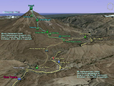
Tehran> Haraz Road> Polour Village> Camp1 Plour Hut> Base Camp
or
Mazandaran Province> Haraz Road> Reyneh Town> Camp1 Reyneh> Base Camp

Note
Most climbers who ascend to the summit from West, North East, or North Face prefer to descent from south face because of its easy descend footpaths !!

South Route Map Damavand
Mount Damavand South Route Map

West Route
This route has a very long access by car to the starting point and it is the second popular side of the mountain, but the distance from starting point to the Simorgh Camp is quite short.

Difficulty and climbing grade
It is a basic mountaineering, moderate walk-up, basic snow and cold, difficult descend.
(Farsi name for this camp is Panagah Simorgh).

Campsite
There is a new double stage shelter/refuge called Simorgh at about 4200m in this area.

How to go there
Tehran > Haraz Road> Polour Village> Camp1 Plour Hut> Simorgh Shelter

Note
Simorgh means Roc, the name comes from Iranian tales and refers to a gigantic legendary bird, said to carry off animals as big as elephants for his food.

East Route
This route also called the North-East Ridge, is the longest route to the summit and the third popular side of the mountain.

Difficulty and climbing grade
Route type is mountaineering with difficulty, hard ascend cold and windy, long descend.

Campsite
There is a shelter/refuge called Takht e Fereydoun Camp at about 43oom.
Persian name for this camp is : Panagah Takht e Fereydoun.

How to go there
Tehran > Haraz Road> Nandal Village> Takht e Fereydoun Shelter .

North Route
The north face is the most difficult side of the mountain.

Difficulty and climbing grade
Scramble mountaineering, steep, hard ascend, depending on season, cold and windy, snow & ice , difficult descend,

Campsites
There are two shelter/refuge on this route
Camp1 called 4000
Camp2 called 5000

GPS Landmark Table for Mt Damavand south route
Mt Damavand south route GPS Landmark Table

More in MDG
Mt damavand camps, iran mountain camps, mount federation iran campsites, resorts, shelter, panagah, refuge, lodge, hotel, hostel, suite, mountain resort, north east camp panagah tahkt feridon shelter, tahkt e fereydon refuge, west camp panagah simorgh shelter, simorq refuge, first camp, second camp, mid camp, last camp, camp1 polour, camp1 reineh hut, camp2 base shelter, base camp refuge, goosfand sara, saheb al zaman mosque, camp3 bargah sevom refuge/shelter, camp3 bargah new hut.

Technical info, gps landmark, gps track, gps waypoint, gps guide, gps iran, gps landmark iran mountain, route and trail map, foot stamp, route news 2010 iran, route map, trail map, photo damavand, foto, picture, pic, video, news, google earth route, south, east, west, north face, google earth satellite image iran, virtual tour google earth, info iran, maps and signs, shelters and huts route map, trekking and expedition route map, hiking & trekking map, trail map, how to go, how to reach, how to climb, climbing route, tehran to damavand, distance tehran to, facts and figures.

Routes MDG27JAN10A
Copyright © Mount Damavand Guide . All rights reserved.

Best Mount Damavand Climbing Experience with Local Guides

  Best Trekking & Ski Youring Guides in Mount Damavand’s Adventure The Role of Certified Guides in Mount Damavand’s Unique Adventure. Th...