Damavand-Polour
How to go to Camp1 Polour
9 February 2011, by Sherppa
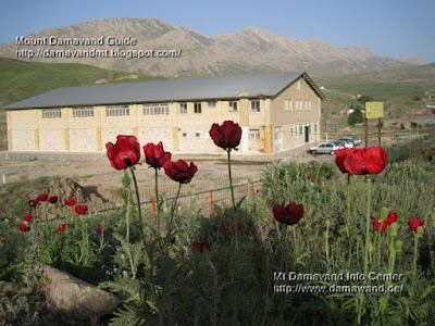
On the first day of your trip to Iran you may travel directly from IKA Airport or your hotel in Tehran to Polour Camp in Polour Village. This mountain resort is a shortcut and the best starting point for the south face and the west route of Damavand Mountain.
Detailed info for Camp1 Polour Hut.

Polour Village Junction to Camp1 Polour Road Map
How to go to Polour
Tehran > Haraz Road > Polour Village Junction> Camp1 Polor Hut
There is a good sign on the Haraz Road at the Polour Village Junction, statue of a mountaineer showes the correct location and your direction!
By Taxi
You may get a taxi to take you to Polour Village either from airport or any hotel in Tehran.Please note some taxi drivers do not know about the location of this mountain campsite.
By Bus
A cheap way is to go by bus, but there is no direct bus from airport or Tehran to this village. There is a major bus terminal in eastern Tehran called Terminal Shargh in Tehranpars area, at this terminal most buses go
to the north of Iran through Haraz Road, you should leave the bus at Polour Village Junction and then get a local taxi to Camp1 Polour.
Our Services
You may use our Services.
Location
Distance from Tehran 80 Km, about 2 hours by car
Distance to Camp2 Base, 1 hour by car ( 11.3 Km asphalt road + 6.4 Km gravel road )
See also Maps, GPS Landmark.

Tehran To Damavand Polour Village Road Map

Damavand Camp1 Polour
More in MDG
Iranian mount climbing federation camps, climbing guide iran, bed and breakfast accomodations, transfer for ika int airport tehran, mountain federation iran, refuge, resort, shelter, hostel, bargah sevom new hut, gps landmark, trail map, airport tehran, ikai airport to damavand, transfer ika international airport, travel and tour organizer, iran ski federation resorts, distance from tehran to damavand, google earth map, weather mount damavand iran دماوند ایران, alborz mountain range map, iran mountain trail, tehran mountains map, elevation of alborz mountain in iran.
Image of iran skiing in winter, photo, picture, snapshot, image produced by photographic, satellite pictures damavand mountains ski federation, iranian persian hiking groups, nature society, iranian mountaineering groups, does mount damavand iran get alot of avalanches, mt damavand basecamp, damavand kooh, best time for climbing, iran mountaineering guide, mountain climbing mistakes, iran climbing federation, haraz road weather forecast, carry heavy thing during climb, persian camp3, meteorology iran mountain climing, iran trecking itinerary, gps tracker in iran, tehran hiking, how long does it take to climb the zagros mountains.
Camp1 Polour Hut MDG09FEB11
Copyright © Mount Damavand Guide . All rights reserved.
Labels: Damavand Camp
<< Home