01 March 2011

Damavand-GPS


GPS Tracks
1 March 2011, by Sherppa

GPS Tracks for south route Mt Damavand Iran
GPS track is a useful data file which is recorded by a GPS receiver or a GPS tracker by using the Global Positioning System satellites, it helps and guides you to find the exact position of a path/track. It includs data such as time, speed, coordinate, (latitude, longitude) and altitude, it could be in different formats such as GPX, CSV, KML, KMZ ...You may convert it to your desired format by softwares like GPSBabel.

South Route GPS Track Damavand
Camp3 to Summit GPS Track, Damavand South Route
(Green line for ascend, red line for descend)

The data can be stored in a (handheld) gps device or a pc to show or simulate the exact location of a route/person to be displayed against a map backdrop when analysing the track.

Here you can download these useful GPS tracks files which assist your Damavand expedition, especially if you intend to explore the mountain without guide and by yourself only, these tracks help you the best footprints and footsteps

You can uploaded files to your gps device to determine your precise direction, or use it in google earth to see the tracks or to simolate the climbing, specially in case of bad weather and foggy condition, it helps to find the way and save your life.

The GPS Tracks in this topic is for climbing from south face through Camp1 Polour to the Damavand summit.
ie Camp1 Polour> Camp2 Base> Camp3 New Hut> Damavand Summit.

Remember, the clasic south route is the most recommended route to ascend Damavand and the best starting point is Cam1 Polour Hut.

Download GPS Track Files
For South Route in GPX Format
By Garmin Oregon 550 handheld gps navigator
(To save battery, some tracks are recorded when comming down!)

1- Track Camp1 to Camp2: Download
Track Gravel Road, by car in summer or walk in winter.

2- Track Camp2 to Camp3: Download

3- Ascend Trak Camp3 to Summit: Download
Climb from Old Shelter or New Hut to Mt Damavand peak.

4- Descend Track Summit to Camp3: Download
Return from top to Campsite3
Read more about this gps track in GPS Track 2

Visit also: GPS Landmark.

Damavand Mountain GPS Track
Camp2 Base to Camp3 New Hut GPS Track
South Route Damavand Iran


Damavand Mountain GPS Track
Camp1 Polour to Camp2 Base GPS Track
South Face Damavand Iran

More in MDIC
GPS tracking unit, track log data, the tracklist, gpx, kml format, g.p.s. track files, handheld g.p.s. receiver, descend from the summit, climbing slope, guideposts, g-p-s tracking systems, google maps and google earth, continuous tracking, navigation equipment, handheld g.p.s. receiver, live g.p.s tracking, satellite tracking system, g.p.s. tracking systems, mountaineering elborz and zagross mountains, ski mountaineering and snowboard tour, g.p.s. peak, map summit, google satellite, image, climbing tours, fake summit south route.

Expedition guided tour 2011, guide damavand iran, climbing and ski tour damavand iran 2011, hiking & trekking tours 2011, iran mountain federation, ski season and ski guided tour, route and trail map, desert and eco nature trekking, mount tourism info center, mount climbing federation iran, ski federation resorts, distance from tehran to damavand, alborz mountain range map, photo, picture, image, photographic, satellite pictures damavand basecamp, best climbing time, mount guide, weather forecast, winter temperature, demavand weather météo.

GPS Tracks MDG01MAR11
Copyright © Mount Damavand Guide . All rights reserved.

09 February 2011

Damavand-Polour


How to go to Camp1 Polour
9 February 2011, by Sherppa

On the first day of your trip to Iran you may travel directly from IKA Airport or your hotel in Tehran to Polour Camp in Polour Village. This mountain resort is a shortcut and the best starting point for the south face and the west route of Damavand Mountain.
Detailed info for Camp1 Polour Hut.

Map Tehran To Damavand
Polour Village Junction to Camp1 Polour Road Map

How to go to Polour
Tehran > Haraz Road > Polour Village Junction> Camp1 Polor Hut
There is a good sign on the Haraz Road at the Polour Village Junction, statue of a mountaineer showes the correct location and your direction!

By Taxi
You may get a taxi to take you to Polour Village either from airport or any hotel in Tehran.Please note some taxi drivers do not know about the location of this mountain campsite.

By Bus
A cheap way is to go by bus, but there is no direct bus from airport or Tehran to this village. There is a major bus terminal in eastern Tehran called Terminal Shargh in Tehranpars area, at this terminal most buses go
to the north of Iran through Haraz Road, you should leave the bus at Polour Village Junction and then get a local taxi to Camp1 Polour.

Our Services
You may use our Services.

Location
Distance from Tehran 80 Km, about 2 hours by car
Distance to Camp2 Base, 1 hour by car ( 11.3 Km asphalt road + 6.4 Km gravel road )

See also Maps, GPS Landmark.

Tehran To Damavand First Camp Map
Tehran To Damavand Polour Village Road Map


Damavand Camp One
Damavand Camp1 Polour

More in MDG
Iranian mount climbing federation camps, climbing guide iran, bed and breakfast accomodations, transfer for ika int airport tehran, mountain federation iran, refuge, resort, shelter, hostel, bargah sevom new hut, gps landmark, trail map, airport tehran, ikai airport to damavand, transfer ika international airport, travel and tour organizer, iran ski federation resorts, distance from tehran to damavand, google earth map, weather mount damavand iran دماوند ایران, alborz mountain range map, iran mountain trail, tehran mountains map, elevation of alborz mountain in iran.

Image of iran skiing in winter, photo, picture, snapshot, image produced by photographic, satellite pictures damavand mountains ski federation, iranian persian hiking groups, nature society, iranian mountaineering groups, does mount damavand iran get alot of avalanches, mt damavand basecamp, damavand kooh, best time for climbing, iran mountaineering guide, mountain climbing mistakes, iran climbing federation, haraz road weather forecast, carry heavy thing during climb, persian camp3, meteorology iran mountain climing, iran trecking itinerary, gps tracker in iran, tehran hiking, how long does it take to climb the zagros mountains.

Camp1 Polour Hut MDG09FEB11
Copyright © Mount Damavand Guide . All rights reserved.

08 February 2011

Damavand-Base


How to go to Camp2 Base
8 February 2011, by Sherppa

From camp1 Polour or Reyneh you can ask for a car to take you to Base Camp (Gusfandsara), remember most part of the road is gravel and it may not completely be useable in spring and winter and cars may not be able to go all the way, you may consider this gravel road "as far as car can go". The car for this part could be any strong 4WD car such as landrovers, Jeeps and mini trucks.

Note:
- Try to use landrover, Jeep and 4WD patrol cars,
- If you are more that two person, do not use mini trucks.

Detailed info For Camp2 Base Camp.

Damavand Base Camp Road Map

How to go to Base Camp 3050m
First Camp, Polour or Reyneh> Camp2 Base.
If you are going to start and leave the camp1 early morning, it is suggested to book a car in advance the day before your kick off, it usually takes about one hour to the area.

Location
Distance from Camp1 Polour one hour by car (mostly gravel road.
Ascent to Camp3 Bargah-e Sevom 4 t0 6 hours by slow walk
Descent from Camp3 Bargah-e Sevom 2 to 3 hours.
See also Damavand GPS waypoints.

See also Maps, GPS Landmark.

Damavand Base Camp
Damavand Base Camp

More in MDG
Iran mt climbing federation camps, mount climbing, transport ikai int airport, mount federation resort, bargah sevom refuge, shelter, bargah-e sevom camp, base shelter, gps trail map, ikai airport transfer, ikai int airport, iran tour organizer, ski federation resorts, google earth map, weather forecast, alborz mountains, ski in winter, photo, picture, satellite pictures, ski federation, persian hiking groups, basecamp, best climbing time, mountaineering guide, mount climbing, climbing federation, road weather forecast, camp3, meteo mountain climing, trecking itinerary, gps tracker in iran, tehran hiking, how long does it take to climb the zagros mountains, mount federation camps resorts, saheb al zaman mosque, simorgh shelter, panagah takht feridon refuge, mountain guide, ecosystem guide.

Base Camp MDG08FEB11
Copyright © Mount Damavand Guide . All rights reserved.
07 February 2011

Damavand-Rayneh


How to go to Reyneh
7 February 2011, by Sherppa

Reineh Resort is an old starting point, at the present time if you intend to go to Damavand from Tehran, you may use  Polour Hut in Polour Village which is a shortcut from Tehran and a better place for accomodation and acclimatization.

Detailed info for Camp1 Reyneh Hut.


Damavand Camp1 Reineh
Camp1 Reyneh Damavand, Iran

How to Go to Camp1 Reyneh
Tehran> Haraz Road> Poul Moon Junction> Reineh> Reyneh Hut

By Taxi
You may get a taxi to take you to Reyneh Town, either from airport or any hotel in Tehran.

By Bus
There is no direct bus to this town, you should go by taxi to the bus terminal called Terminal Shargh, in eastern part of Tehran and find a bus to go closed to the area at Haraz Road, Pol e Moon Junction, and get a local taxi to Reyneh Town, ie taxi + bus + taxi.

Services
You may use our Services .

Location
Distance from Tehran 100 Km, about 3 hours by car
Distance to Camp2 Base, 1 hour by car (mostly gravel road)

See also Maps, GPS Landmark.

Reineh Hut Damavand
Reyneh Hut Mt Damavand


Map Tehran To Damavand
Tehran To Mt Damavand Map

More in MDG
Iranian mount climbing federation camps, climbing guide iran, bed and breakfast accomodations, transfer for ika int airport tehran, mountain federation iran, refuge, resort, shelter, hostel, bargah sevom new hut, gps landmark, trail map, airport tehran, ikai airport to damavand, transfer ika international airport, tour organizer, iran ski federation resorts, distance from tehran to damavand, google earth map, weather damavand iran دماوند ایران, alborz mountain range map, iran mountain trail, tehran mountains map.

Image of iran skiing in winter, photo, picture, snapshot, image produced by photographic, satellite pictures damavand mountains ski federation, iranian persian hiking groups, nature society, iranian mountaineering groups, does mount damavand iran get alot of avalanches, mt damavand basecamp, damavand kooh, best time for climbing, iran mountaineering guide, mountain climbing mistakes, iran climbing federation, haraz road weather forecast, carry heavy thing during climb, persian camp3, meteorology iran mountain climing, iran trecking itinerary, gps tracker in iran, tehran hiking, how long does it take to climb the zagros mountains, elevation of alborz mountain in iran.

Camp1 Reyneh MDG07FEB11
Copyright © Mount Damavand Guide . All rights reserved.

06 February 2011

Damavand-Transport


Transport and Transfer
6 February 2011, Posted by Sherppa

Depending on the number of the participant in your team you should choose some sort of transport for your journey, city tours, IKA/Mehrabad Airport, Tehran hotel and to starting point of Damavand, it could be a private car/taxi, van taxi, mini/middle bus or a bus. Also the transportation for camp1 to camp2, which could be a Land Rover, Jeep or any 4WD patrol cars. Usually mountaineers have big luggage, duffel bag and backpacks, so for those stuffs extra room should be considered too.

Note:
- In city use only yellow or green cabs.
- Ask you cab at Airport/Hotel info desk.
- Saturdays, Sundays and Mondays are best for starting days.
- It is not recommended to be on the road on Iranian weekends (Thursday and Friday).

IKA Airport Tehran
IKA Airport Tehran, Iran

Transport and Transfer Services
Visit also full Services
We organize reliable and safe transport and transfer to various destination, just let us know the exact number of your team, date and time before your trip.

Destination to/from:
- Tehran IKAI and MehrAbad Airport airports.
- Tehran hotel.
- Starting point of Mt Damavand or other Iranian mountain.
- Camp1, Polour, Reyneh, Lasem.
- Camp2, Base Camp, Gusfansara.
- Iran Ski Resort.
- Any persian tourism site.

Transport Plus Driver Guide
- Bus, mini bus, med bus, private car, taxi, van, van taxi for cities.
- Land Rover, Jeep and 4WD cars + driver guide for deserts and mountains.
- Private car for travel to Iran cities plus driver guide.

IKAI Airport Tehran
IKAI Airport Tehran, Iran

More in MDG
Iran mount climbing federation camps, permit iran mountain federation, permit required to climb damavand iran, climbing guide iran mountain, hotels bed and breakfast accomodations iran address, transport for ika international airport tehran, iran mountain federation campsites, refuge, resort, shelter, hostel, reyneh, base camp, bargah sevom camp, bargah sevom new hut, gps landmark, trail map, mehrabad airport tehran, ika airport to mt damavand.

Transport from ika international airport tehran to dizin resort, travel tour organizer, 4wd expedition, iran ski federation resorts, distance from tehran, climbing alborz mountain zone, mountaineering damavand, tehran to shemshak GPS track and climbing map, peak waypoint and landmark, google map, google earth, resort shemshak in alborz mountains, climbing weather damavand iran دماوند ایران.

Transport and Transfer MDG06FEB11
Copyright © Mount Damavand Guide . All rights reserved.

05 February 2011

Damavand-Volcano


Damavand Volcano Geology
5 Feb 2011 by Geology Gsapubs
Gravity-driven deformation of Damavand volcano, Iran, detected through InSAR time series

Abstract
The detection and monitoring of gravity-driven volcano deformation are vital for understanding volcanic hazards such as landslides, lateral blasts, and debris avalanches. Although deformation has been detected at several large active volcanoes (e.g., Mount Etna, Vesuvius, Kilauea), these systems also exhibit persistent magmatic activity, obscuring the gravity-driven signals of ground motion.
Visit main source: Geology Gsapubs

Volcano Damavand Iran
Damavand Volcano, Iran

In this study we present a first interferometric synthetic aperture radar (InSAR) deformation time series at the dormant Damavand volcano in northern Iran, over the period A.D. 2003–2008. The high-resolution data show a lateral extension of the volcano at the relative rate of as much as ∼6 mm/yr accompanied by subsidence at the rate of as much as ∼5 mm/yr at the volcano summit. We find that lateral motion of the east flank is more significant than that of the west flank. On the basis of past understanding and modeling of deforming volcanoes elsewhere, we interpret this new evidence to reveal long-term, slow, gravity-driven deformation, possibly in the form of gravitational spreading, at Damavand. This persistent deformation activity is well expressed, although no volcanic activity was ever reported in history. This finding shows that magmatic activity is not required for spreading and highlights the importance of identifying long-lived gravity-driven deformation for hazard assessment at dormant or inactive volcanoes.

1- Department of Physics of the Earth, Section 2.1, GFZ (GeoForschungsZentrum) Telegrafenberg, D–14473 Potsdam, Germany
2- Geodesy and Geodynamics Department, National Cartographic Center, PO Box 13185-1684, Meraj Avenue, Tehran, Iran
3- School of Geological Sciences, University College Dublin, Belfield, Dublin 4, Ireland

First published online February 3, 2011,
Received 23 September 2010.
Revision received 6 October 2010.
Accepted 8 October 2010.


Volcano Damavand Iran

More in MDG
volcano north of tehran, satellite pictures damavand volcan, google earth file, google map, gps landmark, waypoint, track, national geography, simulation of volcano eruption, does volcan demavand iran get alot of avalanches, escalada do monte damavend, the last time damavand volcan erupted, accidents in damovand volcano, iranian mountain mythology, meteorology iran mountain climing, weather forecast iran summit, alborz mountain range volcano formation, historic eruptions of the volcano, highest stratovolcano asia, dormant volcano, summit vent, magma, emission of sulphur gas and steam, recorded eruption, hot springs, thermal spring, spa, steam vents, summit crater, cooling magma body, extinct volcano, young lava flow, summit vents, historical eruptions, iran volcanos.

Damavand Volcano Geology MDG05FEB11
Copyright © Mount Damavand Guide . All rights reserved.

04 February 2011

Damavand-Warning


Warning
4 February 2011, Posted by Sherppa.
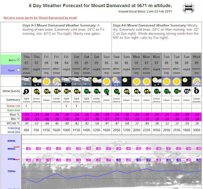
Winter Warning Freezing Temprature on Damavand

Warning freezing temprature for Winter Climbs, Ski Mountaineering and Snowboarding.
Damavand is very cold in winter and the temprature could drop to disaster quickly, the temp reaches far bellow -60° celsius with the wind speed more than 100km/h, very tough and freezing situation almost similar to the north/south pole.

Damavand Freezing Temprature
Freezing Temprature Mt Demavand, Iran.
-67° celsius (-88° Fahrenheit) 3 February 2011,
by Snow Forecast

If you intend to attempt any winter climbing, ski mountaineering or snowboarding expeditions to Mt Damavand Iran, you should be aware dangers and possibility of injuries, you must be well-equipped and well- experienced for difficult and harsh winter conditions, you need a good supporing team too.

You should also be aware that in case of emergency and injury, you better count on your own strenght and luck for surviving because rescue team and medical facilities are not available in the area, and if/when they arrive it could be too late. So extra care should be taken in winter and it is done by your own risk only.

Winter Temrature Damavand Iran
Winter Temprature on Mt Demavand, Iran.
-67° celsius (-88° Fahrenheit) 3 February 2011,
by Snow Forecast

More in MDG
Winter climb, skitouring, ski mountaineering and snowboard expedition elborz and zagros mountains iran, mount tourism info center, iran climbing federation, damawand ski touring, mountain climbing mistakes, alborz snow fall, best time for climbing damavand, shemshak and dizin ski resorts, best snowboarding iran 2011, winter mountaineering gear list, weather in winter, winter climb, ski mountaineering expeditions, weather condition damavand, disastrous weather in winter, strong winds.

Freezing temprature at the summit , harsh climate, rescue team and medical facilities for emergency, does mount damavand iran get alot of avalanches, damavand ski touring, best time for climbing damavand, is it safe to drink snowmelt, iran ski and climbing federation, best snowboarding in iran 2011, hotels bed and breakfast accomodations email address, mountaineering gear list, winter sports iran, transport for ika international airport tehran, ski mountaineering recommended gps.

Permission required to climb mount iran, climbing permit mount damavand, image of iran skiing in winter, photo, picture, snapshot, image produced by photographic, iran mountain climbing federation, iran ski federation iranian persian hiking groups, nature society at tehran, iran, iranian mountaineering groups, elborz mountain trek/skiing in winter 2011, grass ski tour guide, meteorology iran mountain climing, weather forecast iran summit, weather forecast damāvand iran دماوند ایران.

Winter Warning MDG04FEB11
Copyright © Mount Damavand Guide . All rights reserved.

Best Mount Damavand Climbing Experience with Local Guides

  Best Trekking & Ski Youring Guides in Mount Damavand’s Adventure The Role of Certified Guides in Mount Damavand’s Unique Adventure. Th...