08 March 2010

damavand-google-earth


Google Earth Maps 3
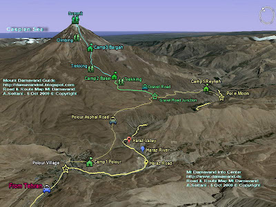
Before your actual attampt it is very helpful and fun to have a virtual travel to Mt Damavand by Google Earth, it gives you some good ideas and answers many of your questions. Install the Google Earth software on your PC or note book and download the placemark files, by just a single click on the files, you will travel to the area in few moments!!
You may download google earth files from: Google Earth Files .

In case you don`t have the software installed, you can download and see the Google Earth satellite images in the JPG format, total 14 useful pics. Google Earth Photos .

South Route Google Earth Photo Mt Damavand
Mt. Damavand South Route Google Earth Image


Mt Damavand by Google Earth

More in MDG
climbing and adventure tours alborz mountain range, mount camps information, altitude elevation height, attractions of iran, weather and climate haraz, image, picture, photo center, photo gallery foto, pictures encyclopedia of iran mountains, eruption of volcano, iran mountaineering federation, association organization society, poppy field tulip, south route elevation measurment, summer events calendar tour, skiing and climbing expedition, hiking & trekking and climbing tour, gps track waypoint landmark , route and trail map.

Google Earth MDG8MAR10B
Copyright © Mount Damavand Guide . All rights reserved.

07 March 2010

damavand-elevation


Elevation
Elevation of Mt Damavand Iran
Many sources indicate that the altitude of Mt Damavand is 5671m.
But the Wikipedia insists that the elevation of this volcano is only 5610m which I believe this is not correct. I had measured it before and I knew it was more that 5610m, but after reading this article, I made my new measurement on Friday 31 Aug 2007 at 11 AM.

Simultaneously, with two different brand of hand held GPS units, one Magellan GPS 315 and the other Garmin GPS Rino 120, by going to the top of all boulders and big rocks around the summit crater, I noticed all of them above 5610 M ! This is the result of my new measurement for the highest rock located on the south face which I beleive is summit of this mountain:

Summit Coordinate
Latitude 35-57-19 North
Longitude 52-06-37 East

Summit Altitude
By Magellan GPS 315 ---------- 5630 m - 18471 ft
By Garmin GPS Rino 120-------5645 m -18520 ft

If we assume the max tolerance of GPS units are +/-15M, in the worst case, the height is above 5610 M, ( ie 5630 - 15 = 5615 m ),
and for best and optimal the elevation is 5660 m -18569 ft or more,
( ie 5645 + 15 = 5660 m).

Although I believe the hand held GPS unit results may not be so accurate to refer to as a reliable reference, but I think it is more reliable that what is mentioned in Wikipedia! It worth to do some accurate measurements on the mountain with some modern and sophisticated equipments by some experts (and not newcomers)!

Mount Damavand Peak
Ardeshir Soltani on the highest point of Mt. Damavand 5671 meters
Photo by Ali Najafi

Read more, what NASA says about the elevation!

NASA1
In this topic NASA says the elevation is 5,670 meters (18,598 feet)
Mt. Damavand, Iran ...is an impressive stratovolcano that reaches 5,670 meters (18,598 feet) in elevation. Part of the Alborz Mountain Range that borders the Caspian Sea to the north, ...

NASA2
In this topic NASA indicates the elevation is 5681m (18,638 feet)
Iran: Elburz Mountains, Iran, and the more precipitous southern shore of the Caspian. Damavand volcano (5681 m) and ...

Mount Damavand Persia
Mount Damavand 5671 meters

More in MDG
Alborz mountains altitued and summits, articals mountains iran, mount adventure and climbing expedition, nature ecosystem mountains, nature and ecosystem gps track waypoint landmark, facts by gps, waypoint volcano, distance tehran to the mount, facts and figures, info route and trail map, google earth images south route, technical info, virtual trip and tour by google earth, informative guide book for height atitude and elevation, climbing and trekking tour mt damavand iran, distance tehran to south route, elburz mountains map, elevation by nasa, encyclopedia of iran mountains, equipment and gear, how long it takes to climb, how to climb, transport to and from the mountain how to get to volcano or to reach mount, technical info volcano, temperature and climate, wiki english, wikipedia english.

Elevation MDG7MAR10A
Copyright © Mount Damavand Guide . All rights reserved.

06 March 2010

damavand-photo1


Photo Gallery
Damavand Photo Gallery 1
Interesting images of mountain, hiking and trekking pictures, climbing and mountaineering pics, iran nature and ecosystem pics.

damavand early morning view from Polour Village, Photo by A. Soltani
Damavand morning view, by Ardeshir Soltani

Mt Damavand Hiking & Trekking above cloud Photo by Sherpa
Hiking & trekking Tour above clouds, Mt. Damawand Iran
by Sherppa

Damavand, final words just before the kick off! Photo by Ardeshir
Mt. Damawand, Final words from tour guide to his team just before the kick off !

A group of foreign climbers is led by MDG Sherppa
A group of foreign climbers is led by Sherppa of Mt Demavand

damavand poppy fields Photo by A. Soltani
Mt. Damawand, Natural red poppy fields start blooming beigining of May
by A. Soltani

More in MDG
Mountain and nature picture hikking & trekking expedition iran, image tour 2010, climb foto 2010, nature picture gallery, fptp persia, hiking and trekking tour 2010, pictures, pics, photos, fotos, images, videos, foto gallery, tour pics 2010, adventure tour foto, tour iran nature and ecosystem, trekking tour iran , news iran, weather iran, eco tour images.

Photo Gallery 1 MDG6MAR10B
Copyright © Mount Damavand Guide . All rights reserved.

damavand-map


Mt Damavand Maps 2
Helpful and interesting road, route and trail map, photos, pictures, images and aerial photographs of iran mount federation campsites, resorts, shelter/refuge, hut/lodge/hostel and mountain resorts, drawing and sketch that of footsteps, foot stamp and footprints.

Google Earth images as a reliable source, to gives you a clear indication about the routes, tracks, footpaths and the distances, together with GPS landmarks and watpoints for your trip, to shows you all the ways from Tehran to starting points and to the top, you will learn how to go to the summit of Iran and Middle East by your own.

Some original full size image maps are avalable free of cahrge, interested mountaineering groups and individual climbers may send their request with the title Mt Damavand Map in the email subject.

How to go to The Mountain
Tehran > Haraz Road > Polour Village > Polour Camp

Damavand Map
Map Damavand Iran


South Route Mount Damavand
South Route Campsite3 to summit


Map How to go to Damavand Mount
How to go to the mountain


Road Map Damavand Mt.
Road Map


Google Earth MapMount Damavand
Google Earth Map


Maps and Signs, By MDG

More in MDG
iran mountain camps, trekking and expedition map mount iran, gps landmark waypoint iran mountain, hiking & trekking map, alburz mountains map, how to go, how to reach, climbing route, distance tehran to mt damavand, hiking & trekking, how to climb, south route to summit, technical info and timing , trekking map and virtual trip by google earth, footpath, footstep and footprint, distance covered by a step, follow or tread in someone's footsteps, climb mountains, finding new places and enjoying the journey, moun guidebook, road and route map.

Travel and tour guide, topographies and elevations, finding places and enjoying the journey, routes for multi-day backpacking mount trips, hiking trial guide for beginner or casual hikers, moderate full day hikes, skill levels and, hiking trial guide book, trail and destinations distance tehran, facts and figures, how to climb, google earthsouth route, google earth virtual tour satellite image iran, virtual tour google earth, trekking and expedition route map, how to climb, tehran to damavand, distance tehran to, facts from camps to the peak.

Maps 1 MDG6MAR10A
Copyright © Mount Damavand Guide . All rights reserved.

05 March 2010

damavand-ski-tour


Ski Mountaineering
Mt Damavand 7 Days Hotel and Camping Ski Tour
Full package tailored-made skitour, the itinerary is custom design and flexible, let us know all logistic you need to finalize the tour.

The best months for Damavand ski mountaineering are January, February and March and depending to the weather and climate and the amount of snowfall, some times it is also possible to ski in April and early May too. If you intend to go to the summit, you must be very fit and experienced climber too.

We may offer you different custom designed ski tours for Mt Damavand, it depends to your level of fitness, you may choose any intinerary, one week or more. This is one of our suggested itinerary. You may make any alteration and modification to this package to best suit your programme.

Introduction
• Ski Mountaineering to summit of Iran and Middle East.
• Discover the Beauties of best Persian ski resorts.

Skiing Mount Damavand
Ski Mountaineering Mt Damavand Iran

Day 1: Arriving to Tehran
Greeting you at Tehran International Airport, IKA airport, transfer to 1st camp, we take you directly to Polour Hut, for acclimatization, over night at Polour Hut. You just rest there for acclimatization, no climbing or hard exercises and no pollution of Tehran weather.

Day 2: Starting Day - To Base Camp
Drive towards 2nd camp, as far as car go and strart trekking to Camp2 Base, over night Base Camp Shelter.

Day 3: To Third Camp
By slow trek, or on ski as far as the snow allows, to 3rd camp, over night at Camp3 New Hut.

Day 4: Acclimatization Day
Acclimatization day at Camp3, going to nearby heights, over night at Camp3 New Hut.

Day 5: Summit Day
We atempt climbing toward the summit, then ski down to camp3, over night at Camp3 New Hut.

Day 6: Return Day- Descend Back
Descend and ski down to Camp2 Base drive to Camp1, Return back to Tehran, over night at hotel .

Day 7: Reserved Day
Reserved day for bad weather or team being tired. We may have time to go to Termal Spring and then to your hotel in Tehran .
Transfer to Tehran International Airport, IKA airport, fly to your country, tour ends.

Included
• Permit fee for foreigners.
• Accomedation in Camp1 Hut and Camp3 New Hut.
Huts are the best place for accomedation in the area.
• All land transfers to and from Tehran.
Transfer from Airport or hotel (or to Camps) and back.
Transfer from Camp1 - Polour Camp to Camp2 Base as much as car can go, and back.
• All charges in Camp1 Hut & Camp3 New Hut
• High skilled ski guide.
• Hot meal in camps, food: breakfast, lunch, dinner, soft drink & cooking gear.
• Lunch box during the way.
• Hotel in Tehran.
• Sleeping bag and tent if necessary.
• Larijan Termal Spring.

Not Included
• Domestic Flights - we may buy your domestic ticket.
• This is the Land Only itinerary - Please make your own way to the tour starting point.

Mt Damavand South Route Vertical Drop, By Mount Damavand Guide
Mt Damavand Ski Vertical Drop

Ski Map Alborz Mountains and Damavand
Ski Area Map Alborz Mountains and Mt Damavand, Haraz and Chalus Roads

More in MDG
Mt. damavand iran, gps land mark and trail map, thermal spring spa and mineral water, skier news 2010, permit, cost and price,complete skitour package, hotel and camping, logistic and support, tailored-made tours, photo gallery, photo, picture, image, video, news 2010, resorts iran, best skiing routes, guided tours, mountain resort, downhill skiing, expedition, adventure tour, climbing expedition, experience tour guide.

Route and trail map, bad weather condition, strong winds, freezing temprature, harsh climate, rescue and medical facilities, services, mild skiable slopes fordescents, heavy winter snow falls in snow field, no gondola or tele cabin lift, snowboard, off-piste, iran ski federation, int ski federation fis, international competitions, skiing and snowboarding holiday tours to iran, best skiing route, ir downhill ski.

Ski Mountaineering MDG5MAR10B
Copyright © Mount Damavand Guide . All rights reserved.

03 March 2010

damavand-tips


Climbing Tips
Mt Damavand Climbing Tips Part1
Climbing to Mt Damavand summit is a geart memory, many climbers dream of climbing to this beautiful mountain, in this topic we share our experience and give you a collection of useful tips and tricks to ease your ascend to the top.

Mt Damavand ranks beside Mt Kilimanjaro in terms of difficulty and climbing grade. Technically speaking all you have to do is to trek about 8 kms distance in 10 hours time with a 26 deg mild slope and ascend 2630 meters from base camp to peak. See Facts And Figuers .

Climbing to this mountain is technically easy but physically a tough battle, prior to your ascend you better to read the essential info, the more you know, the more chance of success you have, we suggest you to read the following informative pages too: GPS Landmark,

- A good physical fitness is essential.
- The main challenge is Accommodation, start if you are ready.

- Best climb Timin is June, July and August.
- Recommended climbing Routes is the south face.

- An experienced and reliable mountain Guide is very helpful and will increases you chance of ascend.
- Use the day light only and never start at night, best starting time from camp 3 to the top is 5 to 6 am . See Common Mistakes

- Between Camp 2 Base to Camp 3 Bargah, do not carry heavy backpack or any heavy stuff . See How To Climb
- it is necessary to bring the proper Equipmen for a safe climb.

- Best Itinerary is 3 or 4 days.
- Best starting point is Camp 1 Polour.

- Camp 2 Base is not a suitable place for acclimatisation in summer, it is too crowded and too dirty, you better use Camp1 Polour or Camp 3 New Hut for acclimatization only. See Warning.

- Do not leave the camps and do not atempt climbig in bad Weather. You need a good weather for climbing in any season.
- If crowded, do not sleep in Camp 3 Bargah Shellter,you can book and use the new hut privte rooms.

Mt. Damavand Iran
Mt Damavand Iran
Photo by Anosh Soltani

More in MDG
Damavand guidebook, trip report, permit, photo gallery, routes and camps, services tehran, summit temperature, tips and tricks, route maps, mt kilimanjaro tanzania, mt fujiyama in Japan, adventure tours, alborz mountain range, articals mount damavand iran, bad weather, bargah sevom camp shelter, base camp shelter, best climbing route, damavand, camp, hut, lodge shelter, refuge, resort, camp1 polour hut, resort , polor village, camp1 reineh town, camp2 base shelter, camp3 bargah sevom shelter, camp3 new hut, resort.

Camp reineh, reyneh, climbing and trekking tour, climbing and eco tours, climbing sport federation, distance tehran to, alburz mountain map, first camp polour, polor, poolor, first camp reine, reyneh, rayneh, foto, photo, video, google earth, gps iran routes, gps landmark, guided tour iran tehran, haraz road to Camp 1 Polour, how to climb, how to get to, to reach mount, image, piture, photo, foto, pic, info, information, outdoor activity in Iran, photo hiking mountain and waterfalls, technical info volcano, transport to and from, travel guide, weather forecast, damavad, damawand, demavand, demawend.

Tips and Tricks MDG3MAR10D
Copyright © Mount Damavand Guide . All rights reserved.

damavand-ski


Ski Mountaineering
Ski Mountaineering, Mt Damavand Ski Resort
Damavand is a popular peak for mountaineering, due to its great height 5671m, easy skiable slopes and quick accessibility from capital city Tehran, it is gaining popularity rapidly for ski mountaineering off-piste and snowboard in recent decade.

There are mild downhill skiing slopes for descents up to 3000m, for sure it is one of the world's finest ski mountaineering resort, there are heavy winter snow falls in this field due to vicinity of Caspian Sea.

The south face it is not technical and it is the recommended route for ski, this side has mild slope for climbing up to the 5000m, after that height it gets a little steeper, skinning could be dangerous and difficult and on other faces. There is no gondola or telecabin lift in this ski resort, so you should ascend on feet or on ski and ski down.

Depending to the weather, the amount of snow differs each year, the ski season may starts from November or December and last untill mid May, tours generally go in March & April, it is highly recommended to check the snow condition in advance and before you fix your programme and travel to the area.

Damavand Winter view
Mount Damavand Winter view
Photo by A. Soltani

Targeted Activities
Climbing, hiking trekking, mountaineering, summer and winter climbing, skiing, snowboarding, off-piste skiing, ski mountaineering, down hill skiing, boarding.

Resort Statistics
Camp 1 Polour Hut
Camp 1 Reyneh

Camp 3 Bargah
Camp 3 New Hut

Quick Facts
Vertical Drop
You may freeride your way down from one of these places to the starting point Gravel Road Junction No5 in GPS Landmark:
3200 m from Summit
1700 m from Camp3 New Hut
600 m from Camp2 Base

Altitude: 5671m
Max Vertical Drop: 3200 m
Highest Resort Altitude: 4250 m
Lowest Resort Altitude: 2270 m

Snow Depths: 2 to 5m
Skiing at night: No
Distance from Tehran: 80km

Season Availability
Skiing season varies from November to April
Open to Public: 7 days a week, all year round.

Disadvantage
No lift facilities, telecabin, gonola ot cable cars

Weather
6 Day Weather Forecast for Mt Damavand

Location
Located on Haraz Road 80km North East of Tehran , in Mazandaran Province.

Nearest Airport
IKA International Airport or Mehrabad Airport Tehran, Iran.

How to go, Transportation
Fly to Tehran IKA International Airport and then travel by road to Polour Village or Reyneh Town. The journey time is about 1.5 to twoo hours drive from Tehran. After a heavy snowfall, snow chains may be necessary for some part of the journey. There is no railway station in the area, the closest railway station is at Tehran.
Note - Haraz Road is crowded with traffic jams in holidays and weekends.

Major ski resorts near the area
Ali Ski Resort
Darbandsar Ski Resort
Dizin Ski Resort
Lasem off piste ski area
Shemshak Ski Resort
Tochal Ski Resort

Other Ski Resort In Iran
Alvares, Ardabil
Ardakan, Fars
Chelgard, Shahr e Kord
Dena Yasuj
Kakan, Yasuj
Khor, Khoor
Khoshaku, Urmi
Kuhrang, Kohrang, Bakhtiyari
Sabalan Ardabil
Sahand, Tabriz
Sepidan, Kohkiluyeh v Boyerahmad
Shahmirzad, Semnan
Shandiz, Khorasan
Shirkoh Yazd
Tarik darreh, Hamadan

Warning
Mt Damavand weather could change to disastrous quickly in winter, with freezing temp falling bellow -60°C at the top and winds speed above 100km/h, you should be well-experienced for such a tough winter climb or ski expeditions in harsh condition and be aware that rescue team and medical facilities are not available in case of any accident, avalanche, injury or emergency condition, you must rely only on your own experience and good luck for surviving, so it is very essential to take extra care for either climbing or skiing on Mt. Damavand in winter and it is done by your own risk only. Visit also Disclaimer

Mt. Damavand Winter view
Mt Damavand Ski Mountaineering Photo by A. Soltani


South Route Map Mt Damavand
Mt. Damavand South Route Map

More in MDG
Warning bad weather condition, disastrous in winter, strong winds up to 100km/h, freezing temprature reaching -60°C at the summit, harsh climate, rescue and medical facilities, injury and emergency, surviving, services for ski, mild skiable slopes for descents, caspian sea, heavy winter snow falls in snow field, no gondola or tele cabin lift, skiing, ski mountaineering and snowboard.

On-piste, off-piste, iran ski federation, int ski federation fis, international competitions, skiing and snowboarding holiday tours to Iran for january, february and march 2010, permit for foreigner, land transfers to and from tehran, camp resort and hotel reservation, experienced ski guide, hiking & trekking tour iran 2010, route map, photo and picture, best skiing route, downhill ski iran.

Ski Mountaineering 1 MDG3MAR10C
Copyright © Mount Damavand Guide . All rights reserved.

Best Mount Damavand Climbing Experience with Local Guides

  Best Trekking & Ski Youring Guides in Mount Damavand’s Adventure The Role of Certified Guides in Mount Damavand’s Unique Adventure. Th...